|


|
|||
|
|
|
|
| The Phoenix Islands Protected Area (PIPA) is the largest marine protected area in the Pacific Ocean. As part of the permitting process which enables us to work on Nikumaroro, we are required to submit a report to PIPA at the end of each expedition, describing what we did, what we saw, and including video and still images of the island and its environment. The report was delivered in person by Ric Gillespie on June 23, 2011, in Tarawa, and is published below. There are also numerous appendices which are published in the Analysis section.
|
|||||||||
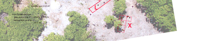
Appendix A Excavations at the Seven Site: 2010 Thomas F. King, Ph.D. Research Design The 2001 and 2007 field seasons at the Seven Site had shown us several things, notably:
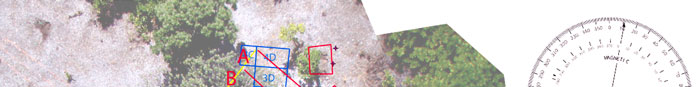
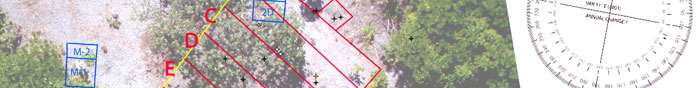
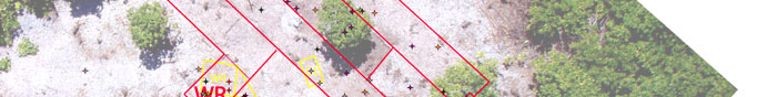
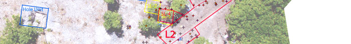
These observations led us to decide on a strategy of large-area exposure – stripping the top 10 cm. off a large portion of the site and recording/collecting everything found. Like all archaeology, this strategy involved destroying much of what we were trying to study, but we hoped it would reveal the overall organization of the site and enable us to find and interpret both metallic and non-metallic material. One important caveat needs to be noted at the outset. When we speak of exposing a “large portion of the site,” this implies that we know how extensive the “site” actually is, and we actually do not. The areas in which we worked in 2001 and 2007, both embraced within the larger area we worked in 2010, contain distributions of artifacts and features that do not seem to extend beyond the boundaries of the area we have each time temporarily cleared of Scaevola; transects cut into the bush beyond these boundaries and inspected visually and with metal detectors have not revealed additional features or obvious artifact clusters. However, we cannot say for certain that we have established the full extent of the site. The excavation strategy involved laying out a series of parallel 2-meter-wide “lanes” running along the axis of the surge ridge and excavating these to 10 cm. depth by trowel. This operation, involving the whole team working on a sort of skirmish line, was referred to colloquially as &lduo;Rolling Thunder.” A total station established over permanent datum 3 (as established in 2001) would be used to shoot in locations of all apparently significant artifacts and features encountered. Material like shell, animal bones, and the ubiquitous fragments of corrugated and other iron would be collected by 2-meter lane sections, and a running sketch-plan would be maintained of each lane. A video record would be kept of the whole operation, employing a photo tower constructed near the southeast edge of the site, and once cleared, the site would be imaged repeatedly using kite aerial photography (KAP). Artifacts or bones that might contain DNA would be collected under sterile conditions. Once Taylor Keen and the ground-penetrating radar (GPR) arrived on the second ship, GPR would be used to scan the site beyond the excavated area; the daylight ultraviolet (UV) scanner employed in 2007 would also be used. Team Assignments Tom King was in overall charge of Seven Site operations, assisted by Gary Quigg and Meg Lickliter-Mundon. Tom Roberts and Meg Lickliter-Mundon handled the total station, and Meg also was responsible for the recovery, labeling and bagging of specific artifacts, including those recovered in accordance with the DNA protocol. Bill Carter and Karl Kern comprised what we called the “Dynamic Duo” team, using chain saws and loppers to cut a broad avenue (the “Carter-Kern Highway” southeast of the apparent site boundary for about 50 meters along the ridge crest and then eastward to the beach; this permitted intensive inspection of a sample of the ridge beyond our major search area, and facilitated the removal of cut Scaevola. Taylor Keen was in charge of GPR. Jon Overholt and Karl Kern took charge of tree-ring boring (discussed below). Andrew McKenna handled the UV scanner. In addition to his responsibilities as expedition leader, Ric Gillespie led a systematic search of coconut crab lairs northwest of the main excavation area, in the event these might contain bones carried to them by their occupants, and conducted period metal detector sweeps of areas under investigation. Mark Smith conducted video documentation. Fieldwork Work began as usual with a brush-clearing operation. Scaevola was cut using pneumatic loppers and chain saws, and carried to a slash pile on the lagoon shore. Once the Dynamic Duo had opened the Carter-Kern Highway, Scaevola was also carried to the ocean beach. We opened up an area embracing all the areas previously inspected in 2001 and 2007, and extending somewhat farther along the ridge to the southeast. Trees that were not Scaevola were left in place. Once the basic working area was cleared, we laid out a 15-meter base line (a nylon rope staked at both ends) perpendicular to the axis of the ridge, just northwest of the “Big Ren” and the “D” units excavated in 2001. The baseline rope had nylon strings attached every 2 meters. Stretched out perpendicular to the base line and staked, these formed seven 2-meter-wide lanes, designated Lanes A through G. Two team members then took each lane and began systematically troweling toward the southeast, stripping the surface down to 10 cm. depth. Each “lane team” was responsible for keeping a running record of its observations, using standard “lane forms,” for collecting ecofacts and such common artifacts as ferrous fragments by 2-meter segment and/or by observable feature, and for calling on Meg and Tom to record specific locations and recover artifacts. As work progressed, at Megan’s suggestion two more lanes, L and L-2, were laid out perpendicular to lanes A through G at the southeast edge of the site, and excavated in the same manner as the other lanes. A standard 2x2M unit was added to the block of "SL" units dug in 2007. Another group of units was excavated beyond the L and L-2 lanes to explore a metal detector hit at the head of the Carter-Kern Highway; these were designated the X-units. GPR, UV, and metal detector scans were conducted in 15x15 meter blocks NW and SE of the main study area; shovel test pits and one 1x2M unit were dug to explore apparent GPR anomalies. Figure 1 is a map of all excavations and related scans. Ground-Penetrating Radar and Ultraviolet Scanning A Ground Penetrating Radar (GPR) unit loaned by TreeRadar of Silver Spring, Maryland and operated by Taylor Keen of the University of Maryland did not produce useful results. It was found that small pockets of air in the matrix of coral rubble create false targets for GPR. Ultraviolet Scanning was employed over large sections of the study area but no bones were discovered using this technology. Tree Borings Gallagher, it will be recalled, described the bones found in 1940 as lying under a ren (Tournefortia) tree. We were curious to determine whether the “Big Ren” at the Seven Site might be old enough to be Gallagher’s ren. It is generally understood that dendrochronology works poorly if at all in the Pacific, because trees do not lay on annular rings that reflect seasonal changes. However, we thought that trees on Nikumaroro might reflect periods of drought in their ring structure, and that these might be dated using historical records. Accordingly, we undertook a systematic program of tree-boring, using equipment generously loaned by the University of Maryland. In all, five rens were bored – the Big Ren plus four smaller trees found by the Dynamic Duo along and rather beyond the Carter-Kern Highway. In addition, two sections were cut from a large dead north of the Big Ren. The resulting cores and sections were to be processed by Taylor Keen of the University of Maryland.
|
|||||||||
|
|
||||||||||||