- Welcome to TIGHAR.
The International Group for Historic Aircraft Recovery
Recent posts
#81
General discussion / Re: Chater Report Better Scan
Last post by Randy Conrad - November 02, 2025, 12:47:38 PMhttps://timeandnavigation.si.edu/research/amelia-earhart-and-the-profession-of-air-navigation
I posted this article from the Smithsonian after searching Google for any inkling that Fred Noonan might have had some morse code training even as a navigator. This whole round the world trip was a death trap from the start. One of the things I'm mystified about is Paul Manning work on the radio prior to the flight. We know that Amelia let him go because of dissatisfaction in his work. So now I'm wandering how much training did he have in radio knowledge. I'm almost led to believe that Manning sabotaged the Electra to teach Amelia a lesson ..that she doesn't know everything about everything. I guess I'm stooped as to why anyone would fly alone with someone who didn't have the slightest inkling about morse code. Basically, this flight was set for failure from the start. Thank you Monty for sharing this article. One thing I'm curious about is the code name BLACK ITASCA in this document. Can someone please shed some light on this subject. Thanks
I posted this article from the Smithsonian after searching Google for any inkling that Fred Noonan might have had some morse code training even as a navigator. This whole round the world trip was a death trap from the start. One of the things I'm mystified about is Paul Manning work on the radio prior to the flight. We know that Amelia let him go because of dissatisfaction in his work. So now I'm wandering how much training did he have in radio knowledge. I'm almost led to believe that Manning sabotaged the Electra to teach Amelia a lesson ..that she doesn't know everything about everything. I guess I'm stooped as to why anyone would fly alone with someone who didn't have the slightest inkling about morse code. Basically, this flight was set for failure from the start. Thank you Monty for sharing this article. One thing I'm curious about is the code name BLACK ITASCA in this document. Can someone please shed some light on this subject. Thanks
#82
General discussion / Re: Chater Report Better Scan
Last post by Martin X. Moleski, SJ - November 01, 2025, 03:22:47 AMThis is a transcription:
https://tighar.org/Projects/Earhart/Archives/Documents/Chater_Report.html
The page does not answer your question about where the original is at present.
Still in Vancouver, perhaps?
Book excerpt: Book excerpt: Placer Development and Amelia Earhart's final flight:
https://tighar.org/Projects/Earhart/Archives/Documents/Chater_Report.html
The page does not answer your question about where the original is at present.
Still in Vancouver, perhaps?
Book excerpt: Book excerpt: Placer Development and Amelia Earhart's final flight:
QuoteTIGHAR's conclusions were aided unexpectedly by the discovery of a file marked "Bulolo Gold Dredging, Ltd./Amelia Earhart" in Placer Dome's basement storage in Vancouver about 1991. The file contained a report for the U.S. Bureau of Air Commerce written by Eric Chater, General Manager of Guinea Airways at Lae, three weeks after Earhart's disappearance.
It was written after the Bureau asked Frank Griffin, a Placer Development director in San Francisco, for any "information of interest relative to Miss Earhart's visit and flight," and Griffin cabled Chater for help.
Of particular interest to TIGHAR were the confirmation of the fuel load carried, and the fact that Earhart made an unsuccessful attempt to test her radio direction finder prior to that flight.
"We greatly appreciate Placer Dome's generosity in making it [Chater's report] available," TIGHAR said.
#83
General discussion / Chater Report Better Scan
Last post by Travis Nutsch - October 31, 2025, 03:32:22 PMIs there a better scanned original version of the Chater report anywhere? Where is the physical copy of the archived version...?
Please and Thank you!
Please and Thank you!
#84
General discussion / Re: Google Earth Pro Satellite...
Last post by Denise Kelsey - October 30, 2025, 05:21:26 PMBingo. I think Jon nailed it (although the islet seems to have disappeared).
#85
General discussion / Re: Google Earth Pro Satellite...
Last post by Jon Romig - October 30, 2025, 07:23:59 AMIs it this coral rock? I still think someone should look for artifacts around the base of this rock. Long shot for sure, but to date unexplored.
Jon
Jon
#86
General discussion / Re: Google Earth Pro Satellite...
Last post by Randy Conrad - October 29, 2025, 11:14:30 PMA few days ago I sent Ric an email in regards to the photos that Google Earth had of the image. Ric did mention that it was a coral block and mentioned some members of the team had seen it several years back. Granted I believe Ric whole heartedly..but trying to figure out why this coral block is flat on the edges with what appears to be holes on both sides at the top. As shown the picture changed dramatically and turned Google Earth around and caught it from an angle. So I dont know what to believe but another member thought it too was 10 ft in length. So if any members of past expeditions have photos of this or if someone has Google Earth live..I would love to see this first hand. Anyway, sure appreciate your thoughts an input on this image!!
#87
General discussion / Re: Google Earth Pro Satellite...
Last post by Jeff Lange - October 28, 2025, 04:46:18 PMI personally am already sick of the hype the MSM is making of this "expedition". They are basing it all on 10 year old photographic evidence, and we know there hasn't been anything there when we have been there. How come our little outfit never gets the MSM spamming coverage when we do something?
As far as your images- interesting to say the least.
As far as your images- interesting to say the least.
#88
General discussion / Re: Google Earth Pro Satellite...
Last post by Martin X. Moleski, SJ - October 28, 2025, 08:08:34 AMMarch 18, 2022 Google Earth imagery
#89
General discussion / Re: Google Earth Pro Satellite...
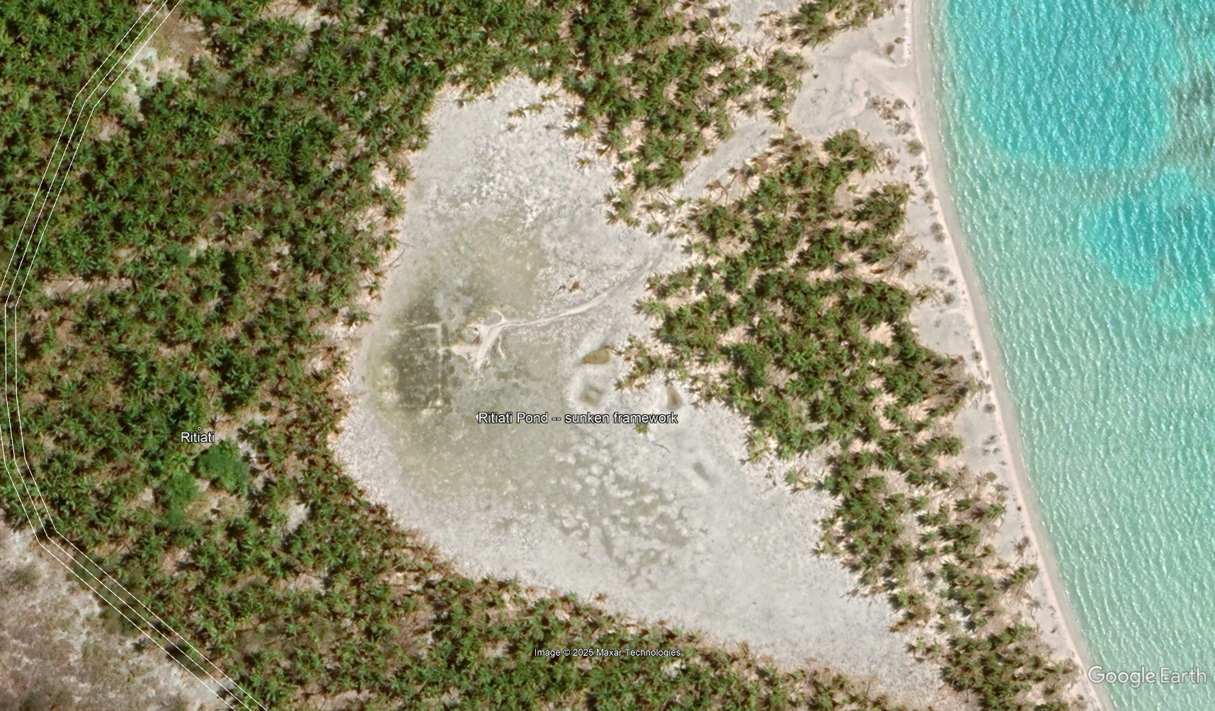
Last post by Martin X. Moleski, SJ - October 28, 2025, 07:38:26 AMOne of my most interesting Google Earth explorations was to look at every image Google has collected of Ritiati Pond.
It was evidently filled with structures during the colonial era.
In times of drought, the remnants of the structures emerge more clearly.

It was evidently filled with structures during the colonial era.
In times of drought, the remnants of the structures emerge more clearly.
#90
General discussion / Re: Google Earth Pro Satellite...
Last post by BillN - October 27, 2025, 02:44:28 PMThanks for posting Randy. I saw that recently and wondered if anyone else noticed it. Using Goggle's measuring tool its about 10' by 5' by my best estimate. It also shows up around the same spot for several GE historical images. Wonder if the November expedition folks would want to have a gander?