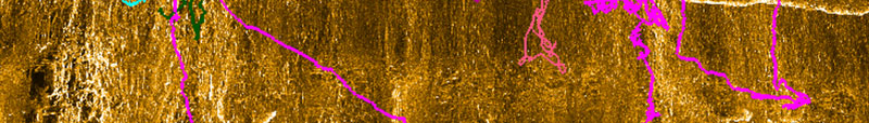
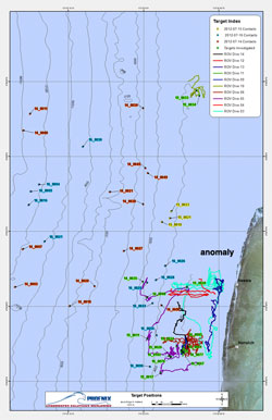
This is the map of ROV Dive 3 published in TIGHAR Tracks in which Richie Conroy spotted the anomaly. TIGHAR Amelia Earhart Search Forum, March 7, 2013: “Ric, the image I have attached shows an anomaly below second cliff which arrow points to. Do you have a sonar image with better detail?”
Looking at the map of all the ROV tracks it was apparent that we had never been to the place where the anomaly appears.
The anomaly is in the catchment area at the base of the second cliff.
How Good Is It?
The interpretation of sonar imagery is an art, not a science. To get a feel for whether this sonar target is as promising as it looks to us, we asked for the opinions of experts who work with sonar images for a living and, as is usually the case, interpretations differ. Opinions range from “almost certainly a man-made object” to “probably geology” but everyone who has reviewed the data agrees that the target is worthy of further investigation.
 The most colorful feedback was from Wolfgang Burnside, president of Submersible Systems, Inc. and the inventor and pilot of the TRV-M Remote Operated Vehicle (ROV) we used during last summer’s expedition. Wolfgang spent over 32 hours searching the reef slope at Nikumaroro and knows its terrain better than anyone. His reaction to the sonar image is best read aloud in a thick Fifeshire Scots brogue: The most colorful feedback was from Wolfgang Burnside, president of Submersible Systems, Inc. and the inventor and pilot of the TRV-M Remote Operated Vehicle (ROV) we used during last summer’s expedition. Wolfgang spent over 32 hours searching the reef slope at Nikumaroro and knows its terrain better than anyone. His reaction to the sonar image is best read aloud in a thick Fifeshire Scots brogue:
“Bloody Hell…….. well, we did look across the first “Catchment” ledge, but, for some reason we cut our excursion / survey short when we tried to follow the next “Catchment” ledge……if only we had continued just that little bit further!!
This Target looks VERY promising, definitely NOT a Rock, it’s in the correct location on the Reef and also shows what I interpret as ‘drag’ markings on the Reef above and to the North behind the target as it obviously hasn’t quite settled into its final resting place yet, this movement is probably due to the occasional Storms or exceptional Tides that’ll move the target a few inches every time one blows through.
Question is, how long will the Target remain in that location before it gets the final nudge that will send it over the edge of the “Catchment” area and disappear down the 70 degree incline into the depths?
Thank you so much for sharing Ric, I have also been looking through the raw Video footage, from time to time, but, sadly, have not really come up with anything as close to promising as you have……..smarty pants!”
So did the Niku VII expedition actually succeed in locating the wreckage of the world’s most famous missing airplane? Or is this sonar target just a coral rock or ridge? Of course we’re not going to know until we can get back out there, but until then the anomaly is worth close study.
One of These Things is Not Like the Others…
The first thing we can say about the object is that there is nothing else like it in the entire mosaic of side-scan sonar data. Whatever it is, it is truly an anomaly in the context of the reef slope at Nikumaroro and when you’re searching for man-made objects against a natural background, anomalies are good.
Size Counts
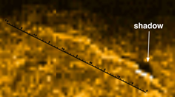
The next question is scale. How big is it? It can’t be wreckage from the airplane if it’s bigger than the airplane. By scaling it to known distances and the reported dimensions of identified targets, the most prominent part of the anomaly appears to be less than 10 meters (32 feet) long. The Electra fuselage was 11.76 meters (38 feet 7 inches) long. The height of the anomaly is harder to estimate. The only clue we have is the shadow – remember that it’s a sound shadow, not a light shadow – which suggests that the object is higher on the downhill end.
Breaking Up is Hard To Do
TIGHAR teams have visited and studied three Electra crash sites.
- c/n 1103 flew smack into Mt. Richmond in New Zealand in 1942 killing all five on board;
- c/n 1024 crashed near Kellogg, Idaho in 1936 with only mail on board. The pilot and copilot died on impact. (The crash site is the subject of this year’s TIGHAR Aviation Archaeology Field School.)
- c/n 1021 made a crash landing in trees in the Misty Fjords Wilderness Area east of Ketchikan, Alaska in 1943. All five passengers and the pilot survived the crash but one passenger succumbed of injuries two days later and the pilot died trying to hike out to bring help.
Each wreck has given us valuable information about what happens to a Lockheed Model 10 in different crash scenarios. Of the three, the Alaska wreck is the most analogous to the forces and damage to be expected in the case of an Electra going into the surf on a coral reef. In the Alaska crash the aircraft shed its engines, right wing, and tail surfaces as it came down through the trees. The center section, with its massive main beam, reinforced inner wing sections and thick belly skins, held together but the thinner cockpit and cabin skins were torn open. The empennage (tail section) separated just behind the wing.
|
|
 |
| The wreckage of c/n 1021 faces uphill behind the TIGHAR / U.S. Forest Service team that surveyed the site in 2003. |
One possibility is that we’re seeing the center section lying at an angle, much as we see in the Alaska crash, with the port-side wing stub causing the elongated shadow in the sonar image.
The Tale of the Tail
A unique feature of the anomaly is the sonar “tail” that extends uphill and northward behind the more prominent portion of the target that is casting a large shadow. Our initial impression was that the tail is, in aircraft crash investigation parlance, a “ground scar.” Such scarring is common when aircraft come to earth in ways other than we would normally prefer. However, after examining the nature of the underwater terrain in video (see Base of the 2nd Cliff) taken at about the same depth 50 meters away (the closest we have) it’s difficult to imagine a skidding fuselage plowing a furrow that would persist for 75 years.
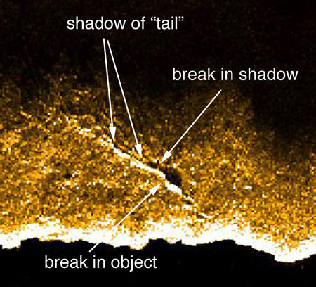 A higher-resolution copy of the image captured from the raw sonar data reveals details that suggest another explanation for the sonar tail. There appears to be a break in the prominent part of the anomaly, corroborated by a break in the shadow. Also, some of the tail is casting a low shadow so it must have some elevation. Something that always strikes us about Electra wrecks or repair shops where Electras are being restored or rebuilt is the incredible amount of “junk” that came out of the airplane. Rather than a ground scar, a more likely hypothesis is that the tail is a debris field of fuselage wreckage, internal components, cables, crushed fuel tanks, etc. strewn behind the eviscerated center section. A higher-resolution copy of the image captured from the raw sonar data reveals details that suggest another explanation for the sonar tail. There appears to be a break in the prominent part of the anomaly, corroborated by a break in the shadow. Also, some of the tail is casting a low shadow so it must have some elevation. Something that always strikes us about Electra wrecks or repair shops where Electras are being restored or rebuilt is the incredible amount of “junk” that came out of the airplane. Rather than a ground scar, a more likely hypothesis is that the tail is a debris field of fuselage wreckage, internal components, cables, crushed fuel tanks, etc. strewn behind the eviscerated center section.
Location, Location, Location
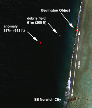
Finally, it’s worth noting that the anomaly lines up nicely with the Bevington Object and Jeff Glickman’s debris field. You can draw a straight line between any two points, but a line that connects three points, each point deeper than the next and consistent with the southerly flowing current, suggests that the three points are related.
Next Steps
The better a piece of evidence looks, the harder you have to try to disqualify it. So far, the harder we’ve looked at this anomaly, the better it looks. Maybe the anomaly is a coral feature that just happens to give a sonar return unlike any other coral feature on the entire reef slope. Maybe it’s a sunken fishing boat that isn’t mentioned in any of the historical literature. Maybe it’s the boat nobody knows about that that brought the castaway nobody missed who died at the Seven Site. Maybe it’s pure coincidence that it‘s the right size and shape to be the Electra wreckage – the Electra that so much other evidence suggests should be in that location.
We’re not going to know until we can get back out there and we’re not going to get back out there until we settle the debts from the last trip and raise the money for the next one. Meanwhile, we can’t help but wonder what else was missed in the sonar data. The next step, therefore, is a complete review of all the sonar data by independent experts. It will cost money – money that we don’t have right now – but we’re hopeful that contributors will step forward with donations large and small to make it possible. Please do what you can today. |


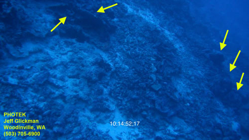 After reviewing all of the underwater HD video, the only site of interest identified by forensic imaging specialist Jeff Glickman is a small debris field of objects in relatively shallow water – 61 meters (200 feet). As reported in
  The debris field in the video is, however, in a catchment area at the base of a cliff and just downstream (the current flows southward in that area) of the spot where the Bevington Object appears in the 1937 photo. When Jeff was reviewing the video, so as not to bias his assessment, he purposely was not aware of where on the reef slope the video was taken. Only after he spotted the debris field did we calculate where it was.