| From the perspective of probabilities, here are my opinions. These are subjective and are based upon my knowledge and experience as opposed to being objective, calculated probabilities. |
 |
1. |
What is the probability that we have found man-made items in the dive imagery? |
| |
100%. There are key features in the patterns of shape and texture that can be used to differentiate man-made objects from natural objects, in this case, marine flora and fauna. These key features are present in several locations in the dive videos. |
| 2. |
What is the probability that we have found man-made items that do not originate from the S.S. Norwich City shipwreck? |
| |
100%.
The Norwich City man-made debris is differentiated both in location and by material and construction. The Norwich City debris is comprised of heavy, bulky materials, that are both close and below the wreck. There is additional man-made debris that is below and near the Bevington Object that is not bulky, but instead is smaller and lighter-weight in appearance. |
| 3. |
What is probability that the man-made items that we have found in the dive imagery are related to the Bevington object? |
| |
80%.
We have located a man-made debris field that is in the location that was expected and for which the shapes of the objects in the debris field are consistent with the object(s) seen in the Bevington image. |
| 4. What is the probability that Bevington object is a Lockheed Electra 10E landing gear? |
80% (previously 60%).
Ric has recently proposed an alternate segmentation of the Bevington image that I support. This reparsing is forensically consistent with the landing gear fork and increases my confidence that the Bevington object may be a Lockheed Electra landing gear.
|
|
| Although we have identified a number of objects in the high-definition footage that might be aircraft debris, Jeff is presently concentrating on the objects he spotted that may be components of the same object we see in the 1937 Bevington Photo. The reason is simple. It is far more efficient to ask whether an unknown object is just like a known object (in this case the landing gear of a Lockheed Electra) than to ask whether it is like any of an almost unlimited variety of possible objects. |
An important step in forensic imaging analysis is rendering the photo in a clearer way without introducing information that is not really there. The original screen capture of the features that might be components of the Bevington Object is a confusing jumble of different shades of blue because the water at that depth filters out the other colors in the spectrum. Removing the color and processing the image to sharpen edges improves the clarity without altering the information that is there. [TIGHAR photos. Click on either small image to open a large version of both in a new window.] |
|
 |
 |
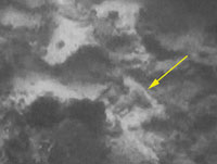 |
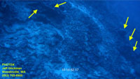
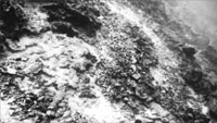
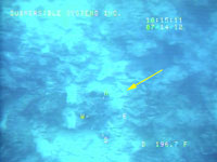
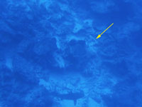
| An object encountered during Dive 3 on July 14 provides a good illustration of how imagery can be deceiving. In the screen capture at left from the standard definition video – the best quality we were able to see in real time – an angular object (yellow arrow) is so indistinct that we didn’t notice it at the time. In the High Definition video (center) that could only be examined later, the object looks convincingly man-made. (The shark does not.) In the black and white processed version (right) it is apparent that the object is not an object at all but sand visible behind marine growth. [TIGHAR photos. Click on any small image to open a large version of all in a new window.] |
|
Just as the documented landing of the ST-18 Croydon on a reef near Australia in 1936 (see Better Than Average Luck) mirrors Earhart’s supposed landing on the reef at Gardner Island a year later, the 1929 grounding and subsequent break-up of S.S. Norwich City on that same reef provides a model for what happens when man-made debris tumbles down the underwater slope. |
The Norwich City Debris Field
S.S. Norwich City went aground on the reef at Gardner Island on the night of November 29, 1929. The first half of the 397 foot, 5,600 ton freighter was driven up onto the reef surface with the stern half hanging out over the reef edge.
 |
 |
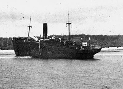
This 1935 photo is the earliest known picture of Norwich City aground on the reef at Gardner Island. Her back is broken but the vessel is still largely intact. TIGHAR Collection.
|
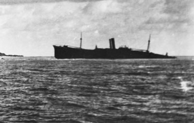
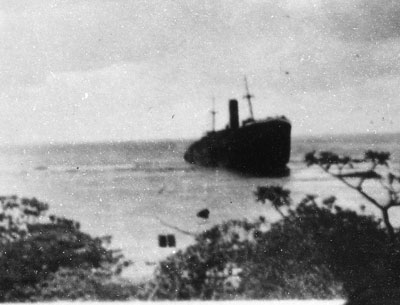
As shown in the now-famous Bevington Photo, by October of 1937 the stern half of the ship not supported by the reef was starting to sag. TIGHAR Collection.
|
 |
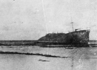 |
When a New Zealand survey party arrived in December 1938 to assess the island for possible airfield construction, the ship looked much as it did in the Bevington Photo. TIGHAR Collection.
|
Less than a month later, in January 1939, while the New Zealanders were still there, a storm caused the stern to break off and tumble down the reef slope. TIGHAR Collection.
|
 |
 |
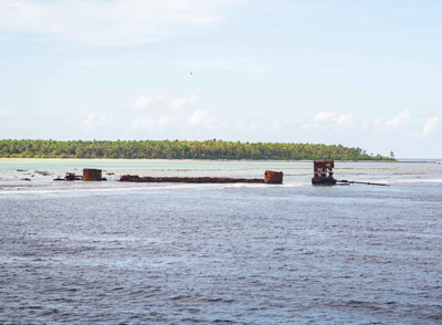
Today only the keel, the fuel oil tanks, and the ships giant triple-expansion steam engine survive on the reef surface. This photo was taken during the Niku VII expedition in July 2012. TIGHAR photo by L. Rubin.
|
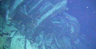
This screen capture from the high-definition ROV video shows what Norwich City wreckage looks like. As Jeff says, heavy bulky materials that are both close to and below the wreck.
|
|
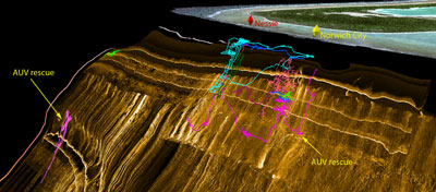
This map shows the tracks, known as “snail trails,” of all the ROV dives during Niku VII – each dive with its own color code. Two of the dives were for the sole purpose of rescuing the Autonomous Underwater Vehicle (AUV) when it got stuck on the reef slope. The one dive (green) at the northern extremity of the sonar map was to check out a prominent sonar target which turned out to be a large rock. The other dives were concentrated in the Norwich City debris field and in the area below “Nessie” (our tongue-in-cheek-name for the Bevington Object) where we expected to find aircraft debris. TIGHAR map by Phoenix International. Click on the image to open a much larger version in a new window. |
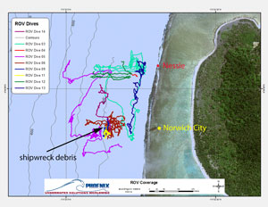
This map is an overhead view of the ROV dives that covered the primary search area. Click on the image to open a much larger version in a new window. |
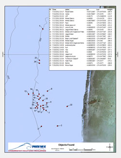 |
As shown in this map of Objects Found:
- In the Norwich City debris field, pieces of wreckage from the stern of the ship came to rest at depths between 59.6 meters ( 195 feet) – which is the base of nearly vertical cliff - and 280.3 meters (919 feet). Most of the wreckage is about 150 meters (nearly 500 feet) behind the wreck. There is also a scattering of debris at shallower depths and there may be more large pieces at greater depths.
- Nothing has been seen in the area between the two debris fields, either in the Standard Definition or the High Definition video except a hash pipe and a recent wine bottle.
- In the area behind Nessie, no debris was seen in the Standard Definition video except some rope or cable. Review of the High Definition video has now revealed a number of targets in this area, as described by Jeff Glickman above.
Click on the image to open a much larger version in a new window. |
|
As Jeff says, the Norwich City debris field is distinct in both appearance and location from the debris field behind the Bevington Object. For obvious reasons, we’re not releasing the exact location and depth of the objects currently under investigation.
Jeff also says, “Ric has recently proposed an alternate segmentation of the Bevington image that I support.” In the next update we’ll review the new segmentation of the Bevington image.
|

