|
Looking in the right place is, of course, the first requirement for a successful search, but with no contemporaneously documented witness to a crash we’re forced to rely on stories told and letters written years later by people who claim to have seen wreckage, or even recovered debris, presumed to be from the White Bird. Assessing the credibility of these tales is essential to knowing where to search because, no matter how dedicated the searchers or how sophisticated the technology, if you’re looking in the wrong place, you’ll come up empty-handed.
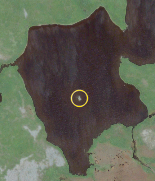
From 1984 to 1992 we chased stories that the White Bird had been heard to crash in the hills that rise to the west of Round Lake on the coast of Maine. Twenty expeditions found nothing but more stories. It wasn’t until we shifted our investigation to Newfoundland that we discovered anything that might reasonably be debris from a crash. We found it in the Gull Pond, one of many shallow bodies of water on the high muskeg barrens of the Cape Shore arm of Newfoundland’s Avalon Peninsula.
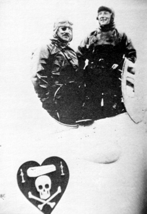
| Unlike Round Lake, there is solid contemporaneous documentation the White Bird was seen and heard near the Gull Pond. At a time when there were no aircraft in Newfoundland, at least eighteen witnesses, many of whom swore affidavits to local magistrates within days of the event, heard or saw an airplane as it flew southward down the Avalon Peninsula. In the north, Arthur Doyle saw a large white airplane coming in off the Atlantic Ocean. At the southern end, multiple witnesses in St. Mary’s saw an airplane flying westward over St. Mary’s Bay toward Red Head on the Cape Shore, apparently on fire. Whether the plane was trailing black smoke from a fire or white clouds of steam from a coolant failure is a matter of conjecture, but only these final witnesses described an airplane in distress.[1]
The archived contemporaneous witness statements are not folklore. They are independent primary-source accounts of events on the morning of May 9, 1927 reported soon afterward by people who did not know each other, nor did they know of Nungesser and Coli’s attempt to fly from Paris to New York until they read news reports in the days following the plane’s failure to arrive.
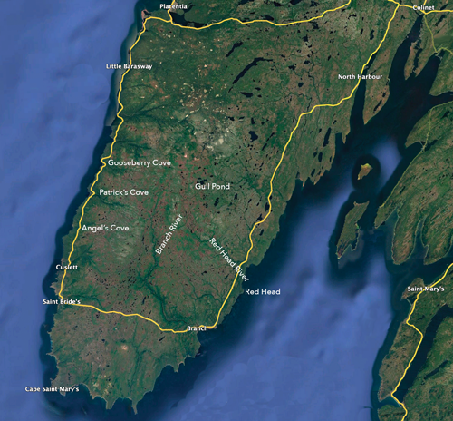
It can, therefore, be taken as fact that the White Bird made landfall in Newfoundland at Bacalieu Island around 9:15 on the morning of May 9, proceeded southward over Harbour Grace, Brigus, and Ocean Pond to St. Mary’s, and was last seen in distress, headed west, approaching or over the Cape Shore near a coastal prominence known as Red Head. There the contemporaneous written evidence ends.
That the White Bird crashed seven miles to the northwest at the Gull Pond is a possibility based on what can only be called a legend — a story based on multiple unauthenticated accounts of wreckage seen and/or recovered from the pond. Is the Gull Pond the best place to look for whatever may remain of the White Bird? To answer that question requires an objective evaluation of the constituent elements of the plane-in-the-pond legend assembled from dozens of interviews and a handful of letters — but first it is essential to understand the culture and context in which the legend was born and evolved. |
 |
The New Found Launde
The first European visitors to Newfoundland were Norse adventurers who established a settlement at its northern tip in 1021, but the Vikings didn’t stay. Nearly 500 years later, Italian explorer Giovanni Caboto, dubbed John Cabot by his employer King Henry VII of England, sailed into the harbor of what is today the city of St. John’s on June 24, 1497 — the feast day of St. John the Baptist. Upon his return to England, the Tudor monarch hailed the discovery of “new found launde.” The first permanent European settlers were English, Scots, Irish and French fishermen who arrived around 1610 to fish the vast schools of cod on the nearby Grand Banks. Newfoundland became a British colony in 1825 and in 1907 became a dominion of the British Empire and remained an independent member of the commonwealth until confederation with Canada in 1949. Today, the people think of themselves as Newfoundlanders first and Canadians a distant second.
The Cape Shore
Roughly thirty-five miles long by fifteen miles wide, the peninsula in the southwest corner of the Avalon Peninsula with Cape St. Mary’s at its southern tip is known as the Cape Shore. The handful of hamlets strung out along the one road that circles the peninsula are located at coves that once sheltered the dories of cod fishermen. The Cape Shore villages were first settled by Irish immigrants in the early 19th century and remain primarily populated by Newfoundlanders of Irish descent. To this day, many residents of some Cape Shore communities share a common surname. Just about everyone in Patrick’s Cove is a McGrath (pronounced McGraw) while the families who live in Angel’s Cove a few miles away are nearly all named Coffey.
 |
Until World War II, the area was relatively isolated from news of current events. In 1927 newspapers reached the Cape Shore only twice a week via horse drawn mail wagon, and the unpaved road was often impassable due to mud and wash-outs until 1941 when the newly-established U.S. Navy base at Argentia took over maintenance of the Cape Shore road. The first commercial radio station in Newfoundland did not begin broadcasting until 1932.
The interior of the Cape Shore peninsula is a high barren bog cut with stony streams and dotted with shallow ponds. Known locally as “the country,” the ground is muskeg — rocks covered with mats of dense soggy moss. People venture into the country only to trap beaver and muskrat, hunt grouse and caribou, or fish for trout.
A Pond By Any Other Name
A Google search of Gull Ponds in Newfoundland will yield dozens of results, but none of them is the Gull Pond of the Plane-in-the-Pond Legend. The pond is shown on topographic maps as Goose Pond, a name it was given by English surveyors in 1773, but this is the Cape Shore and pond names are fungible. Local people have little use for published maps and pond names are set by local tradition. To some, Goose Pond is “the Gull Pond.” To others, it is “the Branch Gull Pond” because it is the headwater of the Branch River, or “the Big Gull Pond” to distinguish it from three small surrounding ponds. Nobody calls it Goose Pond.
Click HERE for TIGHAR’s chronological reconstruction of events drawn from numerous interviews with multiple people who related sometimes conflicting versions of various parts of the legend. Most of the descriptions offered were recollections of incidents that occurred many years in the past. All should be recognized as stories that may or may not be true except for the few occasions when an event is documented in a contemporaneous written account.
|