On July 3, 2012 – the 75th anniversary of the U.S.S. Colorado’s departure from Hawai‘i on the Earhart search – TIGHAR’s Niku VII expedition sailed from Honolulu to conduct a search for the Earhart Electra in the waters adjacent to Nikumaroro. This is the hi-tech deep water search we’ve long wanted to do but could never afford.
To avoid
lengthy download times, the updates are divided into seven
day periods. This is the third week of the expedition. Date links refer
to U.S. days; Nikumaroro is on the other side of the date line, so it’s
tomorrow there, but the ship will keep U.S. dating so that there is slightly less confusion.
Reports
are in reverse date order so that those who check every day don’t have to
scroll down endlessly as the expedition progresses. If
you are new to this page, just click on the earliest date to the right (down
at the bottom of the list) and then scroll up to read each posting in order. For previous weeks, click on the “Week” links above.
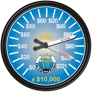
To make a donation to the Earhart Project, click HERE.
Please note that times and dates are, and will be, a bit confusing. All times are now being given in Z (UTC, Zulu, Greenwich) time as well as local time. The dateline is another matter and we are not going there. Suffice it to say that for mostly logistical reasons, the ship is arbitrarily staying on the U.S. side of the dateline. Ric calls on the satellite telephone each evening between 9 and 10 p.m. EDT. I write up the report and post it immediately. So each report will probably have elements from the previous day’s late afternoon, and that day’s morning work.
Dateline: Nikumaroro, 19 July 2012
02:00Z 7-19 (16:00 7-18 KOK)
Launched ROV to continue mowing the lawn in the primary search area.
04:00Z 7-19 (18:30 7-18 KOK)
Recovered ROV after completing two lines – 1,200 to 600 feet. We only go up the hill because it’s hard to see the surface going downhill. We are
not searching the vertical cliff that goes from 600 ft up to 250 feet.
06:00Z 7-19 (20:00 7-18 KOK)
Launched AUV for all-night mission to re-survey the primary search area and collect side-scan data south of Norwich City.
After discussion and analysis of the results so far, they have decided that there is very little point in extending the trip. The problem is the nature of the reef slope: a vertical cliff from 110 feet down to 250 feet, with a shelf that runs along that contour from Nessie to Norwich City. The airplane could have come to rest there briefly and lost pieces, but they have not found anything at all on that ledge.
From there the cliff goes almost vertically down to 1,000 – 1,200 feet, with another ledge. They will spend the rest of today searching that area. That is where the Norwich City wreckage came to rest, so maybe that's where the airplane stopped.
But the question of searching for an airplane in this environment is even more basic than “what ledge” or “how far down.” Given what we now know about this place, is it reasonable to think that an airplane which sank here 75 years ago is findable? The environment is incredibly difficult, with nooks and crannies and caves and projections; it would be easy to go over and over and over the same territory for weeks and still not really cover it all. The aircraft could have floated away, as well.
So for the time they have left, they will focus on the ledges. Nothing could stick to the cliff walls, they are far too steep for anything to stick; and besides, if you get something (like a tether) caught, you can cause an avalanche (they did) and lose your ROV (they almost did).
We have collected an enormous amount of data. We won’t know exactly how much, or what it all means, until it’s integrated and analyzed, but it is certainly of great value, not only to us but to anyone doing ocean and reef research in the area. We have no idea what might be discovered as we pull together all the pieces without the fog of war to distract us.
They head for Honolulu tomorrow.
Dateline: Nikumaroro, 18 July 2012
Yesterday’s rescue of the AUV involved hard throttle usage keeping the ship in position, and that caused a propulsion system failure that took six hours to repair. The afternoon was lost for searching, so Ric and TIGHAR cameraman Mark Smith went with the ship’s bosun in the skiff to check landing channel conditions. They found it to be in mid-tide on a rising tide with a
moderate swell – not great landing conditions but acceptable. Roughly 25
people availed themselves of the opportunity to go ashore.
By 04:30Z 18 Jul (18:30 17 Jul KOK) all the tourists were back aboard safely. Everyone was impressed with the island’s beauty.
This was a good break from the tension of underwater operations.
The ship’s propulsion system problems were repaired and were tested during the night. ROV search operations were resumed at 08:00 (KOK) with
a dive to locate and examine the promising target we couldn’t find yesterday. Analysis of the 17th’s AUV side-scan data showed yet another “strong Category 2” target in a different location.
The second target turned out to be a large coral boulder; everything with the AUV’s sonar turns on the exact angle as it flies past, and it’s tough to program in repeated passes when you don’t know what’s there or what might be there. In fact, the AUV did not see any of the Norwich City wreckage on the first several passes – it required a completely different angle and approach and suddenly the great mass of crumbling steel appeared.
The other target, after much work and discussion, was finally decided to be a piece of the Norwich City’s keel, much degraded and skeletonized. Now they are going back to the “mowing the lawn” approach, a visual search which is more discriminating and more accurate at acquiring targets than the side-scan in this environment. The hope is that they will pick up a debris field and be able to follow a trail, as it were – much like was done to find the Titanic. But it is, of course, possible that the aircraft floated for some time and drifted out to sea. If that is the case, it is not too likely that any small parts will be found. But they are far from done, and the possibility of extending the trip for one or two days to compensate for the lost time due to equipment problems is also being discussed.
Dateline: Nikumaroro, 17 July 2012
We have a saying at TIGHAR, all too often used – “Adventure is what happens when things go wrong.” There were some adventures today.
The AUV was hung up underwater for four hours last night. It freed itself and continued the mission but got stuck again as it was ascending for recovery at a depth of 722 meters (2,368 feet), west of the island’s NW tip.
Option 1:
Leave the AUV where it is for now, go search for the target identified yesterday with the ROV, and come back this evening to recover the AUV with the ROV if it hasn’t freed itself by then.
Risks to Option 1:
The good navigation beacon is on the AUV so we would have to do the target search using the marginal navigation beacon.
If the AUV frees itself during the day and comes to the surface and they lose radio contact with it, we could end up searching for it visually. Not good.
Option 2:
Immediately go after the AUV with the ROV.
Risks to Option 2:
The ROV will have to use the marginal navigation beacon – but that is also true of Option 1.
The 722 meter (2,368 feet) depth is near maximum for the ROV.
18:30Z (08:30 KOK)
We made the decision to go for Option 2 and began preparing the ROV for the rescue mission. We’ll lose the morning for search operations but we’ll run the ROV into the night if need be.
21:30Z (11:30 KOK)
The rescue mission was successful – but it was a real cliff-hanger. Operating literally at the end of our tether, we searched for over an hour in nightmare terrain: a vertical cliff face pockmarked with caves and covered with fern-like marine growth. We finally came across the AUV wedged cross-wise (parallel parked) in a narrow cave. Wolfgang flew in and used the claw to gently grab a handle near the stern of the fish. He then pulled the AUV out of the cave and well clear of the cliff face before releasing it to float to the surface. Once the ROV and AUV are recovered aboard, we’ll reposition and try again to find yesterday’s promising sonar target.
The above directly from Ric in an email. When he called, he was about to take a small party ashore, because the recovery of the AUV and the maneuverings required had strained something in the ship’s power train which would take some hours to fix. By nightfall they expect to have ROV in the water again and will operate through the night if necessary.
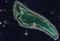
Meanwhile, our very generous sponsor GeoEye has provided us with a new satellite image, taken on July 12. Click on the little photo to open a new page with a much larger image.
Dateline: Nikumaroro, 16 July 2012
It’s been a frustrating and crazy day today.
During the night the AUV collided with the bottom, squashing the nose cone. They have a spare, it’s been installed, no harm done, but it still uses time and resources better spent elsewhere.
They were late getting the ROV in the water due to technical difficulties – a 10:30 a.m. (local) launch. Once it was in the water, they found that the signal from the HD camera was erratic, so they had to bring the ROV back aboard to switch out the camera. More lost time. Then, just as they were ready to launch, the boat developed a problem with the remote throttles used for control while the equipment is in the water – another two hours getting that sorted.
Meanwhile, they were processing the data from the night’s AUV run and found a quite good target, maybe a 1 and a half. It was in close to the reef and also close to Norwich City wreckage, so it’s a very difficult environment for the ROV, quite dangerous in fact. It may just be a freak piece of Norwich City, but they can’t ignore it, so the AUV team is working on refining the navigation data and the ROV team is continuing to work very cautiously in a treacherous environment.
All in all, frustrating and crazy. Tomorrow the plan is to simply “mow the lawn” with the ROV, using Mark I Eyeballs to survey the search area in a systematic way, only looking for specific targets identified by the AUV if they are very hot and very likely.
Dateline: Nikumaroro, 15 July 2012
They are learning a lot about the reef slope. It’s a lot more demanding than we knew or even imagined.
Immediately offshore the reef edge in the primary search area the reef slope drops away in an essentially vertical cliff hundreds of feet tall. Coral outcroppings on the steep slope tend to snare the ROV tether, forcing the pilot to back-track to free the snare. Further out and deeper, the slope moderates somewhat. Except for some Norwich City
debris, no man-made objects were seen in two 60-foot search swaths from 21 meters (70 feet) down to 365 meters (1,200 feet). There are,
however, many flat coral surfaces with right angle corners resulting in numerous false alarms.
At 03:45Z (17:45 KOK 7/14) the ROV was launched for a second mission. Immediately after deployment, and while the ROV was still close to the ship, the generator powering the entire ROV system failed, causing a blackout of all propulsion, video, and positioning telemetry.
There was great concern that the ROV tether might
run afoul of the ship’s propellers before power could be restored, but the ship maneuvered clear of the tether and the ROV was soon recovered
safely aboard. The second mission was cancelled and the generator problem was addressed – a dirty fuel filter.
At 05:30Z (19:30Z 7/14 KOK) the AUV was launched for an all-night side-scan mission to cover the southern half of the primary search area at depths similar to last night and
will then try to cover some of the shallower, more hazardous, portions of the northern half.
At 07:30Z (21:30 7/14 KOK): at last report the AUV was running well.
At 10:30 7/15 (KOK time; conversion to follow as an update), the ROV was back in the water with the generator working reliably. There was some delay because the AUV ran successful missions all night, collecting much more data, which is now being proceesed and plotted. Now that there are targets plotted by the AUV, they need to be ground-truthed with the ROV.
They did look at three targets, which all turned out to be coral blocks. There is a learning curve here as the technicians become familiar with the environment, understanding what is normal/usual/natural and what doesn’t fit and may in fact be man-made.
One big question has been, “Where is the aft end of the Norwich City?” To answer that question, they started looking with the ROV at about the 1600 foot depth, working in towards the shipwreck. At about 1050 feet they found old fashioned bottles. At 1000 feet they found a ship’s propeller, a huge (8 feet across), four-bladed, apparently iron or steel, prop with squared-off blades. At 980 feet they found the main body of the wreckage, a huge towering hunk of bent and twisted steel and iron. They took plenty of time to look at it and make sure there wasn’t any silvery sheet metal lurking around it, and took multiple fixes to be sure it’s identified in space very accurately.
No man-made debris has been found in the primary search area but there is still a lot of ground to cover. The weather is holding good, the sea is calm, which makes working the technology much easier.
Everyone was hoping for a quick find, but of course it is the slow solid approach that works.
On the primary monitor in the Phoenix lab, the one that keeps track of the fish, there is a hand-printed sign: “Worst Environment Imaginable.”
Dateline: Nikumaroro, 14 July 2012
The AUV was out all night (the 13th/14th) and collected a lot of data. They’ve spent the day processing it and there are a number of Category 2 (Really Good) targets that the techs feel sure are manmade. The new system is working very well: work down the reef slope collecting data; go straight up; work down again – think skiing, you ski down and take the lift up.
The ROV went in the water at 09:45 local (19:45 Z) for a six hour mission. (ROV missions are six hours because that is how much storage there is on the HD video camera.) At the end of the six hour mission they decided to leave it in for a while and continue searching. During that additional search time, the tether got wedged between a rock and the cliff face, and they couldn’t get it untangled, even using the manipulator arm which developed a problem with the hydraulics in the process. So they brought the ROV back up (this event was at 312 feet), and they’ll send it back down, having fixed the manipulator arm and changed out the camera, untangle the tether, and continue the mission until sunset or thereabouts. Then they’ll put the AUV back down. (The two technologies can’t run simultaneously because the ship has to follow the AUV.)
It’s tedious work watching the ROV feed. Your eye sees things and wants to make sense of them in a human way, you look at coral and rocks and your eye tries to interpret them as People Stuff. It’s dark in the Can, and there’s only just so much WOW factor in endless streaming video of coral and cliff-face and rocks. They are surveying the reef slope off the “Nessie” location in 60 foot swaths from 70 feet down to 1200 feet. It’s very steep and very clean; any manmade object will be very significant. The weather is good, seas calm, and that allows them to stay stable and close in to shore, which is a big help.
Dateline: Nikumaroro, 13 July 2012
From Ric aboard K-O-K, via email:
02:00Z 7-13 (16:00PT 7-12 KOK)
ROV test to 800 feet. Spotted a target with the ROV’s sector-scan sonar, maneuvered to it and identified it with video – piece of Norwich City debris roughly two feet long. Excellent proof-of-concept. AUV is repaired. Prop was not turning on prop shaft. Ready to deploy on another test as soon as ROV is recovered.
02:30Z 7-13 (16:30 KOK)
AUV launched on 4-hour test mission along reef slope. If this mission is successful they'll re-program for a 12-hour all night mission.
03:15Z 7-13 (17:15 KOK)
AUV is stuck or hung-up on the reef slope off the mouth of Tatiman Passage at a depth of 1,604 feet. Mobilizing for rescue attempt with the ROV. ROV must be configured for deep mission.
06:00Z 7-13 (20:00 KOK)
ROV launched for rescue attempt and begins descent.
06:30Z 7-13 (20:30 to 21:30 KOK)
ROV unable to locate stuck AUV but, in the process of searching, the ROV's tether apparently knocked the AUV loose and it appeared on the
surface.
09:00Z 7-13 (23:00 KOK)
AUV and ROV recovered aboard.
The end of the work day assessment was:
Objective: Collect SeaBeam mapping data
Accomplished except for last grid line close to reef edge.
Assessment – System provides good general picture of reef morphology. No surprises so far. The sonar map confirms what we already knew. The
reef slope is extremely steep. The 3-D graphics are spectacular but, as expected, not detailed enough to guide actual search operations.
Objective: Test AUV
Accomplished
Assessment – Based on today's operations, the AUV may not be an appropriate search tool for this environment. Final decision tomorrow.
Objective: Test ROV
Accomplished
Assessment – The ROV appears to be an effective tool for searching a closely-defined area.
Further work with the AUV has resulted in a system that will work very well. The AUV will fly down the reef slope collecting data; at the end of the downward run, it will drift back up (vertically) rather than attempting to fly up and collect data on the upward run. The imagery being collected is excellent; in fact, there is already a Category 2 (Interesting) target for the ROV to look at, something about 2m x 6m, with some right angles.
So the ROV team will run during the day, doing visual searching and looking at anything the AUV has found; and during nighttime hours, the AUV will run according to the above patterns. As we spoke the AUV was about to go back in the water for another run of final tests, but the system looks good.
Our special thanks to the corporate
and individual sponsors of The Earhart Project, without whom nothing would
be possible:
photekimaging.com
digitalglobe.com
markertek.com
thursby.com
sibfla.com
journeysaviation.com
lehightesting.com
whiteselectronics.com
The Members of the TIGHAR Board of Directors.
And the loyal membership of TIGHAR.
The
Earhart Project is funded by charitable contributions. Donations by check
(payable to TIGHAR) or credit card (Visa, Discover, or Master Card) may be sent to TIGHAR,
The Earhart Project, 2366 Hickory Hill Road, Oxford, PA 19363 USA, or click on
the link above to make your contribution. Confidential inquiries regarding
sponsorship opportunities for individuals or corporations should be addressed
to Executive Director Richard Gillespie (email Ric@tighar.org).
Copyright 2021 by TIGHAR, a non-profit foundation.
No portion of the TIGHAR Website may be reproduced by xerographic,
photographic, digital or any other means for any purpose. No portion
of the TIGHAR Website may be stored in a retrieval system, copied,
transmitted or transferred in any form or by any means, whether electronic,
mechanical, digital, photographic, magnetic or otherwise, for any purpose
without the express, written permission of TIGHAR. All rights reserved.