On July 3, 2012 – the 75th anniversary of the U.S.S. Colorado’s departure from Hawai‘i on the Earhart search – TIGHAR’s Niku VII expedition sailed from Honolulu to conduct a search for the Earhart Electra in the waters adjacent to Nikumaroro. This is the hi-tech deep water search we’ve long wanted to do but could never afford.
To avoid
lengthy download times, the updates are divided into seven
day periods. This is the second week of the expedition. Date links refer
to U.S. days; Nikumaroro is on the other side of the date line, so it’s
tomorrow there, but the ship will keep U.S. dating so that there is slightly less confusion.
Reports
are in reverse date order so that those who check every day don’t have to
scroll down endlessly as the expedition progresses. If
you are new to this page, just click on the earliest date to the right (down
at the bottom of the list) and then scroll up to read each posting in order. For previous weeks, click on the “Week” links above.
To make a donation to the Earhart Project, click HERE.
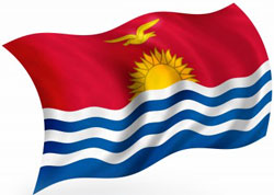
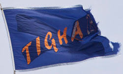
Last night at sunset I hoisted the TIGHAR banner on KOK’s starboard halyard. On the port halyard I raised the national flag of Kiribati. The swallow-tailed TIGHAR flag – technically a “burgee” – bears the old TIGHAR logo in orange on a blue background. It has flown on every TIGHAR expedition to Nikumaroro since our first trip in 1989 and is now a bit tattered. Out of respect, we only fly it now upon departures and arrivals.
11:30Z (07:30 EDT, 01:30 KOK)
KOK arrived off NW tip of Nikumaroro. Sea calm, scattered clouds, light easterly winds.
12:00Z to 17:30Z (02:00 to 07:30 KOK)
SeaBeam system collected mapping data in search box and along southern coast of atoll. Mapped all of search box except last line close to reef – to be done in daylight.
18:40 to 19:40Z (08:40 to 09:40 KOK)
Launched and ballasted AUV.
20:30Z (10:30 KOK)
SeaBeam data processed. Impressive three-dimensional maps of steep reef slope. AUV began its 4-hour initial test run.
21:15Z (11:15 KOK)
AUV test run aborted. AUV not behaving as programmed.
22:30Z (12:30 KOK)
AUV re-programmed for another test run.
23:00Z (13:00 KOK)
AUV still not working right. Keeps returning to the surface.
00:00Z 7-13 (14:00 KOK)
Decision to recover AUV. Suspect problem with propulsion vectoring system. While AUV is back aboard we’ll run tests on the ROV.
By the time Ric called at 2115 EDT time the problem was diagnosed: the prop shaft was turning but the prop was not. Perfectly fixable, and while those repairs were under way they launched the ROV for tests. The ROV will be tested over the Norwich City debris field which should be extremely interesting. Our phone call had to be cut short so he could go into the cab and participate in the tests. Everyone is absorbed in problem solving and testing and there is no chatter, no idle watching of the birds; get the equipment running and get to work is the mantra.
Photo credits: TIGHAR Burgee photo by Jason Baker. Kiribati flag 123RF stock image. AUV TIGHAR photo.
Dateline: At sea, 11 July 2012
Housekeeping: Beginning with the 12 July update, times will be offered in local and GMT. This should help everyone figure out what time it is for where they are.
Anecdote: When a British government official visited Nikumaroro in the 1950s, he was a bit confused about why his watch always seemed to be wrong. Then he discovered that the servant in the guest house set all the clocks to 6 a.m. at sunrise every morning. Worked for them!
Position: They should pass about 10 miles east of McKean at around 1815 local time, just before sunset. Since they will be looking into the setting sun it’s unlikely they’ll see the island (max. elevation about 3 meters), but they will certainly see birds and may well smell the island if the wind is setting that way. One million birds make a lot of guano.
They’re within 100 miles of Nikumaroro. Current ETA, 1:30 a.m. local time.
When they arrive they will immediately start working the primary search area with the Multi-Beam to map the ocean bottom. Ric will be on the bridge to give local knowledge to the Captain – what is where, what that shadow is, and so on. There will be very little moon (last quarter) and they will be relying heavily on radar and that local knowledge to work the edge.
That will take about two hours; then they will do a perimeter sweep of the island to get a general sonar map, arriving back at the primary area at daybreak.
The AUV will go in the water for a& four hour test in the search area. When it returns for download and to have new programming and batteries installed, the ROV will go in for a two hour test run. Then the AUV will go back down for the first “real” run of the expedition, eight hours of data collection.
The atmosphere aboard is rather like the mood aboard an LST as it approaches an island the troops have to take. They are going into action soon; all “weapons” have been cleaned and checked and rechecked, plans refined and massaged. There is a palpable sense of pressure and stress, but in a good way; everyone is impatient to get started with the mission.
Ric has been going back through all the original source materials to be sure all the details are fresh and accurate in his mind, however complicated; there have been a lot of sound-bite compressions of complex stories the last few months, and having the real information uppermost is essential.
There is a lot of pent-up energy ready to explode into action when they arrive.
Dateline: At sea, 10 July 2012
Actual position at Hawai‘i time 13:49:53, 00°00′ N, about 170° W. The pool was won by a member of the K-O-K crew, who put in 13:50:08. Not bad!
Nothing much happening, of course. Right now it’s a matter of waiting for the world to turn under them, listening to the drone of the engines, looking out for birds (which indicate land within 200 or so miles), and polishing plans.
They may pass close enough to McKean Island to see it, which is well worth noticing. The clouds of birds are unbelievable; the Smithsonian counted (counted!) one million birds there twenty years ago, and it certainly has as many now.
One more day of just traveling, and they expect to arrive very early Thursday morning and begin work.
Dateline: At sea, 9 July 2012
Actual position at 2100 EDT, 2°55′ N, 169°47′ W, with 536 miles to go, making 8.6 knots.
Tomorrow’s excitement will be crossing the Equator, estimated at between 2 and 2:30 shipboard time. They are starting a pool to predict the exact time; prize: One TIGHAR ball cap. Well, it breaks up the monotony.
They should arrive at Nikumaroro in the wee hours of Thursday, July 12, local time. They will begin immediately to map the primary search area with the Multi-Beam; if it’s still dark when they finish that, they’ll do a lap around the island (about two hours) to generate a general profile of the reef.
As soon as the sun is up the AUV will go in the water for a four hour mission to check systems and data acquisition. They may use the Norwich City, or may use the primary search area; that decision will be made according to the situation and the weather.
When the AUV is recovered, they’ll launch the ROV for its test mission, again a short spell just to be sure all systems are working correctly.
Once the AUV has its data downloaded and the batteries swapped out, it will go back in the water for an eight hour mission to begin the serious search. The ship will shadow it, and they’ll be working the data as it comes off each mission. Hurry up and wait....
Dateline: At sea, 8 July 2012
Actual position at 2100 EDT, 5°55′ N, 167°54′ W. About 750 NM to go.
More work today on the ROV footage from 2010, making sure they know everything they can know about what is there, what “normal” looks like, and training their eyes so that – it is to be hoped – anything that doesn’t “belong” will pop out at them. Long tedious days, waiting for the world to turn under them at 9 miles per hour. Still anticipating landfall at Nikumaroro about midnight on July 11.
Email is up again after passing through a long dead area. Emails are sparse, concise, very compressed, and shot out once per day. Not exactly a social medium, but it does help when there are specific questions to be answered.
Dateline: At sea, 7 July 2012
Actual position at 2100 EDT, 9°4′ N, 165°53′ W, making 9.2 knots. 974 miles to go, so roughly halfway.
They spent today digging into the ROV footage from 2010, correlating all the data points and finding out they knew a lot more than they thought they knew. Although (due to equipment problems in 2010) they can’t pinpoint locations, the can narrow it down a lot. Combined with sonar data and soundings taken over the decade, there is a lot of information there. The ROV technician, Wolfgang Burnside, is seeing things in the footage that he wants to look at very closely. The main task now is to pull all the data together: video, remarks from the technicians, placement data, soundings, sonar, all of the information that has been gathered over the decades, and put it all together in a coherent picture that can be used as a starting point when they are on site.
When the ROV is down feeding video to the surface, Ric and Wolfgang will be watching in the van, but the video will also be remoted to all the flat screens throughout the ship for anyone to watch. So instead of relying on only two sets of eyeballs, everyone will be able to see what the ROV is seeing, a great advantage.
The different teams aboard – TIGHAR, ROV, AUV, K-O-K, and so on – are learning to work together and complement each other. Enthusiasm is high and everyone is ready to hit the ground (ocean?) running on the 11th.
Dateline: At sea, 6 July 2012
Actual position at 2200 EDT, 12°4′ N 163°58′ W making a 9.2 knots. Weather is good with a typical scattered deck of cumulus clouds at est. 1,500 feet. Seas are eight to ten foot swells.
Ric did a PowerPoint background presentation for anyone who wanted to see it, which was everyone who wasn’t on duty; the ship’s crew and the technical staff haven’t had much of a chance to get into the whys and wherefores of the case and were very interested. He’s doing it again tonight for anyone who couldn’t see it this afternoon. Otherwise, there are constant meetings to work out the schedule, fill everyone in on the technical environment, and get everyone’s comments and suggestions about the best way to proceed.
At this time the estimated arrival on site is just before midnight July 11, but of course this is subject to change as weather, wind, sea state, and so on combine in different ways.
Later today there will be a holding position exercise to give everyone a feel for how accurately the ship can stay in one place. This will be a general idea, of course; the exact conditions that may exist at any moment at the island will necessarily be different from the conditions in the open sea. Still, even a general indication will help the ROV technicians fine-tune their plan, since they will be “live-boating” the ROV: swimming the equipment from a ship that does not have the technology to hold an exact station based on GPS positioning. It shouldn’t be a problem, but they are looking for data points to improve the programming.
There is still an awful lot of blue water out there between K-O-K and Nikumaroro.
Our special thanks to the corporate
and individual sponsors of The Earhart Project, without whom nothing would
be possible:
photekimaging.com
digitalglobe.com
markertek.com
thursby.com
sibfla.com
journeysaviation.com
lehightesting.com
whiteselectronics.com
The Members of the TIGHAR Board of Directors.
And the loyal membership of TIGHAR.
The
Earhart Project is funded by charitable contributions. Donations by check
(payable to TIGHAR) or credit card (Visa, Discover, American Express or Master Card) may be sent to TIGHAR,
The Earhart Project, 2366 Hickory Hill Road, Oxford, PA 19363, USA, or click on
the link above to make your contribution. Confidential inquiries regarding
sponsorship opportunities for individuals or corporations should be addressed
to Executive Director Richard Gillespie (email Ric@tighar.org).
Copyright 2021 by TIGHAR, a non-profit foundation.
No portion of the TIGHAR Website may be reproduced by xerographic,
photographic, digital or any other means for any purpose. No portion
of the TIGHAR Website may be stored in a retrieval system, copied,
transmitted or transferred in any form or by any means, whether electronic,
mechanical, digital, photographic, magnetic or otherwise, for any purpose
without the express, written permission of TIGHAR. All rights reserved.


 Last night at sunset I hoisted the TIGHAR banner on KOK’s starboard halyard. On the port halyard I raised the national flag of Kiribati. The swallow-tailed TIGHAR flag – technically a “burgee” – bears the old TIGHAR logo in orange on a blue background. It has flown on every TIGHAR expedition to Nikumaroro since our first trip in 1989 and is now a bit tattered. Out of respect, we only fly it now upon departures and arrivals.
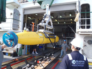 18:40 to 19:40Z (08:40 to 09:40 KOK)