If Earhart and Noonan, died on Nikumaroro, where
is the Electra? The short answer is, we don’t know. We can, however, make a few logical
deductions about where it can’t be and where it might be.
 |
If any of the nearly two hundred radio distress calls
that were heard for at least four nights after the disappearance
were genuine – and about half of the reported signals do
seem to have been genuine – then the aircraft had to have
made a relatively safe wheels-down landing and been able to run
an engine to recharge the batteries. |
 |
|
That means the distress calls could not have been sent if the
plane landed in the lagoon or the ocean. |
|
Had the airplane landed on the beach or in any of the atoll’s
few open areas it should have been discovered by the Navy’s
aerial search, later island inhabitants, or TIGHAR’s searches. |
|
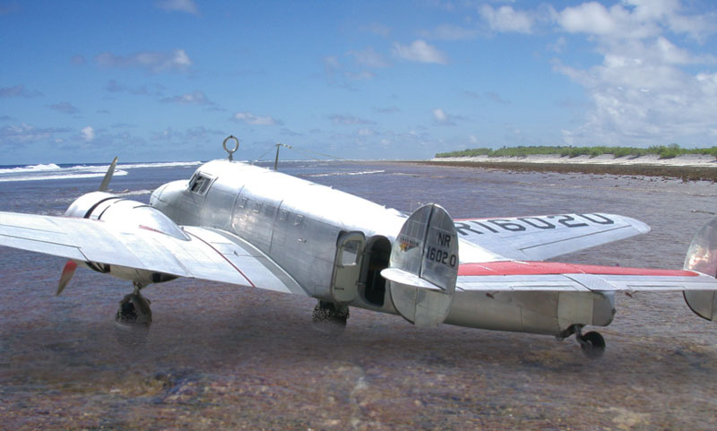
That leaves as the only alternative the atoll’s fringing
reef, which dries at low tide and is smooth enough in some places
to land an airplane. |
| Could the Electra have landed on the reef at Nikumaroro? |
|
The island is on the navigational line Earhart said she was following
in the last in-flight radio transmission heard by Itasca. |
|
They should have had more than enough fuel to get there. |
|
The tide was low and the reef was dry during the time they could
have arrived. |
|
The reef is smooth enough in places to permit a safe, if bumpy,
landing. |
| Are there any clues that the airplane was landed on the reef
at Nikumaroro? |
|
The times when credible radio distress calls were heard over
the next four nights correspond with times when the water level
on the reef at Nikumaroro was low enough to provide enough prop
clearance for an engine to be run. |
Click on the map to open a much larger version in a new window.
|
|
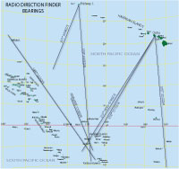
Directional bearings taken by Pan American and the U.S. Coast
Guard on radio signals believed to be sent from the missing plane
crossed in the vicinity of Nikumaroro. |
|
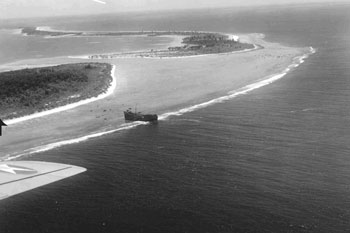
By the time Navy search planes flew over the island
a full week after the disappearance, the credible radio calls had
stopped. The pilots and observers saw “signs of recent habitation” on
the officially uninhabited atoll but no aircraft. A photo
of the island taken during the Navy search shows that the tide
was high with significant surf on the reef edge. If there was an
aircraft there it was hidden by the surf. |
| Is there any evidence that the plane was there and, if so, where? |
| Date: December 1, 1938 |
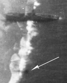 |
| Source: Photograph |
|
An aerial photo taken as part of the New Zealand Survey shows
what appears to be an anomaly just below the surface on the
reef edge just north of the shipwreck. The sea was calm with
minimal surf on the reef. |
|
| Date: Sometime between January 1940 and November 1941 |
 |
| Source: Anecdotal recollection in 1999 TIGHAR interview |
|
Emily Sikuli (née Segalo Samuela), teenage daughter of the island’s carpenter Temou Samuela, saw debris that her father told her was airplane wreckage on the reef edge at low tide about 100 meters north of the Norwich
City shipwreck. |
|
| Date: 1942 |
 |
| Source: Photograph |
|
An aerial photograph
shows the effect of severe weather that struck the island in
January 1939. At that time the stern of Norwich City separated
and tumbled down the reef slope into deep water. Other debris
from the shipwreck was scattered shoreward. The photo shows
no sign of the anomaly seen in the 1938 photo. |
|
| Date: 1944 |
 |
| Source: Anecdotal recollection in 1995 TIGHAR interview |
|
U.S. Navy PBY pilot
John Mims saw island residents using an airplane control cable
as a fishing line leader for large fish. When he asked where
they had gotten the cable the islanders said there was an airplane
wreck on the island when the first settlers arrived in 1939.
When he asked where the wreck was they said they didn’t know. |
|
| Date: Sometime between 1946 and 1963 |
 |
| Source: Anecdotal recollection in 1997 TIGHAR
interview |
|
Island schoolteacher
Pulekai Songivalu saw airplane parts on the lagoon shore opposite
the main passage. The parts were salvaged by island residents
for local purposes. |
|
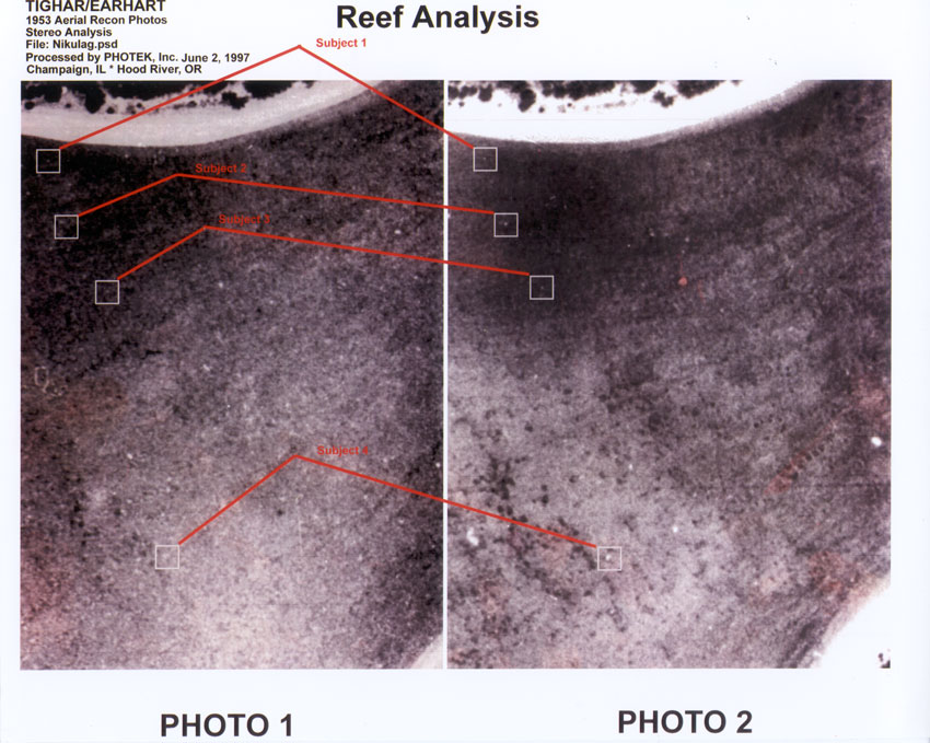
| Date: 1953 |
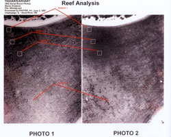 |
| Source: Photographs |
|
Forensic imaging
of two aerial mapping photos shows what appears to be a debris
field of four pieces of light colored metal roughly 4 feet
square on the reef flat downstream of the possible wreck site.
(Click on the photo to open a much larger version in a new
window.) |
|
| Date: Sometime between 1958
and 1963 |
 |
| Source: Anecdotal recollection in 1997 TIGHAR
interview |
|
Tapania Taeke,
between 5 and 10 years old, saw a piece of an airplane wing
on the reef in roughly the same area as the debris field
in the 1953 photos. |
|
| Date: November 1991 |
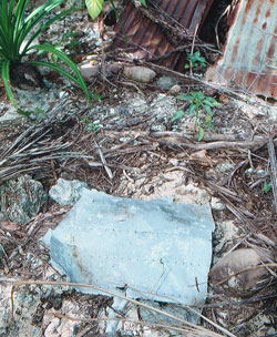 |
| Source: Artifact |
|
TIGHAR’s second expedition to Nikumaroro
found a section of badly torn aluminum airplane skin that
appeared to have been washed ashore in a severe storm that
had struck the island since our initial visit in 1989. Whether
the artifact could be from the Electra is the subject of
intense controversy but the circumstances of its discovery
strongly suggest that it came from the sea and was flung
ashore by the storm. |
|
| Date: June 2002 |
 |
| Source: Anecdotal recollection in 2002 TIGHAR
interview |
|
During a New
England Aquarium marine biology expedition to the island
in 2002, the expedition leader, Dr. Greg Stone, saw a wheel
(no tire) near the shore in the main lagoon passage that
looked to him like it might be an airplane wheel. Greg was
familiar with TIGHAR’s work and, because the wheel
was so easy to see, he assumed that TIGHAR had examined it
and dismissed it. Only after leaving the island did he learn
that we had never seen such an artifact at Nikumaroro. After
close questioning, his description of what he saw sounded
right for a wheel from the Electra so we mounted a special
expedition in 2003 to see if we could re-locate it. Unfortunately,
in the interim, more storms had devastated the west end of
the atoll and the object that Greg Stone had seen was gone.
MORE |
|
Where
is the Electra? Connecting
The Dots What
Might We Find? |