|
Ric has talked
by email and phone with Greg Stone and it seems we’re still in the
game. Here is the email exchange:
Hi Greg,
I know you're in Bermuda
until August but I hope you can get email.
Our team arrived at Niku
yesterday and tried to find the object you described for us. Looking
in the area you indicated, all they found was the reinforcing
ring from a 55-gallon oil drum.
There are a few things
about the barrel ring that fit your description:
- it is visible from
shore
- it is about 20 feet
out
- it is stuck to the
bottom
- it is covered in
marine growth
There are other things
that definitely don't fit:
- You were sure that
the wheel rim stood about 15 inches off the bottom. The barrel
ring stands about 2 inches off the bottom.
- You were sure that
the diameter of the wheel rim was about 12 inches and that you
reached down into the water with both hands to try to pick it
up. The barrel rim is easily twice that diameter and you probably
wouldn't reach down with both hands to try to pick it up.
- You said that the
wheel rim was not rusty. The barrel ring is, of course, very
rusty.
Are you familiar with
these rings? They're the heavy rims that go around the top and
bottom of metal drums. Typically the thin metal of the drum itself
rusts away leaving only a rim. We see lots of them on Niku.
What do you think are
the chances that this is what you saw?
Hi Ric, That is definitely
not what I saw--I seem to remember vaguely, some old 55 gal rims
as you describe, what I saw, as you describe, was well above the
sediment and was not rusted, just mildly encrusted. It WAS a wheel
rim--whether a plane wheel rim or an automobile or some other
wheel rim is the question. Your analysis of the discrepancies
is absolutely accurate. From what you say, they have not found
what I saw. Have they tried a metal detector? I do not know what
to say except, that they should keep looking.
Ric
phoned Greg and they talked for quite a while. He is dead certain
that what he saw was not a barrel ring. In trying to pin down the
location closer he remembered that the National Geo photographer
and Rusi (a crew member from Nai’a) were trying to get a
good picture of a coconut crab at the base of a palm that grew out
over the water. He is sure that he saw the wheel between that tree
and the lagoon and it was out of sight of the tree.
There is only
one tree that fits that description – Shark Tree – and it is much
further along in the passage than he had originally thought. By
coincidence, National Geo is going to use that photo of the crab
and the tree as the lead photo in an article about Greg’s expedition
that they will run next April. Greg has a low-res copy of the photo
with him now in a draft of the article he is reviewing. He can’t
send me the photo but we sent him the photo we have of Shark Tree
(in yesterday’s update) to confirm that we’re talking about the
same tree. He will look at it tomorrow morning.
Van checked
in yesterday evening about 20:00 EDT, about 14:00 there. (He took
the satphone ashore with them.) Ric was able to bring him up to
date on all of the above. They’re surveying their way along the
shore toward the blasted channel. They’ll now head back up the coast
and start searching from Shark Tree toward the lagoon. Maybe tomorrow’s
report will bring better news.
Ric also spoke
briefly
with John Clauss, who has spent more time on Nikumaroro than anyone
except Ric. He says the place was hit hard last winter and is very
green now, probably indicating higher than normal rainfall. He also
thinks the fish and bird populations may be down somewhat but it’s
hard to be sure.
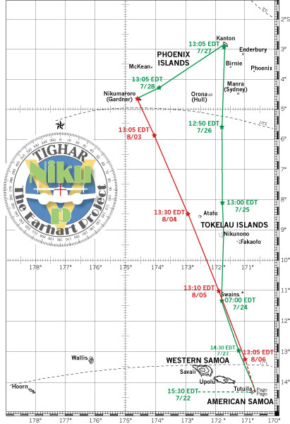
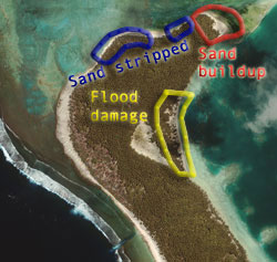
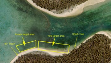 When
Van made his morning report today we talked at length about where
to continue the search for the WoF. The photo at right shows the
area we decided should be the new target area. The reasoning goes
like this: When
Van made his morning report today we talked at length about where
to continue the search for the WoF. The photo at right shows the
area we decided should be the new target area. The reasoning goes
like this:
- Greg says
there is a distinctive palm that grows at a 45 degree angle out
from the treeline. (This is not Shark Tree that grows out at almost
a 90 degree angle.) He has a recollection that you can see Norwich
City from that spot. After studying the satellite photos Ric
thinks the tree marked on the photo is probably the one he's talking
about – but that’s just a guess. Van is going to check it out
on the ground.
- Greg left
the Nat’l Geo photographer and Rusi trying to get a good photo
of a coconut crab at the base of that tree, and he walked along
the shore toward the lagoon.
- Greg saw
the wheel after he was out of sight of the 45 degree tree.
- Greg does
not remember Shark Tree which suggests, but does not prove, that
he never got that far.
- The area
shown in the New Target Area box would seem to be the most likely
place. Note that there’s a cove right there that appears to collect
sand. Van knew just where we were talking about and he says that
it is sandy in that area now. We discussed the possibility that
an object a few feet out into the water in June 2002 could now
be on shore and under the sand due to a building outward of the
shoreline. Today he and John will search the new area both in
the water and on land with metal detectors.
Meanwhile,
Howard and Walt will return to Norwich City at low tide later
today to finish taking measurements.
They had a
pretty good squall go through last night and Mollie dragged
her anchor. They pulled it in and drifted most of the night. It’s
cloudy today and they may get rained on.
Everyone is
in good health. Howard, like most rookies, had to climb the Niku
learning curve the first day. He is now being more careful about
sunglasses, sunblock and drinking lots of water.
|


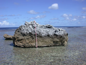 This
photo shows one of the coral blocks we’re talking about. The red
and white stick is two meters long – over six feet. The storm
waves are so fierce that they break off huge chunks of the reef
and throw them up onto the reef-flat. No problem for them to clean
off a few airplane parts.
This
photo shows one of the coral blocks we’re talking about. The red
and white stick is two meters long – over six feet. The storm
waves are so fierce that they break off huge chunks of the reef
and throw them up onto the reef-flat. No problem for them to clean
off a few airplane parts.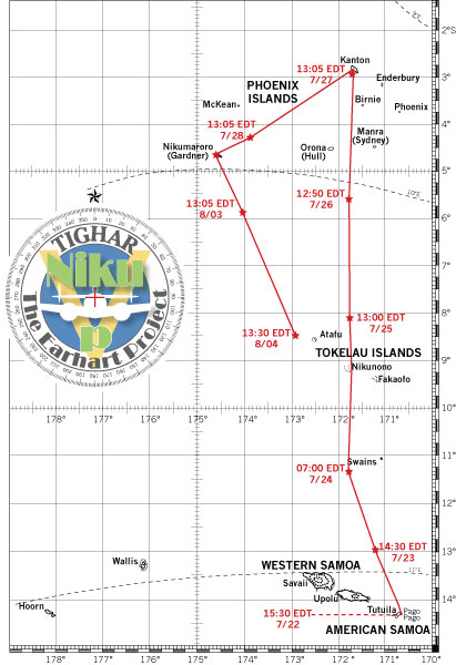
 We’ll
want to look at the weather for the past year and see if we can
find the storm that was the culprit. Samoa got clobbered earlier
this year. It may have been the same system. Seems like there should
be archived satellite weather photos of the Pacific that would tell
the story.
We’ll
want to look at the weather for the past year and see if we can
find the storm that was the culprit. Samoa got clobbered earlier
this year. It may have been the same system. Seems like there should
be archived satellite weather photos of the Pacific that would tell
the story.
 Today
Howard, Walt and Van will continue the search outward from the above
grid squares. John will take the small boat around to the Shark
Tree and join up with them there; then they’ll all go across the
channel to the Norwich City to get the tidal measurements
needed for our hindcasting tables. The work done so far uses Hull
Island as a basis, and by comparing those tables to the actual tides
at Nikumaroro we can fine-tune the accuracy and then reliably hind-cast
for tides on July 2, 1937.
Today
Howard, Walt and Van will continue the search outward from the above
grid squares. John will take the small boat around to the Shark
Tree and join up with them there; then they’ll all go across the
channel to the Norwich City to get the tidal measurements
needed for our hindcasting tables. The work done so far uses Hull
Island as a basis, and by comparing those tables to the actual tides
at Nikumaroro we can fine-tune the accuracy and then reliably hind-cast
for tides on July 2, 1937.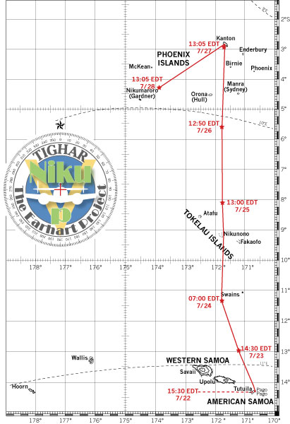
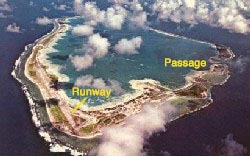 In
this photo of Kanton you can clearly see the still-serviceable 8,000
foot runway in the northwest corner of the atoll and the dredged
passage into the lagoon along the southwest side. The village and
wharf are along the lagoon shore to the left after you go through
passage. For a sense of scale, the lagoon is four and a half miles
across at its widest point. (Thanks to Peter McQuarrie and
In
this photo of Kanton you can clearly see the still-serviceable 8,000
foot runway in the northwest corner of the atoll and the dredged
passage into the lagoon along the southwest side. The village and
wharf are along the lagoon shore to the left after you go through
passage. For a sense of scale, the lagoon is four and a half miles
across at its widest point. (Thanks to Peter McQuarrie and 
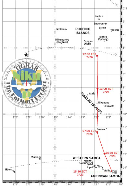
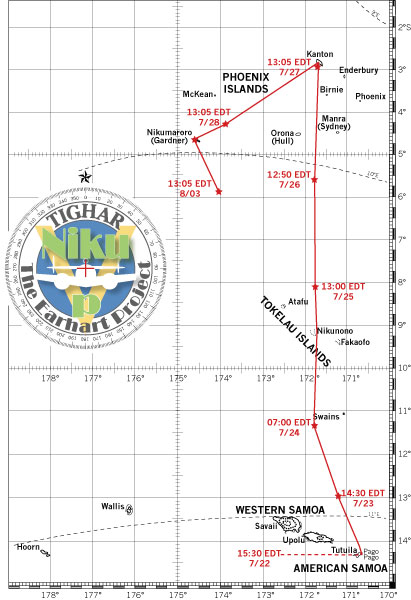
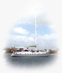 The
winds are set fair and, with the aid of Scopolamine patches, Van
tells us it’s a pleasure to be aboard Mollie and finally
moving. They cleared port in Pago at about 3:30 Tuesday and have
made good time so far. At an average speed of around 6 knots they
are estimating arrival at Kanton Island on Sunday afternoon.
The
winds are set fair and, with the aid of Scopolamine patches, Van
tells us it’s a pleasure to be aboard Mollie and finally
moving. They cleared port in Pago at about 3:30 Tuesday and have
made good time so far. At an average speed of around 6 knots they
are estimating arrival at Kanton Island on Sunday afternoon.