|


|
|||
|
|
|
|
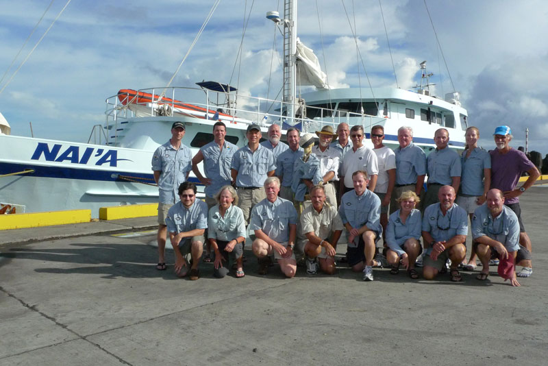
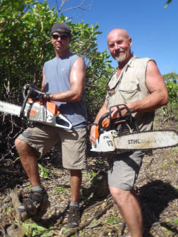
The Niku VI team. Back row: R/V Nai’a, Jesse Rodocker, Bill Carter, Leonid Sagalovsky, Tom Roberts, Walt Holm, Gerald, Tom King, Jon Overholt, Andrew McKenna, Gary Quigg, Art Carty, Graham Berwind, Megan Lickliter-Mundon, Mark Smith. Front row: Taylor Keen, Lonnie Schorer, Ric Gillespie, John Clauss, Dan Lann, Janis Carty, Karl Kern, Curtis Webster.
It was the largest, longest, most complex, and most expensive TIGHAR expedition ever, and the most successful. The Niku VI expedition returned to the U.S. with over a hundred artifacts; several hundred bird, fish and turtle bones; and reams of new data, observations and measurements; all of which must now be cataloged, analyzed and interpreted.
Digging for DNA
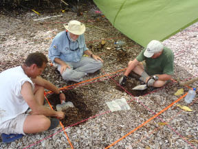
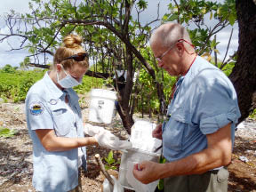
Under the direction of TIGHAR Senior Archaeologist Dr. Tom King, onshore archaeological work focused on the Seven Site, the remote spot on the island’s southeast end that best matches the description of where the partial skeleton of a castaway was found in 1940. Each time we return we find that the dense bush we worked so hard to clear has grown back and we have to start over.
Whether or not the expedition found conclusive evidence that the castaway was Amelia Earhart remains to be seen, but the TIGHAR team accomplished its goal of finding objects from which it might be possible to recover the castaway’s DNA. Among the many artifacts found were several which appear to have been handled by the castaway. These were collected using special sterile procedures designed to minimize the chance of contamination with the collector’s own DNA. Ten of those artifacts, judged to be the most likely to yield DNA, are now at a laboratory in Canada where scientists will attempt to extract mitochondrial DNA (mtDNA) for comparison to a reference sample of Earhart mtDNA provided by the Earhart family. Results are expected some time later this summer. Betting Against the House
A word of caution: Although retrieving contact or “touch” DNA from handled objects is routine in present-day criminal investigations, the survival of usable DNA on items that have been subject to a harsh tropical environment for many decades is problematic in the extreme. By taking special collection precautions in the field and using scientists who are highly skilled and experienced in extracting “ancient” DNA, we’ve stacked the cards in our favor as much as we can. Nonetheless, we must accept that the odds are against us. More Pieces of the Puzzle Regardless of how the DNA gamble plays out, other discoveries, once identified and analyzed, should give us a better picture of how the castaway(s?) survived and for how long. Most importantly, the more precisely we can identify the artifacts that appear to have been used by the castaway, the more clues we’ll have as to the castaway’s identity. Our historical research and archaeological work in 1996, 2001, and 2007 produced evidence that suggests three general types of activity at the Seven Site at different, and in some cases, probably overlapping times: Not earlier than 1933 and not later than 1939
Not earlier than 1940 and not later than 1963
Not earlier than 1944 and not later than 1946
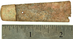
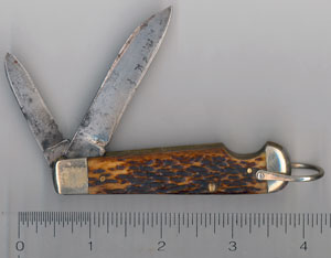
Preliminary interpretation of the results from this expedition’s work reinforces that characterization of the site’s history. In other words, we found more evidence of those same activities. In some cases, we found more of the same artifact. For example, in 2007 we found one small part of a pocket knife we were able to identify as an Easy-Open, bone handled, double bladed jackknife made by the Imperial Cutlery Company of Providence, RI between 1930 and 1945. This time we found the rest of the knife, except for the blades. It is now apparent that someone beat the knife apart with a blunt object, breaking it open for the express purpose of removing the blades. Why? To make spears for catching fish? We can only speculate, but at least we have a better understanding of what happened to the knife.
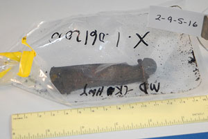
Like the glass pieces that match the mirror of a 1930s-vintage compact and the bits of cosmetic found in 2007, some of the “new” artifacts may prove to be specific to a female. We found more pieces of what appears to be the same cosmetic; a small glass jar (broken) that seems to have a distinctly feminine appearance; a broken bottle that had the “Mennen” trademark embossed on the side; and so on. Much more research is needed before we can say how or whether these pieces fit in the puzzle we’re trying to solve.
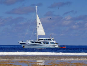
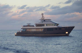
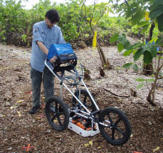
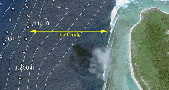
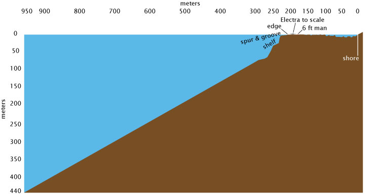
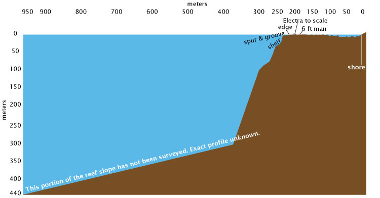
We also tried, for the first time, to use Ground Penetrating Radar (GPR) to look beneath the surface for buried objects or disturbed areas that might suggest a burial. We discovered, however, that the coral rubble of the Seven Site is laced with roots and pockets of air that produce a myriad of false targets for the GPR. More research is needed to determine if and how GPR can be an effective search tool in the difficult coral atoll environment. We’re grateful to TreeRadar, Inc. of Silver Spring , MD for the loan of the GPR and to Taylor Keen for coming along to operate it. Looking for the Plane The other major component of the NIKU VI expedition was the ability, for the first time, to explore the deep water off the western end of the island for possible aircraft wreckage. The only data anyone had about the underwater environment below scuba depth (about 100 feet) in that area were a few soundings taken during a U.S. Navy survey in 1939. The soundings indicated that the bottom was at 240 fathoms (1,440 feet) about half a mile out from the edge of the reef.
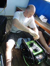
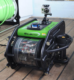
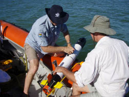
The hypothesis to be tested was that the plane had gone over the reef edge at a point about 400 meters north of the Norwich City shipwreck. The plan was for Jesse Rodocker of SeaBotix, Inc. to use the company’s LBV compact Remote Operated Vehicles (ROVs) equipped with high definition video to search the reef slope down to 300 meters (984 feet) which, we reasoned, should cover the area in which large, heavy pieces of wreckage might come to rest. Assisting Jesse were TIGHAR veterans John Clauss and Walt Holm. Setbacks and Surprises
The fiber-optic cable that carries the HD television signal through the ROV’s umbilical tether is delicate and Jesse’s long tether was damaged in transit to Samoa. Fortunately, our second ship was able to bring a replacement but for the first two weeks the team had to use a shorter back-up tether and could only search to a depth of 150 meters (492 feet). Neither of the two expedition ships was ideally suited to supporting the ROV work but Jesse, John and Walt succeeded in searching a large portion of the reef slope. The reef was surprisingly clean. Other than some wreckage from the SS Norwich City, the only man-made objects found were two lengths of small diameter rope at about 200 meters (660 feet). An object that at first seemed to be a circle of wire was later judged to be more likely of natural origin.
In addition to the ROV, we were fortunate to have an IVER2 Autonomous Underwater Vehicle (AUV) on loan to SeaBotix by OceanServer, Inc. The AUV, supplemented by a towed side-scan sonar, was used to map approximately 80% of the lagoon. The biggest surprise, and the biggest factor limiting our search, was the unexpected steepness of the reef face at Nikumaroro. Instead of a fairly even slope from the base of the previously explored area out to the first deep water sounding half a mile off shore, the slope plunges almost immediately to a depth of 300 meters (984 feet) before the bottom begins to level out enough to have reasonably caught aircraft wreckage. In other words, we discovered that the prime search area begins where our capability to search ended. To search for the plane we’ll need to be able to work down to 1,000 meters (3,280 feet). That’s still relatively shallow and well within the capabilities of available technology (the searches for the Electra in the area near Howland were conducted at depths five times greater) but to search where we need to search we’ll need a vessel with “dynamic positioning” – the ability to maintain a stationary position at sea within a tolerance of a few meters. That’s going to be expensive.
|
||||||||||||||||||||||||||
Our special thanks to the corporate and individual sponsors of The Earhart Project, without whom nothing would be possible:
The TIGHAR Board of Directors And the loyal membership of TIGHAR. |
|
||||||||||||