|

|
|||
|
|
|
|
|
Presented here is Dr. Tom King’s briefing to the expedition team members who will work under his supervision at the Seven Site during the upcoming expedition.
Here are some things that everyone planning to work at the Seven Site should be aware of. A lot of it’s pretty basic, but I thought it would be well to make sure we all understand one another. Archaeology is all about context – the spatial relationships among things. It’s from these relationships that we can reconstruct what happened in a given location, how a given thing came to be where it’s found, which things got deposited in the site before other things, and so on. In traditional archaeology we’re very much concerned about both horizontal and vertical relationships. At the Seven Site there’s not much to the vertical dimension; everything is pretty much in the top 10 cm. or so of the site. So in a way, what we do is a lot like crime scene investigation: where is the (smoking) gun lying vis-à-vis the broken flowerpot; that sort of thing.
There are vertical relationships to be recorded, too. For example, by carefully examining such relationships we were able to determine that a lot of small clams were deposited on one small part of the site, then a layer of asphalt siding was laid over them, and then some corrugated iron was laid on top of the siding. We don’t know what kind of time passed between these incidents, or why they occurred, but the fact that they were sequential might mean something, so it’s good we were able to detect it. Much of what we record on and recover from the Seven Site has no obvious relationship to Earhart, or even to the putative castaway who may have been Earhart. Such relationships may – or may not – emerge through later analysis, but no one should expect “aha!” moments in the field. We didn’t recognize the probable rouge in the field; we just recognized that it wasn’t coral or scaevola, and therefore it was unusual so we kept and recorded it. Similarly, we didn’t recognize the mirror fragments as mirror fragments in the field. In 2001 one of our team had a lot of trouble understanding why it was so important to collect all the fish and bird bones, and complained a lot about the time it took to do so. But on analysis, the kinds of fish represented (the bird bone analysis isn’t yet done) turned out to suggest that whoever was collecting and preparing the fish was not following standard Pacific island norms – and so was probably not an indigenous Pacific islander. That’s an important piece of data. It’s the slow accumulation of such data that gives us a basis for testing our hypothesis. So the bottom line is, we’ll be trying to record and map the locations of everything we find. Terminology and Standards There are some standard ways of doing archaeological fieldwork that we’ll be adhering to, and some that we’ll be modifying in various ways. And there’s some terminology we use that everyone ought to be familiar with. We use the metric system; measurements are in meters, centimeters, and occasionally millimeters. We do not impose a metric grid system over the whole site. That’s often done in archaeology, but it’s time-consuming, tedious, and generally a pain in the behind when you’re working a site like the Seven Site, on a convoluted ridge with lots of vegetation. When we elect to concentrate on a particular location, however, we do lay down a metric unit or units within which to work. This is usually a 1x1 meter or 2x2 meter square, or a 1x2 meter rectangle, or a combination of multiple such polygons. Each square or rectangle (called a unit) is given a designator (examples from 2007: “SL-3,” “WR-1”). Their locations are carefully mapped in, and we then map in things we find within a rectangle by measuring from two perpendicular sides. We generally dig in 10 cm. levels, though in point of fact we seldom find anything deeper than 10 cm. Everything from a given level in a given unit (and sometimes from a sub-unit – e.g. the NW quarter of Unit XB-7, 0-10 cm. level) is typically passed through a sieve or screen (we call them screens, the Brits call them sieves), and kept together in a labeled bag (or bags). It is critically important to label every bag accurately, and keep the label intact (don’t let it get rubbed off). Surface finds are also “tagged and bagged.” Our screens are PVC rocker screens lined with ¼″ mesh hardware cloth. We have 1/8″ gauge inserts that we seldom use, but have on hand just in case.Saying the material from a level is “passed through” the screen is a bit of a misnomer, since the site is mostly coral rubble that just sits in the screen and glares at us. We go through it by hand, throw out the rubble, pick out the artifacts, and the little bit of humus that exists falls through. We keep all “artifacts” – that is, things made by people, and many “ecofacts” – that is, things created by nature. Of course, we don’t keep every chunk of Scaevola bark, or every lump of coral or marine shell, but we do keep all bones, turtle shells, etc. We record all “features” – that is, concentrations of things that may represent human activity. Some examples of features we’ve recorded are: “Clambushes.” Clambush is a term we made up for clusters of Tridacna (“giant”) clam valves, clearly the remains of someone’s clambake. We’ve found two, creatively labeled Clambushes 1 and 2. “Shell scatters.” We’ve found only one of these so far; it’s a scatter of small “butter clam” (Anadara sp.) valves, also probably the remains of a meal. “Birdbone scatters.” As the term implies, these are scatters of bird bones. “Corrugated iron features.” Sheets of corrugated iron, reduced to rust on the ground. We also record the locations and characters of such natural features as living trees, dead trees, pits, swales, irregularities in the ground surface, etc. We systematically scan the surface of the site with metal detectors, as well as visually. In 2007 we also scanned about half the surface of the site using the Clauss/King Unpatented Daylight Ultraviolet Scanner (UDUS). Bones and teeth fluoresce in UV light. It worked, but didn’t reveal any human bones or teeth, and is very tedious to use. It was necessary to rake the surface in advance of UDUS scanning. What I’ve just described is our standard way of doing business at the Seven Site. We propose this year to do things a little bit differently, as described below. Research Plan We have four goals at the Seven Site in 2010:
The site presents some serious physical challenges, notably:
In the past we’ve cleared the Scaevola off areas of the site (dragging it to clearings where it could be piled, or just throwing it deeper into the bush), done systematic metal detecting, ultraviolet light scans, and raking, and excavated selected locations (mostly fire features) employing standard archaeological methods. I think we now understand the site well enough to take a somewhat different approach. This approach will be destructive: I propose to turn over essentially the entire surface of the site. This is an inherent problem in archaeology: we destroy what we study. Proposed Fieldwork
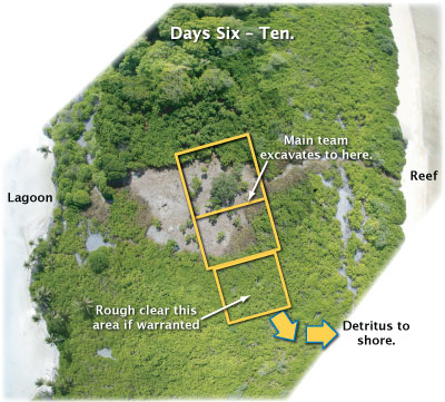
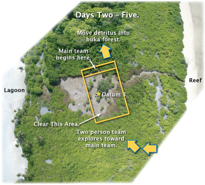
As soon as the cutters have cleared an area of about 10x30 meters, I propose to peel two people off to cut in from the ocean side to a location 30 to 50 meters SE of the 2007 cleared area. Having reached the ridge (along a path of least resistance plotted in satellite imagery), this team will clear a good broad swath back to the 2007 clearing, enabling us to make sure that the site’s features don’t extend any farther along the ridge than we’ve mapped. By about Day Three on the site, while the exploratory cutting team is cutting SE of the cleared area, we should be able to get to work on actually “excavating” the site. I figure that we’ll stake out a line perpendicular to the ridgeline and running right across it, near the NW end of the clearing. Along this line I figure we can deploy about 7 team members, each responsible for about 5 meters of the line. We’ll also need to set up the total station surveying instrument over Datum 3, the most convenient of our datum points to use in mapping along the ridge. We’ll hold 2 or 3 screens (sieves) in readiness. One team member will serve as Evidence Manager (EM), making sure that anything that might have DNA on or in it is collected with sterile gloves, and that all bags are correctly labeled with provenience data. | ||||||
 Each person along the line will then begin simply scraping the surface with
a trowel, moving the top 5 cm. or so of coral rubble back behind him or her
to expose and examine the surface. He or she will go on and do the same thing
to the 5 cm. or so of finer-grained material underlying the surface armor.
Every time an artifact, feature, bone, or anything else other than coral and
Scaevola detritus is encountered, it will be shot in by the total station crew,
labeled and bagged, always using latex gloves to avoid DNA contamination. An
exception will be made for ferrous metal, which is ubiquitous on the surface;
it will be mapped and sampled, but not collected in its entirety. Each person along the line will then begin simply scraping the surface with
a trowel, moving the top 5 cm. or so of coral rubble back behind him or her
to expose and examine the surface. He or she will go on and do the same thing
to the 5 cm. or so of finer-grained material underlying the surface armor.
Every time an artifact, feature, bone, or anything else other than coral and
Scaevola detritus is encountered, it will be shot in by the total station crew,
labeled and bagged, always using latex gloves to avoid DNA contamination. An
exception will be made for ferrous metal, which is ubiquitous on the surface;
it will be mapped and sampled, but not collected in its entirety.
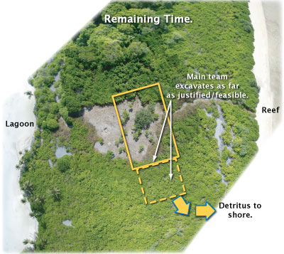
As the clearing is completed, clearing crew members can trade off with surface scrapers, or give special attention to particular locations, or open up areas that the exploratory team has found (if any). Assuming the site is not much more extensive than what we mapped in 2007, I estimate that by the end of 14 days we will have turned over the entire surface of the ridge, finding and recording whatever is there to be found. Besides field notes and total station mapping, we will document the site using Kite Aerial Photography and Pole Aerial Photography. We will use the daylight ultraviolet scanner on any areas where there is reason to think that bones might be lurking. | ||||||
|
||||||
Ancillary Research at Ritiati/Karaka Village Study of fishbones from the Seven Site by Dr. Sharyn Jones of the University of Alabama at Birmingham has suggested that the patterns of fish procurement and consumption are unlike those found in indigenous cooking sites – in other words, that whoever cooked the fish was probably not a Pacific Islander. It would help us evaluate the typicality of the fish remains at the Seven Site if we had something from Nikumaroro itself with which to compare them – that is, if we had the cookfire of a demonstrably local population. Although we do not have a “campfire” produced by such a population on Nikumaroro, we do have domestic cookhouses in the colonial village of Karaka, on the land unit called Ritiati in the north-central part of the island. I propose to excavate one or two cookhouses in Karaka Village to gain material to compare with the fire features at the Seven Site. Bottom Line The main thing I want to impress on everyone is that everything we do and observe must be carefully recorded, and that as with so many other things in life, what’s important is location, location, location. We are unlikely to experience great and obvious “ah-ha!” discoveries in the field; we’re most likely to learn things from the post-fieldwork analysis of things and relationships between things. And learning from such things and relationships requires that they be fully and carefully recorded in the field. |
|
||||||||||||
 Introduction: Some Basic Archaeology
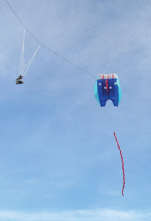 This is why we’re so careful about mapping, and plotting in the location of
each item found. We do this with varying degrees of anal-retentiveness, but
generally we want to record carefully where each thing is before we move it.
We’ve established a central “datum point” over which we set up a total station,
and we map everything in with reference to that point. We’ll supplement the
mapping with overhead Kite Aerial Photography and Pole Aerial Photography (KAP & PAP).
This is why we’re so careful about mapping, and plotting in the location of
each item found. We do this with varying degrees of anal-retentiveness, but
generally we want to record carefully where each thing is before we move it.
We’ve established a central “datum point” over which we set up a total station,
and we map everything in with reference to that point. We’ll supplement the
mapping with overhead Kite Aerial Photography and Pole Aerial Photography (KAP & PAP).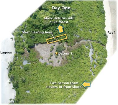 As soon as we arrive on the island and get a boat into the lagoon, I propose
to move a team to the Seven Site to begin clearing Scaevola at the NE corner
of the area we cleared in 2007 (which will certainly have grown up again, but
appears from recent satellite imagery to have grown up rather lightly). It
should take us about two days to clear the 2007 area. We’ll carry the cuttings
back into the Buka forest NW of the clearing and pile it there (first carefully
checking the debris-pile site to make sure we’re not covering something up).
We won’t necessarily stick to the limits of the area cleared in 2007; the basic
idea is to clear an area about 30 meters wide running along the crest of the
ridge that bisects the site. Needed technology will include pneumatic loppers,
chain saws or other brush cutters, knives, and trimmers.
As soon as we arrive on the island and get a boat into the lagoon, I propose
to move a team to the Seven Site to begin clearing Scaevola at the NE corner
of the area we cleared in 2007 (which will certainly have grown up again, but
appears from recent satellite imagery to have grown up rather lightly). It
should take us about two days to clear the 2007 area. We’ll carry the cuttings
back into the Buka forest NW of the clearing and pile it there (first carefully
checking the debris-pile site to make sure we’re not covering something up).
We won’t necessarily stick to the limits of the area cleared in 2007; the basic
idea is to clear an area about 30 meters wide running along the crest of the
ridge that bisects the site. Needed technology will include pneumatic loppers,
chain saws or other brush cutters, knives, and trimmers.