On June 8, 2015, TIGHAR’s Niku VIII expedition sailed from Fiji to conduct three types of search operations at Nikumaroro, Republic of Kiribati: ROV investigation of the anomaly seen in 2012: scuba search for any small items just off the Bevington Object location; and a land search for the initial campsite just in shore of the Bevington Object location.
Daily Reports, Week 2
To avoid
lengthy download times, the updates are divided into seven
day periods. This is the first week of the expedition. Date links refer
to U.S. days; the ship will keep U.S. dating so that there is slightly less confusion.
Reports
are in reverse date order so that those who check every day don’t have to
scroll down endlessly as the expedition progresses. If
you are new to this page, just click on the earliest date to the right (down
at the bottom of the list) and then scroll up to read each posting in order. For previous weeks, click on the “Week” links above.
Funding for this expedition is still a little short due to changes in travel and shipping. Your support is critical at this stage. To make a donation to the Earhart Project, click HERE.
Yesterday the channel was too rough for the Land Team to go ashore. Everyone stayed put and rested, and worked on notes and photos.
Today, if the skiff can get into the channel, Mark and Lonnie will do what they had originally planned for today: walk down the south shore with the small drone, taking video of various points, and fetching up at the Seven Site to see what may be seen there. The rest of the land team will go back to Nutiran and work along the vegetation line as planned.
Dive Team
The Dive Team finished up their planned lines, and then began experimenting with Rob's underwater camera to find out if it could be stabilized sufficiently to get decent photos/video of the shelf at 200 feet. Answer: Yes, it can. They will continue to work on that today. We would like to avoid a highly technical dive if the work can be done by machines.
ROV Team
Walt Holm brought along his small home-built ROV, and it was tested yesterday. It appears to be a good vehicle for additional work at the 200 foot level. While it cannot go to the anomaly (600 feet is too deep for it), it can certainly join the search for the debris field Jeff spotted.
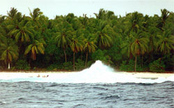
This shot of a wave exploding in the channel was taken in 1997. The plume is approximately 30 feet high. This is not a good place for a small boat with a lot of people in it. TIGHAR photo by P. Thrasher.
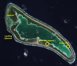
Satellite photo of Niku with the Seven Site and Aukairame Shoe Site marked.
Dateline: 20 June 2015, 13:00 EDT, Nikumaroro
Land Team
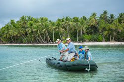
Ric and Laurie went in a skiff, with a Nai’a crew member, to attempt to re-create the Bevington photo. They couldn’t get it exactly, largely because Laurie’s camera and lens are so different from Eric Bevington’s, but the geometry was reproducible.
Gary, Lonnie, and Rodney went ashore to re-locate important sites in the Village and to look for aluminum. With all the evidence of washover and storms, it would be a shame to not at least look around.
The next step was to go out on the reef flat to look for points indicated by the Synthetic Aperture Radar scan. The points were found; nothing there but Norwich City wreckage.
Back to the village, and the skiff came to collect them. It was more exciting than optimum; a large high pressure area down near Fiji has set swells up to 12 feet high running directly into the channel. But all was well in the end.
Today the skiff won’t go in if the sea situation is the same, it’s too risky. If things are calmer, the Land Team will work on Nutiran, along the boundary between the beach and the vegetation. While it’s not too likely anything has survived and is visible or detectable in that area, it is by far the most likely area for a Camp Zero. They will also try to relocate the “European House” from the Arundel plantation days, back in the 1890s.
Meanwhile, Mark and Lonnie will hike down the south shore to the Seven Site and get some drone footage of the area. It is grown in fully, of course, but still should be interesting.
Dive Team
The divers continued searching their lines and found nothing man-made. They will probably finish their grid today.
The plan for divers to go deeper and look for the debris field Jeff Glickman spotted is coming together. It’s at about 200′; looking over the edge of the ledge they are working on they can’t see it, but have been able to place some buoys for the ROV. They have good lat/long information and should be able to navigate to the site with high confidence. Our two most experienced divers, Jim Linder and Capt. John of Nai’a, will do the dive if necessary. It will be a technical mixed gas dive and not something to undertake lightly.
ROV Team
The ROV is still not functioning correctly. Current hypothesis is that there is some sort of internal flaw in the system that has caused this unfortunate cascade of problems. Ron is on the phone to a Seabotix technician constantly and there is still hope that things will resolve.
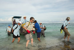
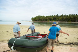
All ashore that’s goin’ ashore! Disembarking from the skiff at the landing channel. TIGHAR photo by Laurie Rubin.
A homing pigeon ... errr drone ... flies to Mark’s hands. TIGHAR photo by Laurie Rubin.
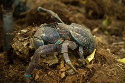
A coconut crab. About eight inches across the back. TIGHAR photo by Laurie Rubin.
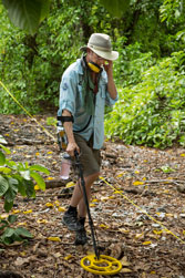
Andrew Sanger working the metal detection line. TIGHAR photo by Laurie Rubin.
Dateline: 19 June 2015, 13:00 EDT, Nikumaroro
Land Team
Yesterday was very productive. The ionosphere has settled down some, and they were able to get the handheld GPS units synched and working correctly. With the help of Lee and Andrew McKenna (the Dive Team did not dive), they worked on finding Jeff Glickman’s points of interest on land. All the GPS units agreed, and were further checked by compass and distance. This gives a high degree of certainty that the targets were found. After arriving at a given point, they did a thorough search of each area. As far as the Nutiran land area is concerned, there is no sign of anything whatsoever at those points. Either there never was anything there, or there was and the overwash activity has swept it away or hidden it at depths that are not susceptible to discovery.
The Camp Zero hypothesis has been thoroughly tested, with the result of “not findable.” Logically it makes all the sense in the world for it to have been there, but at this remove in time and storm activity, it’s gone.
Meanwhile, Jim Linder and Bill Rodgers hiked down to the far side of Baureke Passage and scouted around some for the door. This area will be covered again, if possible, by the group aboard the Fiji Princess, under the direction of Tom King.
Today a partial land team will do a search of the reef flat around the points out there Jeff identified, roughly from the Norwich City to the Bevington Object point. Having done that, they will head back across Tatiman Passage to the village, both the old and the new, to see if the recent overwash event(s) uncovered or cast up anything interesting.
Dive Team
As mentioned above, the divers did no underwater search work yesterday. Rob Barrel, owner of Nai’a, and Steve Genkins, a sponsor team member, dove off the the northwest tip of the island to check on coral bleaching and fish habitat health for NOAA, by special request. The reef around Nutiran is bleached and pretty barren, but the northwest side is much better. This is a function of the current El Niño event coupled with global warming of tropical waters associated with climate change. We were happy to help NOAA out with their record keeping, as it’s so seldom anyone can get as far as the Phoenix Islands to establish data points.
ROV Team
More adventures... Changing over to the HD camera involves terminating the cable, a complex and delicate job. The slightest error and you have to start over. Meanwhile, they discovered a power problem while testing at depth. There is a current as you go deeper at Niku, and the thrusters were not able to make any headway against it. So they worked on that as well, with the expectation that all would be fixed and ready for service this morning.
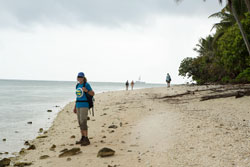
The long walk up the beach. Lonnie Schorer and the rest of the land team. TIGHAR photo by Laurie Rubin.
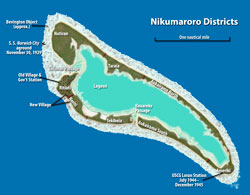
Map of Nikumaroro, with districts labeled.
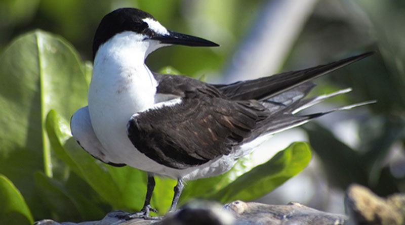
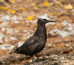
Juveline sooty tern, very interested in this procession of people and stuff. TIGHAR photo by Laurie Rubin.
Dateline: 18 June 2015, 13:00 EDT, Nikumaroro
Land Team
The Land Team actually found three man-made objects yesterday. Two are of no interest in terms of our search goals; the other is a weak possibility.
The first is an old wash-basin type metal container, perhaps 3-4 gallon capacity, looks like late 19th century. It’s galvanized, and has handles. Just sitting there. Nearby was a green plastic disposable cigarette lighter.
The third is a length of heavy wire or perhaps a thin rod. It’s a little more than a foot long. About the diameter of a fat pencil at one end, it tapers evenly to the other end. It was buried about 5cm down and was found with a metal detector. It isn’t stainless steel; it’s rusted and has roots attached to it the way metal gets in that soil. We don’t know if it’s high- or low-tech. The plan is to recover it and see what we can find out about it. Not very exciting, but curious.
Dive Team
More searching, no man-made objects. They are doing a very thorough job, with physical boundaries marking lanes, from the surface down to 130′. An underwater search like this has not been done before, with the expectation that the search area could be defined, drawn on a map, searched, and crossed off.
ROV Team
There are still problems but the issue of the optics on the camera has been resolved. The navigation system was working, but it was reading out flipped. That was a software problem that had to be debugged; it’s now fixed. By the end of the day, everything was working pretty well and they did a test dive to 150 meters. Only the standard definition camera is working right now but the HD camera will be up and running tomorrow. The scaling laser is on the HD camera so that’s a must.
They also need to test the nav system to 200 meters. It is rated to 150m, but will still work as they go deeper; they just need to find out how much slack gets into the figures at the greater depths. By tomorrow they should have 100% operational capacity. Which is a good thing, because in a couple of days the wind is predicted to drop off and the boat will not be able to hold station nearly as well.
Today’s Plan
The Dive Team is taking the day off. Most of them will join the Land Team in building blocks and searching them. There has been another geomagnetic storm and the GPS units are all fairly useless until the ionosphere settles down again.
They will be working in WE 7&8, and WF 7&8, looking into the targets Jeff and Jim provided. While GPS would be ideal for finding these places, the old fashioned method does work, and there is always the chance for a fortuitous find. That’s one of the Rules, of course: all important finds are made on the edge of the search area, where you almost didn’t bother to go.
Meanwhile, Jim and Bill will walk down to Baureke Passage and scout around for the door that was reported as a children’s plaything by people who grew up on Niku, then rejoin the Land Team in the afternoon.
The ROV crew will get the machine in the water and do whatever they can.
Nikumaroro is being hammered more and more frequently by more and more severe storms as global warming progresses. There isn’t much to find, no matter what you’re looking for, and things that have been kicking around on the island for 78 years are not much in evidence. We can’t control what’s left there to find, we can only control the diligence with which we do the work.
"Expeditions consist of carrying heavy awkward objects over difficult terrain in bad weather." TIGHAR photo by Laurie Rubin.
Ferrying a load over. From left: Ric Gillespie, Gary Quigg, Mark Smith (just his left arm), Lonnie Schorer, Andrew Sanger. TIGHAR photo by Laurie Rubin.
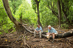
Executives in the conference room. Gary Quigg and Ric Gillespie. TIGHAR photo by Laurie Rubin.
Click on the photos to open larger versions on a new page.
Dateline: 17 June 2015, 13:00 EDT, Nikumaroro
Land Team
Yesterday the Land Team was in the New Village to re-locate known, marked graves. They only found one, of dozens known. Some may have been covered, or insufficiently recorded; but the one they did find tells a different story.
It was a unique-looking grave, outlined with bottles neck down in the coral rubble, rather than the usual coral slabs. It was well inside the village the last time it was seen. Now it is on the beach, in front of the vegetation line, with the bottles half-exposed.
This prompted a discussion concerning tides and water on the reef. The sea level is rising, and that makes over-wash far more common. But what was the sea level in 1937? Does that affect the measurements we took? Certainly the reef is the same, but the water cover could differ by some significant amount.
The question of GPS reliability was also raised. Walt Holm, who is an expert in the field, gave a seminar in the evening on GPS, what it is, how it works, and how to use it. Today the first order of business for the land team is to meet on the bridge of Nai’a with all available hand-held GPS units, and calibrate them to Nai’a’s very accurate GPS. From there the team will begin to check out the points of interest from Jeff and from the SAR provided by Jim Linder.
Dive Team
The Dive Team continued with the patterns they have been using. They found a piece of line with some hardware on it, which they brought up. It is long-lining equipment; in fact, Suli (the chef) has an identical piece of hardware she uses as a key chain. While off-gassing they swam ashore and did some wandering around, but it’s not much fun in a wet suit, without heavy boots.
Because they are working deep (140′), they can only dive for 30 minutes at a time, and must recover for a correspondingly greater time. The schedule allows for only two dives a day. The area they are exploring is accessible, but has never been looked at closely before. It’s not efficient, but there’s no good way around it.
Tomorrow the Dive Team stands down and will assist the Land Team.
ROV Team
The ROV is still not operational. It should be by this afternoon. Ron has offered to jump overboard holding a cannon ball and go look at the anomaly himself. We have refused this offer, prefering to bring everyone home alive and well. It’s the story of high technology at Niku; it’s a terrible environment, even for machinery that is designed to operate there.
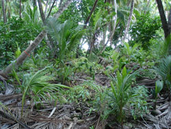
A view of typical village jungle from Niku V. TIGHAR photo by Tom Roberts.
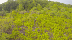
This is a shot from the drone. The land team is in there. Really. Click on the image to open a larger version... TIGHAR photo by Mark Smith.
Dateline: 16 June 2015, 13:00 EDT, Nikumaroro.
Land Team
Yesterday the land team re-searched the box searched the day before. They changed direction from East to West and ran their lines North-South. This was largely a test to be sure they were not missing anything, and in fact they are not. The same little bits of blue cellophane, and one small orange bottle cap were the haul. The current hypothesis is that the birds bring things like that in as possible nesting material; boobies especially pick up all kinds of stuff. The area has been overwashed; there are coconuts scattered around, but no coconut trees, and the only way for the nuts to get there is by water, there being no African swallows about (they are non-migratory, you know).
From WF-5 they went up to WG-5 where there is a pretty good-sized pond in the NW corner. It is salt, and shallow – not a source for drinking water.
From the two days’ experience in the area, they are coming to the conclusion that this buka forest is not a very likely place for Camp Zero. It’s one thing to sit in an air-conditioned office and look at maps and remember the Seven Site buka – but that stand is to windward, and it is cathedral-like and very pleasant. This stand is to leeward. No breeze. Very hot, very still, very humid. There are bird droppings everywhere, and it stinks. It’s a difficult five to seven minute walk from the beach; you can’t see the beach or the reef from the forest, and you could not, therefore, keep an eye on your airplane, which is your life-line, nor on the horizon from which you expect rescue.
It seems more likely they would have chosen a place down by the beach, under one of the many ren (Tournefortia argentea) trees which provide great shade. BUT – if that’s where they were, anything they left is long gone or buried under tons of coral rubble.
Well, no plan survives contact with the enemy. Hypotheses are tested, revised, new tests devised, and revised again in the light of new information.
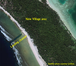
Today a group will go to the new village area (see photo at right) to do an errand for Tom King and Dawn Johnson, who will be arriving on the Fiji Princess later in the expedition. We have been considering cadaver dogs for years, but with no certainty as to the likelihood of success with them we have hesitated to subject the dogs to the harsh environment, nor to the confinement of the boat. So we are going to collect surface soil samples in the new village, from the surface of known graves (which are clearly marked) and from random other surface areas. We’ll take the samples back and see if the dogs can differentiate them. Much easier to take the dirt to the dogs than the dogs to the dirt!
Then we will begin locating and examining the points of interest suggested by Jeff Glickman, now that the GPS system seems to have settled down following a major geomagnetic storm.
Dive Team
Yesterday the dive team found some Norwich City debris north of the shipwreck. This was quite surprising as the current goes the other way, and may cause us to revise some others of our hypotheses. They will keep working along their lines and see what is to be seen. Some time today a map will be generated using the GPS system aboard Nai’a which can be matched with the grid map; I hope to have this to post tomorrow to show their progress.
ROV Team
The ROV is fixed and has been tested successfully. It goes in the water for real today. It turned out to be a bad thruster, which was replaced. A great team effort by Ron, Walt, and John.
In General
Nai’a had to leave moorings last night as the wind died off and was no longer keeping them off the reef. It’s not a big deal, just means steaming off and drifting until dawn, coming back in, and picking up the moorings again.
Just for fun:
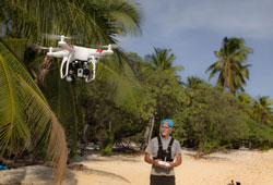
Mark test flies the drone on the beach. TIGHAR photo by Laurie Rubin.
As always, click on the photos to open large versions in new windows.
Dateline: 15 June 2015, 13:00 EDT, Nikumaroro.
Land Team
The first full search box was built and searched. It’s a box 50m x 50m, beginning at Datum 1, WF-5.
Boxes are laid out in a fairly low-tech way. One person goes out front with a bush knife and compass, and carefully cuts a pathway through the undergrowth on a heading. A second person comes right behind with a measuring reel, while a third person holds the end of the tape consistently on the start point. A fourth person follows on, rolling out the bright yellow surveyor’s tape to make a physical box. Get to the 50 meter mark, turn at right angles, and repeat. For convenience’ sake they are using due N, S, E, W, as there are no particular terrain features to get in the way.
Once the box is laid out, the team forms up on line, about five meters apart, and works slowly along, looking at the ground. Their eyes are still getting adjusted to this sort of work. The trick is looking at what is there, seeing it, asking “Why is it like that?” Don’t look “for,” look “at.” Metal detectors provide some ground penetration.
The box contained one man-made thing that they saw, a piece of light blue transparent cellophane, about 2 cm on a side, that may have blown in on the storm. Nothing else.
It’s buka forest, home to a large colony of sooty terns. They were very offended by the drone, but couldn’t quite figure out how to attack it with all those whirly things on the top.
The Land Team traditionally survives on salty chips, cookies, and water. Lunches are brought ashore, but often everyone is too tired to eat anything ambitious.
Today they will hike in/ferry in as usual, but some of the boat crew will bring a re-supply of snacks and water at late morning. That will enable the team to move much faster as they go ashore, and save a good deal of time.
Sooty Tern on Howland Island. US Fish & Wildlife.
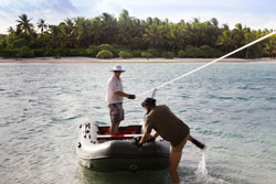
The rope ferry. TIGHAR photo by Laurie Rubin.
Click on the photos to open larger versions on a new page.
Dive Team
The baseline for searching is laid, and routine search work began yesterday. A piece of coral that looked something like a landing gear fork caused some excitement, but turned out to be ... well, coral. Otherwise, things are pretty bare.
Today they expect to make three dives, going to 140 feet.
Click on the photo to open a larger version on a new page.
ROV Team
The ROV has a problem which is currently preventing operations. All systems shut down on immersion in water. They are on the line to Seabotix to figure out what is going on. Pretty normal for high technology at Nikumaroro...
Click on the photo to open a larger version on a new page.
Radio
Lee Paynter has rigged another antenna ashore, which may allow broadcasting on more frequencies. If you are listening:
Call Sign
T31LP
Frequencies to listen on
14.280 MHz
14.310 MHz
Time
0400GMT
Local time
GMT + 12
and hear anything on shortwave, please post to TIGHAR’s Facebook page with your time, frequency, and location.
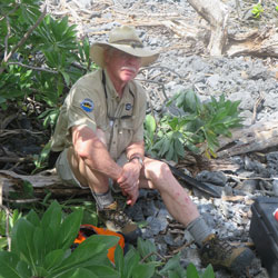
Ric in the coral rubble. TIGHAR photo by Lonnie Schorer.
Click on the photo to open a larger version on a new page.
Our special thanks to the corporate
and individual sponsors of The Earhart Project, without whom nothing would
be possible:
The
Earhart Project is funded by charitable contributions. Donations by check
(payable to TIGHAR) or credit card (Visa, Discover, American Express or Master Card) may be sent to TIGHAR,
The Earhart Project, 2366 Hickory Hill Road, Oxford, PA 19363, USA, or click on
the link above to make your contribution. Confidential inquiries regarding
sponsorship opportunities for individuals or corporations should be addressed
to Executive Director Richard Gillespie (email Ric@tighar.org).
Copyright 2021 by TIGHAR, a non-profit foundation.
No portion of the TIGHAR Website may be reproduced by xerographic,
photographic, digital or any other means for any purpose. No portion
of the TIGHAR Website may be stored in a retrieval system, copied,
transmitted or transferred in any form or by any means, whether electronic,
mechanical, digital, photographic, magnetic or otherwise, for any purpose
without the express, written permission of TIGHAR. All rights reserved.