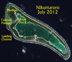
On June 8, 2015, TIGHAR’s Niku VIII expedition sailed from Fiji to conduct three types of search operations at Nikumaroro, Republic of Kiribati: ROV investigation of the anomaly seen in 2012: scuba search for any small items just off the Bevington Object location; and a land search for the initial campsite just in shore of the Bevington Object location.
Daily Reports
To avoid
lengthy download times, the updates are divided into seven
day periods. This is the first week of the expedition. Date links refer
to U.S. days; the ship will keep U.S. dating so that there is slightly less confusion.
Reports
are in reverse date order so that those who check every day don’t have to
scroll down endlessly as the expedition progresses. If
you are new to this page, just click on the earliest date to the right (down
at the bottom of the list) and then scroll up to read each posting in order. For previous weeks, click on the “Week” links above.
Funding for this expedition is still a little short due to changes in travel and shipping. Your support is critical at this stage. To make a donation to the Earhart Project, click HERE.
With this post we begin referring to the Grid Map.
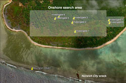
Land Team
The first full day of work brought the usual frustrations, surprises, and hard labor, at least for the land team. The rope ferry does work (WI14) but it’s not a row on the pond. There is no way to make it two way – once it has crossed over, it has to be brought back if someone else wants it.
The team moved all the gear – water, food, metal detectors, tape reels, everything – in the morning. They established their initial base just inshore of a landmark known as the “south tree” (WD7). The first thing they discovered is that the South Tree is tipped over and uprooted. Further investigation showed that there was a major storm at Nikumaroro sometime after the image on Google Earth was taken; there are new storm ridges, the flotsam is all cleaned off, and there is damage everywhere.
The rest of the day’s mission was to start checking out the points of interest from the 1938 photo and the SAR image. But nothing is simple or straightforward on Nikumaroro. The area is clogged with dense te mau (scaevola frutescens), which forms a network of dried, tangled branches and roots with the durability and resistance to cutting of iron. Getting through it means climbing and clambering about, while attempting to navigate.
Which is when they discovered that the map and the GPS disagreed, sometimes by hundreds of feet. Fallback was compass (azimuth) and measuring reel. It works, but it’s time-consuming. They looked at the place Jeff Glickman identified as a possibility for debris, but with the storm(s) anything that might have been there is gone.
Mark flew the drone, and it is a great tool for advance reconaissance in dense brush. We hope to have some photos to post tomorrow.
They returned to Nai’a to regroup, where they learned that the GPS problems were not user error; apparently the satellite was having a bad hair day and sending out erroneous readings. They will be prepared to use either GPS or compass and tape tomorrow.
Click on the photo to open a larger version on a new page.
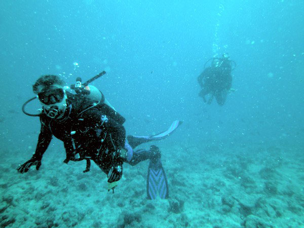
Dive Team
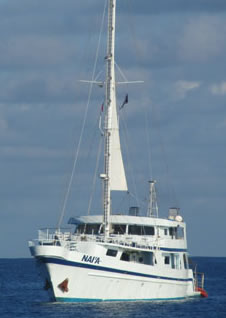
The dive team’s first order of business was to place the ROV transducer on the keel of Nai’a. That done, they proceeded to general orientation and the placing of a baseline. Since Nai’a is moored off to the wreck of the Norwich City, quite close to the reef, they also placed strobes just off the reef so that it is visible at night. One does not wish to be the second shipwreck on the reef.
Down to about 80 feet there are lots of fish, but the coral looks unhealthy, even dead. There aren’t nooks and crannies and mini-ledges to hold debris. From 80 to 140 feet or so, the reef looks healthy, with lots of places for bits of airplane wreckage to hang up. They will concentrate their efforts on this area, but because it is deeper than originally planned, they’ll require more off-gassing time.
Click on the photo to open a larger version on a new page.
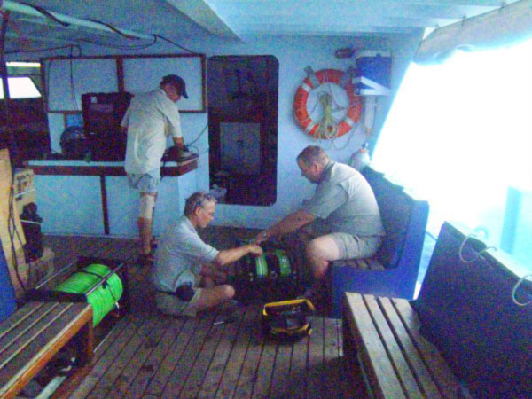
ROV Team
Ron, Walt, and John worked all day on getting the ROV set up with the high definition camera and the laser scaler. It’s finicky work, and the only way to get it right is to make haste slowly.
Click on the photo to open a larger version on a new page.
Today
The land team will go to the other end of the planned search area, at about WD5/WE5, go inland about 110 meters, and establish Datum 1 at the southeast corner of WE5. There is buka (pisonia grandis) forest there, and a clearing of sorts. The plan is to build search boxes from there to the south. At least one box will be built and searched today. There seems to be little point in bashing around in the scaevola looking for small items that have been washed out to sea by the recent storms.
The ROV will go in the water for test dives today. Greater depths will depend on how well the test dives work out, and if anything needs to be fixed.
The dive team will begin formal search operations.
Click on the photo to open a larger version on a new page.
Dateline: 13 June 2015, 13:30 EDT, Nikumaroro.
Nai’a arrived at Nikumaroro at about 14:00 local time. The priorities were set: the moorings and the rope ferry. They are the two essential things from which all else will follow.
Nai’a is on a bridle to the wreckage of the Norwich City; a second line to a rock mooring will be set by divers this morning. The divers will also attached the transducer for the ROV to a bracket already attached to Nai’a’s keel, which will allow accurate tracking and mapping.
The first land team discovery was that the inflatable boat to be used for the ferry was bad out of the box. Not shipping damage – the valve to one inflatable cell was crushed in spite of being deep inside the folds of the packaging. A work-around was devised. The cell was inflated, then the valve was sealed with expanding foam. It’s pretty permanent; to deflate the cell at the end of the expedition they’ll have to puncture the skin. But the rope ferry is rigged and works, which is the most important thing.
Meanwhile, Ron Bernier and Walt Holm worked on readying the ROV for deployment. It will go in the water tomorrow.
Today’s plans for the land team call for Ric, Gary, Rodney, Lonnie, and Andrew Sanger to begin work on Nutiran, checking out features from the 1938 aerial photograph and the Synthetic Aperture Radar images. Good GPS fixes have been obtained from the images and can be used to navigate. The first target of interest is the area at the end of a long streak clearly visible in the 1938 image – possibly an impact scar? – to see what might still be there, if anything.
Seas are much diminished, and all hands are up and functional.
Radio note: There was no radio work last night as there was a glitch in the antenna. Lee expects to try today at 0400 GMT.
Click on the photo to open a larger version on a new page.
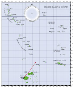
Dateline: 12 June 2015, 13:15 EDT. 5°10′S, 175°21′W
About 59NM out, so they will arrive at the island at about 13:00 local time. This has been a very rough passage, and they are down to about 8 knots. Even some of the crew is sick, and that’s pretty unusual. But nobody is whining, nobody has fallen and gotten hurt, and no equipment has been broken, so we’re still ahead.
Ric says the mood on board is rather like the line-up at a Formula One race, everyone revved up and full of plans and excitement and determination ... and the starter can’t find the green flag.
The team meeting last night brought on a discussion of Jeff Glickman’s new analysis of the 1938 aerial photo of Nutiran. Jeff sees not only a ground scar, but says with the right imaging techniques he is seeing traces of something – make that some Things – still there in the underbrush. It’s certainly something to look at very closely.
Further on the radio simulations:
Call Sign
T31LP
Frequencies to listen on
14.280 MHz
14.310 MHz
Time
0400GMT
Local time
GMT + 12
Be advised that the on-board radio antenna is not a good simulation of Earhart’s vee antenna. Once ashore, Lee will rig a much more accurate simulation and transmit from there.
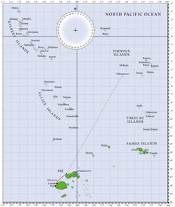
Route map: click on the map to open a larger version on a new page.
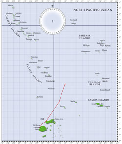
Dateline: 11 June 2015, 14:00 EDT. 7°56′S, 176°48′W
Now 237 NM out from Nikumaroro. They still expect to make landfall around sunup tomorrow local time. Low tide will be about 10:00 local time, and high tide about 15:00. They will set the moorings, get the inflatable boat overside, and go on a brief tour of the village and shoreline before walking the boat in on the rising tide and rigging the rope ferry.
The seas are still to high to get anything much done aboard. It’s one hand for the boat, one hand for yourself, and great care taken with all food and drink to avoid wearing it. They’ll have a team meeting tonight to set the schedule and discuss details. The hope is that getting closer to land will calm the seas and make it easier to get on and off Nai’a, and in and out of launches.
We’ll have frequencies and times for the radio work tomorrow.
Route map: click on the map to open a larger version on a new page.
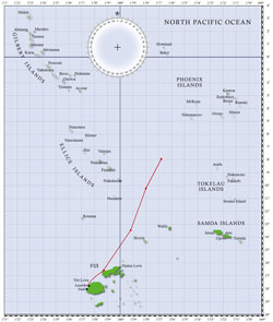
Dateline: 10 June 2015, 18:40 EDT. 10°15′S, 178°W
Just over halfway to Niku. ETA is now Saturday at dawn, local time (about 2 p.m. Friday EDT). About a half day ahead of the original schedule. Still rockin’ and rollin’ but making good time.
On arrival, the first order of business will be to set a mooring to the Norwich City. The inflatable boat can’t go into the channel until high tide, which will be mid-afternoon local time, so there will be time for a walkabout in the Village and some familiarization for the new people.
Satellite communications for the expedition are set up and working well. An Iridium Pilot Open Port broadband station was tested while still stateside, the antenna for which was re-erected aboard Nai’a atop a temporary 3 meter pole provided by the crew. A expedition communications station has been placed in the salon. Also at the comm station is the Amateur Radio station which will be used to simulate post loss distress calls. That portion of the comm station will be enhanced after we arrive at Nikumaroro. Contacts for initial testing have been made on the 20 meter band while under way to Arizona, Indiana, Puerto Rico, California, Japan and Australia.
For nearly a week after Earhart disappeared radio distress calls were heard on her primary frequencies by many stations around the Pacific. Signals were also heard by members of the general public on their home shortwave sets in several locations around the U.S. and Canada on harmonics of her frequencies. During the Niku VIII expedition we will broadcast simulations of some of the reported distress calls on a frequency close to one of the harmonics using an antenna rigged to simulate the characteristics of the transmitting antenna. Anyone with a shortwave radio is encouraged to listen in and let us know if you picked up the signal.
Route map: click on the map to open a larger version on a new page.
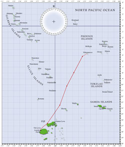
Dateline: 9 June 2015, 20:30 EDT. 13°48.1′S, 179°20.0′W
Approximately 615 NM from Nikumaroro, making 9.5 knots. At this rate, landfall Nikumaroro will be about sunup on Saturday, June 13. The seas are rough and Nai’a is rockin’ and rollin’. There are a few experienced sailors aboard, but otherwise it’s the ship of the living dead. Two choices: take your meds and sleep, or don’t take your meds and... Well.
Route map: click on the map to open a larger version on a new page.
Dateline: 8 June 2015, 18:45 EDT. 16°35′S, 178°43.5′E
Ric called, from Nai’a, on the satellite telephone system, at sea. This is a first! Remembering the first Earhart Project expedition ... the only communication from the island back to the U.S. was ham radio. Now we can just pick up the telephone.
They are coasting the the northern shore of Vanua Levu and will exit Fijian sheltered waters tonight, and with it exit the calm seas. Making more than 8 knots, they are hoping that the increase in wind will let them hoist the sail and pick up another knot or two. If so, they could possibly reach Nikumaroro a day early, on the morning of the 12th. That would be great, giving them an extra full day on site; but nothing whatsoever is certain at sea, and this is purely speculation right now.
The ship is busy as a hive of bees, with everyone setting up, testing, fixing, testing, re-arranging, testing – in between meals and exercise. Yes, our tri-athletes have set up a gym on the foredeck with resistance bands and the like, and are working out. One team member has a marathon two days after arriving home, another a triathlon four days after, so they are trying to stay in shape on the voyage.
Everything is going great and everyone is happy.
Route map: click on the map to open a larger version on a new page.
Our special thanks to the corporate
and individual sponsors of The Earhart Project, without whom nothing would
be possible:
The
Earhart Project is funded by charitable contributions. Donations by check
(payable to TIGHAR) or credit card (Visa, Discover, American Express or Master Card) may be sent to TIGHAR,
The Earhart Project, 2366 Hickory Hill Road, Oxford, PA 19363, USA, or click on
the link above to make your contribution. Confidential inquiries regarding
sponsorship opportunities for individuals or corporations should be addressed
to Executive Director Richard Gillespie (email Ric@tighar.org).
Copyright 2021 by TIGHAR, a non-profit foundation.
No portion of the TIGHAR Website may be reproduced by xerographic,
photographic, digital or any other means for any purpose. No portion
of the TIGHAR Website may be stored in a retrieval system, copied,
transmitted or transferred in any form or by any means, whether electronic,
mechanical, digital, photographic, magnetic or otherwise, for any purpose
without the express, written permission of TIGHAR. All rights reserved.