 |


Follow the team around Nikumaroro
with the Grid Map Set.During the time the expedition is at Nikumaroro, the TIGHAR website will carry daily updates of where the teams are working, how everyone is doing, and what they’re finding.
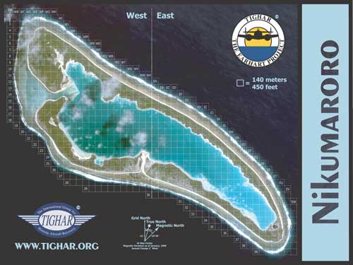
In 2001, we offered TIGHAR members a special poster-size grid map of Nikumaroro based on a beautiful satellite photo of the island by Space Imaging. We’re making those maps available again this time, plus two new, detailed grid maps based on an even more hi-resolution satellite image of the island taken by Digital Globe earlier this year. We’re very grateful to Digital Globe for making this new imagery available.
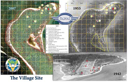
The two new maps provide up-close views of the village and the Seven Site, the two primary areas of focus for this expedition. In his daily reports, Ric will reference the grid coordinates and features detailed on the maps. Historical photos included on each sheet show structures and features as they appeared in the past and provide perspective on how the island has changed over the years.
This is the original grid map, put together in 2001 for Niku IIII. The grid was transferred to the two new maps so that there is an exact correspondence. |
|
 |
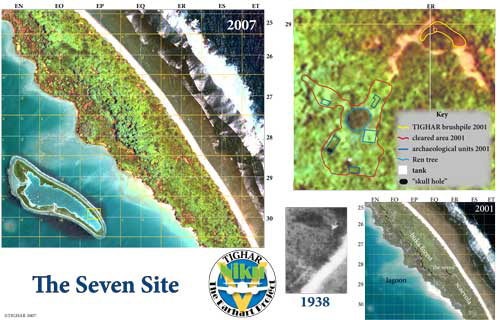 |
| The village site, with outlines comparing the shore in 1953 and 2007, and structures carried from 1942 through 1953 to their locations (although destroyed) in 2007. | The Seven Site, with a summary of the work done in 2001 and outlines of interesting features from 1938 and 2007. |
These new maps are great tools for understanding the island and keeping track of the expedition’s progress. They’re also very attractive and informative in their own right.
TIGHAR incurred considerable debt to make this expedition possible. Your contributions have reduced the shortfall but we’re still in the hole. In appreciation for your $100 donation we’ll send you all three full-color grid maps:
» the entire island (18 x 24)
» the village archeological area (11 x 17)
» the Seven Site archaeological area (11 x 17)Click HERE to order on line.
TIGHAR is a 501(c)(3) public charity. All contributions are tax deductible to the full extent of the law.
 |
Copyright 2021 by TIGHAR, a non-profit foundation. No portion of the TIGHAR Website may be reproduced by xerographic, photographic, digital or any other means for any purpose. No portion of the TIGHAR Website may be stored in a retrieval system, copied, transmitted or transferred in any form or by any means, whether electronic, mechanical, digital, photographic, magnetic or otherwise, for any purpose without the express, written permission of TIGHAR. All rights reserved. Contact us at: info@tighar.org • Phone: 610.467.1937 • JOIN NOW |