Maps of Nikumaroro: Difference between revisions
Jump to navigation
Jump to search
No edit summary |
No edit summary |
||
| Line 6: | Line 6: | ||
Image:nikumapevidence.gif| nikumapevidence.gif | Image:nikumapevidence.gif| nikumapevidence.gif | ||
Image:nikumapevidence.jpg| nikumapevidence.jpg | Image:nikumapevidence.jpg| nikumapevidence.jpg | ||
Image:nikumapfred.jpg| nikumapfred.jpg | Image:nikumapfred.jpg| nikumapfred.jpg | ||
Image:nikumapplain.jpg| nikumapplain.jpg | Image:nikumapplain.jpg| nikumapplain.jpg | ||
| Line 15: | Line 14: | ||
Image:Nikusunrise.jpg| Nikusunrise.jpg | Image:Nikusunrise.jpg| Nikusunrise.jpg | ||
Image:phoenixgroup.gif| phoenixgroup.gif | Image:phoenixgroup.gif| phoenixgroup.gif | ||
Image:phoenixmap.gif| phoenixmap.gif | Image:phoenixmap.gif| phoenixmap.gif | ||
Image:siteloc.jpg| siteloc.jpg | Image:siteloc.jpg| siteloc.jpg | ||
Revision as of 04:52, 7 February 2009

Map Gallery
-
nikumap.jpg
-
nikumapanno.jpg
-
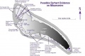
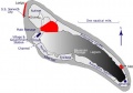
nikumapevidence.gif
-
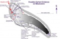
nikumapevidence.jpg
-

nikumapfred.jpg
-

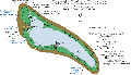
nikumapplain.jpg
-
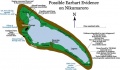
nikumapplain2.jpg
-
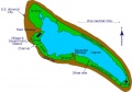
Nikumaroro.jpg
-
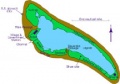
Nikumarorosmall.jpg
-
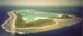
nikupic.jpg
-
Nikusunrise.jpg
-
phoenixgroup.gif
-
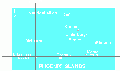
phoenixmap.gif
-

siteloc.jpg


Google Earth .kmz files
To use .kmz files you must have Google Earth installed on your computer. Save the .kmz file on your computer where you can find it. Start Google Earth, select File / Open and then browse to the saved .kmz file. Nikumaroro will come into view.