The Village: Difference between revisions
Rickerjones (talk | contribs) mNo edit summary |
Rickerjones (talk | contribs) mNo edit summary |
||
| Line 11: | Line 11: | ||
File:Village kmz.png|KMZ Google Earth image. | File:Village kmz.png|KMZ Google Earth image. | ||
</gallery> | </gallery> | ||
[[Category:Nikumaroro]] | [[Category:Nikumaroro|Village]] | ||
[[Category:Maps|Village]] | [[Category:Maps|Village]] | ||
Revision as of 15:44, 12 June 2010
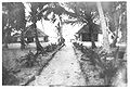
There are really (at least) three or four "village" areas. The Government Station is up in the tip of the dog-nose pointing into the lagoon along the south shore of Tatiman Passage. There's the old village, which actually moved and morphed but was basically peripheral to the Government Station, north of the blasted channel. There's the Gallagher Highway area, running between the blasted channel and the lagoon, where there were a number of later government and other facilities (e.g. the school), and there's the "new village" or "Laxton-era" village that began south of the Government Station and extended down for some distance across and south from the Gallagher Highway area, along a N-S tending road, to the maneaba on the lagoon shore well southeast of the blasted channel.
-

-

-

1939--from Northeast.
-
-

-

KMZ Google Earth image.


