Site of Norwich City Rescue: Difference between revisions
(→Links) |
|||
| (9 intermediate revisions by the same user not shown) | |||
| Line 182: | Line 182: | ||
:* 21 survivors and 3 or 4 boatmen. | :* 21 survivors and 3 or 4 boatmen. | ||
:* Natives started fire and cooked crabs and birds. | :* Natives started fire and cooked crabs and birds. | ||
== Weather conditions == | |||
''Hamer'': | |||
* "Strong westerly wind and high seas were striking the ship and she was pounding heavily on the reef so that men coming along the deck were thrown in all directions." | |||
''Lott'': | |||
* "At the time of the wreck [2300 Fri 29 Nov] it was raining hard and wind from the westward, blowing hard. It rained hard right through the following day [Sat 30 Nov]. After that it was showery and hot." | |||
== Conflicting Interpretations of the Data == | == Conflicting Interpretations of the Data == | ||
The meaning of several terms are disputed: | The meaning of several terms are disputed: | ||
1. What did Swindell mean by "the southeast corner of the island"? | |||
2. What did Lott mean by "the lee side"? | |||
3. What did the witnesses mean when they referred to the skiff going "across the lagoon"? | |||
=== Camp 3 in Tekibeia === | === Camp 3 in Tekibeia === | ||
; The "southeast corner of the island" would mean the first corner of the island as seen from the Trongate's perspective one-half mile off of the Norwich City wreck. | The argument for camp 3 in [[Tekibeia]] is presented in a different form in the article on the [[Norwich City Survivors' Shelter|''Norwich City'' Survivors' Shelter.]] | ||
; 1. The "southeast corner of the island" would mean the first corner of the island as seen from the Trongate's perspective one-half mile off of the Norwich City wreck. | |||
The existence of this "corner" is what provides shelter from the northwest wind; this, in turn, helps to explain the interpretation given here of "the lee side of the island." | The existence of this "corner" is what provides shelter from the northwest wind; this, in turn, helps to explain the interpretation given here of "the lee side of the island." | ||
:[[File:Trongate_perspective.png|600px]] | :[[File:Trongate_perspective.png|600px]] | ||
[http://tighar.org/smf/index.php/topic,677.msg13257.html#msg13257 Andrew McKenna argues] that the only place to see the skiff heading toward the southeast is through one of the passages into the lagoon: | |||
:: I've said before, and Gregory Daspit mentions it in his email, you cannot see out of or into the lagoon anywhere except the two passages mentioned above, so the only way for the ship to see the surf boat is if it happened to be outside one of the passages looking in. If the surf boat had continued down to the SE end of the lagoon as you suggest, the boats would not have been able to see the ship, and vice versa. That is not a recipe for rescue and I can't see anyone thinking that being out of visual contact with your rescuers was a good plan. | |||
:: The only logical solution is to exit at Tatiman or Baureke passage, and get rescued. Look at the timeline, they go aground on Friday night. The Trongate and the L. Ellsworth arrive on Tuesday at 8am ish. After launching the surf boat ashore, the next thing the ships do is find a better place some 1.5 miles down the beach from the wreck. Later that same day, they "cross the lagoon in the boat to where the vessels were waiting on the outside and transported the boat to edge of the reef. It was now about 2 p.m." So since the arrival of the ships, only 6 hours has passed. | |||
In making this drawing, I supposed, without evidence, that the narrowing of the land (and possibly lower vegetation there) might allow a view into the lagoon: | |||
:[[File:SE_corner.png|600px]] | :[[File:SE_corner.png|600px]] | ||
; The "lee side of the island" is taken to mean "all the shoreline that is sheltered from a northwest wind by the shape of the island." | [http://tighar.org/smf/index.php/topic,677.msg13257.html#msg13257 Andrew's argument] against a portage across Aukaraime North through the vegetation applies to the narrow areas indicated by arrows above as well: | ||
:: Nobody in their right mind would attempt to exit the lagoon and portage their boat through the dense underbrush across the island to the beach on the NE side. If they had, it would have been an extreme effort, and I would expect that adventure would have been reported in the records. Nobody mentions such activity. From personal experience, I can tell you that this would be a near impossible task without a bunch of cutting tools and a ton of water. In 2001, it took us two days to cut a trail from the lagoon to the ocean and that was with machetes and chain saws, and even then the trail was only wide enough for human traffic, not a surf boat. | |||
:[[File:Baureke exit.jpg|600px]] | |||
; 2. The "lee side of the island" is taken to mean "all the shoreline that is sheltered from a northwest wind by the shape of the island." | |||
:[[File:Leeward-side.png|600px]] | :[[File:Leeward-side.png|600px]] | ||
; "Across the lagoon" means from [[ | ; 3. "Across the lagoon" means from [[Noriti]] to [[Tekibeia]]. | ||
: The purpose of this drawing is to show that there is more than one way to cross the lagoon. The three leftmost lines are from Noriti to Tekibeia. Six of the lines lead "southeast" from Noriti. | |||
:[[File:Across.jpg|600px]] | :[[File:Across.jpg|600px]] | ||
| Line 211: | Line 235: | ||
=== Camp 3 at Seven Site === | === Camp 3 at Seven Site === | ||
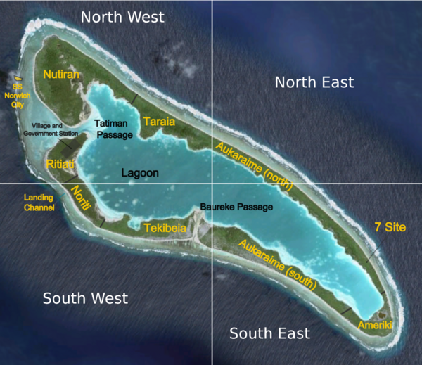
;The "southeast corner of the island" would mean Ameriki, as is easily recognized with modern maps. | ; 1. The "southeast corner of the island" would mean Ameriki, as is easily recognized with modern maps. | ||
:[[File:Niku-placenames-plus-quadrants.png|600px]] | :[[File:Niku-placenames-plus-quadrants.png|600px]] | ||
; The "lee side of the island" is taken to mean "the shoreline that near the Seven Site." | ; 2. The "lee side of the island" is taken to mean "the shoreline that near the Seven Site." | ||
; "Across the lagoon" means from [[Place Names|Noriti]] to the [[Seven Site]]. | ; 3. "Across the lagoon" means from [[Place Names|Noriti]] to the [[Seven Site]]. | ||
; Camp 3 is at the Seven Site. | ; Camp 3 is at the Seven Site. | ||
=== Failed crossing at Seven Site, Camp 3 in Tekibeia === | === Failed crossing at Seven Site, Camp 3 in Tekibeia === | ||
This theory was proposed as a compromise. It shares the | This theory was proposed as a [http://tighar.org/smf/index.php/topic,677.msg13236.html#msg13236 compromise.] It shares the interpretations of the witness statements of the theory that Camp 3 was at the Seven Site, but proposes that the rescue was effected offshore from [[Tekibeia]]. | ||
This scenario implies that: | |||
* 24 survivors were ferried to the [[Seven Site]] by boat. | |||
* The boat was carried across land to the reef. | |||
* The boat was carried overland back to the lagoon. | |||
* The survivors were ferried to [[Tekibeia]]. | |||
* The boat was carried overland to the reef. | |||
* Camp 3 was in or near [[Tekibeia]]. | |||
All of this would have been accomplished on Tuesday in the space of five or six hours. | |||
== References == | == References == | ||
| Line 238: | Line 272: | ||
* [http://tighar.org/Projects/Earhart/Archives/Documents/Norwich_City/NorwichCity5.html#7 Report of J. Thomas, First Officer, S.S. Norwich City.] | * [http://tighar.org/Projects/Earhart/Archives/Documents/Norwich_City/NorwichCity5.html#7 Report of J. Thomas, First Officer, S.S. Norwich City.] | ||
* [http://tighar.org/Projects/Earhart/Archives/Documents/Norwich_City/NorwichCity5.html#8 Crew List.] | * [http://tighar.org/Projects/Earhart/Archives/Documents/Norwich_City/NorwichCity5.html#8 Crew List.] | ||
* [http://trove.nla.gov.au/ndp/del/article/4057093 Melbourne ''Argus,'' "Wreck of the Norwich City," 16 Dec. 1929.] | |||
[[Category:Nikumaroro]] | [[Category:Nikumaroro]] | ||
[[Category:Maps|Norwich City]] | [[Category:Maps|Norwich City]] | ||
Latest revision as of 15:22, 15 May 2012
This is a companion article to the main entry on SS Norwich City. The purpose of this article is to sort out questions raised in the Forum about the rescue operations.
Norwich City Chronology
| |
| 2300 |
|
| |
| 0200 |
|
| 0400 |
|
| 0515 |
|
| 1030 |
|
| morning |
Hamer:
|
| 1400 | Trongate departed Apia. |
| |
Hamer:
| |
| |
| |
| |
| 0650 | Swindell:
|
| 0730 | Swindell:
Hamer:
|
| 0830 | Swindell:
|
| 0900-1430 | Swindell:
Hamer:
Swindell:
Lott:
Tichendorf:
Swindell:
Hamer:
Swindell:
|
| 1430 | Swindell:
|
| 1500 | Swindell:
Hamer:
|
| 1830 |
|
| 2000 | Swindell:
|
| |
| 0630 | Swindell:
|
| 0740 | Swindell:
|
| 0830 | Swindell:
|
| 1415 | Swindell:
|
| 1430 | Swindell:
|
| 1530 | Swindell:
|
Campsites
- Friday night
- no camp.
- Camp 1
-
- 100 yards inland
- Saturday night only.
- Camp 2
-
- Further inland.
- Water collected.
- Wooden frame covered by sails.
- Sunday and Monday nights.
- Camp 3
-
- 1.5 NM "south" of the wreck.
- Supplies and water requested and provided.
- Tuesday night only.
- 21 survivors and 3 or 4 boatmen.
- Natives started fire and cooked crabs and birds.
Weather conditions
Hamer:
- "Strong westerly wind and high seas were striking the ship and she was pounding heavily on the reef so that men coming along the deck were thrown in all directions."
Lott:
- "At the time of the wreck [2300 Fri 29 Nov] it was raining hard and wind from the westward, blowing hard. It rained hard right through the following day [Sat 30 Nov]. After that it was showery and hot."
Conflicting Interpretations of the Data
The meaning of several terms are disputed: 1. What did Swindell mean by "the southeast corner of the island"? 2. What did Lott mean by "the lee side"? 3. What did the witnesses mean when they referred to the skiff going "across the lagoon"?
Camp 3 in Tekibeia
The argument for camp 3 in Tekibeia is presented in a different form in the article on the Norwich City Survivors' Shelter.
- 1. The "southeast corner of the island" would mean the first corner of the island as seen from the Trongate's perspective one-half mile off of the Norwich City wreck.
The existence of this "corner" is what provides shelter from the northwest wind; this, in turn, helps to explain the interpretation given here of "the lee side of the island."

Andrew McKenna argues that the only place to see the skiff heading toward the southeast is through one of the passages into the lagoon:
- I've said before, and Gregory Daspit mentions it in his email, you cannot see out of or into the lagoon anywhere except the two passages mentioned above, so the only way for the ship to see the surf boat is if it happened to be outside one of the passages looking in. If the surf boat had continued down to the SE end of the lagoon as you suggest, the boats would not have been able to see the ship, and vice versa. That is not a recipe for rescue and I can't see anyone thinking that being out of visual contact with your rescuers was a good plan.
- The only logical solution is to exit at Tatiman or Baureke passage, and get rescued. Look at the timeline, they go aground on Friday night. The Trongate and the L. Ellsworth arrive on Tuesday at 8am ish. After launching the surf boat ashore, the next thing the ships do is find a better place some 1.5 miles down the beach from the wreck. Later that same day, they "cross the lagoon in the boat to where the vessels were waiting on the outside and transported the boat to edge of the reef. It was now about 2 p.m." So since the arrival of the ships, only 6 hours has passed.
In making this drawing, I supposed, without evidence, that the narrowing of the land (and possibly lower vegetation there) might allow a view into the lagoon:

Andrew's argument against a portage across Aukaraime North through the vegetation applies to the narrow areas indicated by arrows above as well:
- Nobody in their right mind would attempt to exit the lagoon and portage their boat through the dense underbrush across the island to the beach on the NE side. If they had, it would have been an extreme effort, and I would expect that adventure would have been reported in the records. Nobody mentions such activity. From personal experience, I can tell you that this would be a near impossible task without a bunch of cutting tools and a ton of water. In 2001, it took us two days to cut a trail from the lagoon to the ocean and that was with machetes and chain saws, and even then the trail was only wide enough for human traffic, not a surf boat.

- 2. The "lee side of the island" is taken to mean "all the shoreline that is sheltered from a northwest wind by the shape of the island."

- The purpose of this drawing is to show that there is more than one way to cross the lagoon. The three leftmost lines are from Noriti to Tekibeia. Six of the lines lead "southeast" from Noriti.

- The supposed sequence of camps then looks something like this:

Camp 3 at Seven Site
- 1. The "southeast corner of the island" would mean Ameriki, as is easily recognized with modern maps.

- 2. The "lee side of the island" is taken to mean "the shoreline that near the Seven Site."
- 3. "Across the lagoon" means from Noriti to the Seven Site.
- Camp 3 is at the Seven Site.
Failed crossing at Seven Site, Camp 3 in Tekibeia
This theory was proposed as a compromise. It shares the interpretations of the witness statements of the theory that Camp 3 was at the Seven Site, but proposes that the rescue was effected offshore from Tekibeia.
This scenario implies that:
- 24 survivors were ferried to the Seven Site by boat.
- The boat was carried across land to the reef.
- The boat was carried overland back to the lagoon.
- The survivors were ferried to Tekibeia.
- The boat was carried overland to the reef.
- Camp 3 was in or near Tekibeia.
All of this would have been accomplished on Tuesday in the space of five or six hours.
References
Links
- SS Norwich City.
- Norwich City Survivors' Shelter.
- Cover Letter to the Board of Trade, London.
- Statement of Henry Cleveland Lott, Second Officer, S.S. Norwich City.
- Statement of John Harry Swindell, Master, S.S. Trongate.
- Statement of Daniel Hamer, Master, S.S. Norwich City.
- Statutory Declaration by J. H. Swindell, Master, S.S. Trongate.
- Position Report describing condition and location of S.S. Norwich City.
- Report of J. Thomas, First Officer, S.S. Norwich City.
- Crew List.
- Melbourne Argus, "Wreck of the Norwich City," 16 Dec. 1929.