Earhart Project Research Bulletin #68
July 22, 2013
Lost & Found
A tin has been found in the archives of the Royal New Zealand Air Force containing forty-one aerial photographs of Gardner Island (now Nikumaroro) taken just fifteen months after the Earhart disappearance and before the first official inhabitation of the island.
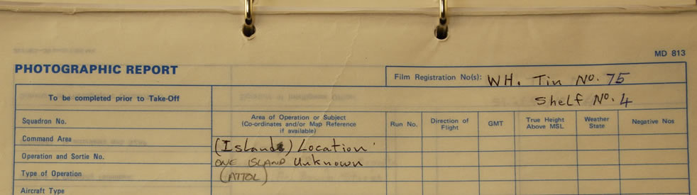
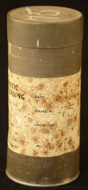
Matthew O’Sullivan, Keeper of Photographs at the New Zealand Air Force Museum in Christchurch, is a meticulous archivist. The thousands of photographs and negatives in the museum’s collection are carefully cataloged and stored so it bothered him that there was one can of aerial photo film – Tin No.75 – that was listed only as “(Island) Location, one island unknown, (attol).” TIGHAR photo by J. Glickman.
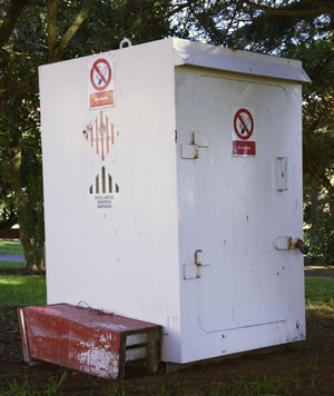
The can was not stored with most of the collection. For safety reasons, all of the old flammable nitrate negatives were kept in a metal locker under the trees outside the Restoration Hangar. TIGHAR photo by J. Glickman.
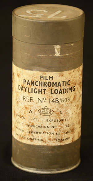
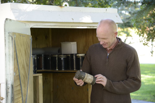
On June 11, 2013 Matthew had a request for some old negatives of Auckland that were on nitrate film so he had to get into the locker. As long as he was there he decided to see what was in the “unknown island” can. He found can #75. TIGHAR photo by J. Glickman.
The label was mottled with rust spots and there was no date. The penciled letters under “Location” were almost illegible but he could make out the faint words “Gardener Island” [sic]. He opened the can and found a roll of developed negatives and a set of 41 contact prints. A quick comparison of the images in the contact prints with Google Earth convinced him that the images were, indeed, detailed aerial photos of Gardner Island. Normally Matt would have simply corrected the archival records and left it at that but serendipity dictated otherwise.
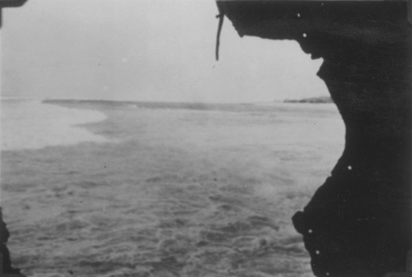
Just a few weeks before, TIGHAR’s Ric Gillespie had purchased a high resolution scan of a photo in the museum’s collection. It was part of a scrapbook of photos taken by the New Zealand survey party that mapped Gardner Island in late 1938/early 1939. These were on-the-ground photos taken by the surveyors and showed various island scenes. The museum had only copy-photos of the pages in the scrapbook, (nobody knows where the original scrapbook is) and TIGHAR had gotten copy negatives of the copy-photos from the museum in 2000. One photo was taken through a hole in the hull of the Norwich City shipwreck looking north along reef. Ric and forensic imaging specialist Jeff Glickman hoped that a better copy of the photo might show objects of interest on the reef – but it didn’t.
For TIGHAR it was another dead end, but the transaction meant that when Matt found the aerial photos of Gardner Island, TIGHAR’s investigation was fresh in his mind. He sent an email to Ric with scans of the contact sheets.
I don't have a date but it will be early WW2 at the latest. … If this film proves to be of interest you may well wish to come here and examine it yourself.
I look forward to your reply.
Matthew O’Sullivan
Keeper of Photographs
Ric replied:
Matt,
These photos are a gold mine. I know exactly what they are. What you have discovered is the complete set of aerial obliques taken on December 1, 1938 by a Supermarine Walrus launched from HMS Leander in support of the New Zealand Pacific Aviation Survey. … The fact that you have the 5 inch negatives is fortunate beyond measure.
We are delighted to accept your invitation to come and examine the negatives in person.
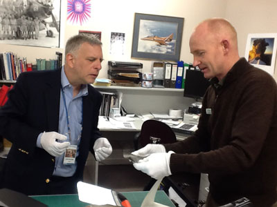
Ric Gillespie and Jeff Glickman arrived in Christchurch, New Zealand on July 10 and spent that day and the next making copies of the negatives. Matthew O’Sullivan was a gracious host and worked closely with Ric and Jeff to help assure that they came away with the best-possible copies. With his help and with research by members of the TIGHAR Amelia Earhart Search Forum, we’ve been able to piece together the fascinating story of how these photographs were taken. TIGHAR photo by R. Gillespie.
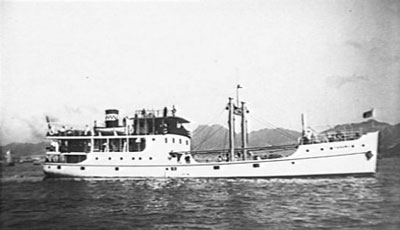
In 1938 the New Zealand Pacific Aviation Survey mapped British-owned atolls of the South Central Pacific to evaluate their suitability for the construction of airfields and assess their lagoons as possible bases for flying boats. The mapping of Gardner Island was done by a 12-man survey team transported aboard the chartered motor vessel M/V Yanawai. Photo courtesy Australian War Memorial.
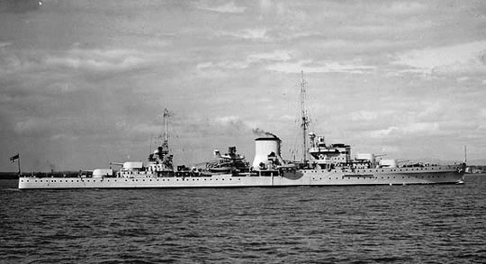
The survey was augmented with aerial photographs taken from an aircraft carried aboard the cruiser HMS Leander (left) in service to the Royal Navy’s New Zealand Division. Photo courtesy Royal Navy.
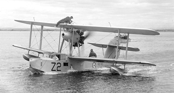
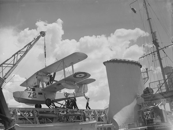
Leander’s aircraft was Supermarine Walrus I, K5783, Code Z2 (some sources say Z4 but Z2 seems to be correct). When used for aerial photography, the photographer rode in the compartment behind and below the pilot, shooting through the open windows on each side of the fuselage. Photo courtesy Royal Navy.
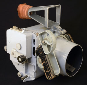
The aerial photos were shot using a Type F24 Aerial Camera. This example is in the New Zealand Air Force Museum Collection in Christchurch. TIGHAR photo.
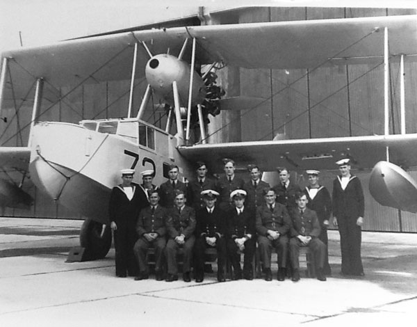
Leander’s aviation section was made up of both Royal Navy New Zealand Division and Royal New Zealand Air Force personnel (note the different uniforms). It was the practice at that time for all aerial photography to be carried out by the Air Force so the flight and maintenance crew were RN and the photo technicians were RNZAF. RNZAF official photo.
Normally the aircraft was catapulted from the cruiser’s deck and landed in the ocean to be recovered by crane, but on November 24, 1938, during operations at Christmas Island, there was a mishap that resulting in the catapult mechanism being lost overboard (sounds exciting). Subsequent flight operations required calm enough water that the Walrus could be lowered over the side with the crane and take off from the ocean. Photo courtesy Royal Navy.
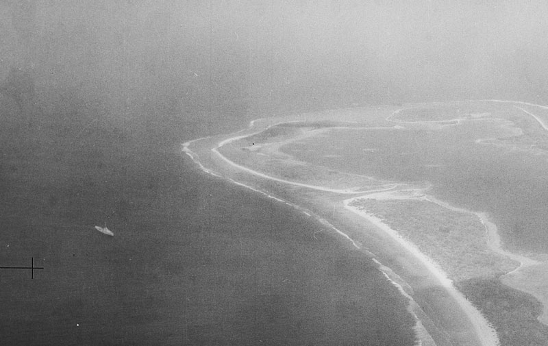
M/V Yanawai with the survey party aboard arrived at Gardner on November 30, 1938 but was unable to find an anchorage. The best plan seemed to be to land supplies on the reef in the lee of SS Norwich City, the British freighter that had run aground in a storm and burned in 1929. In the aerial photos taken the next day, Yanawai can be seen standing off the west end not far from Norwich City. RNZAF official photo.
HMS Leander arrived on the morning of December 1, 1938 and took up a position off the southern end of the island where the water is calmest. The Walrus was launched and began its photo mission. RNZAF official photo.
From TIGHAR’s perspective the 41 aerial photos taken that day captured Gardner Island at a particularly auspicious moment. The Earhart Electra had vanished 18 months earlier. Three weeks after the photos were taken the first colonists of the Phoenix Islands Settlement Scheme would arrive and begin clearing land for a village. The island would eventually host a colony of over one hundred settlers and, during WWII, a U.S. Coast Guard Loran station, but the photos taken by the New Zealand Air Force cameraman on December 1, 1938 show us an island that had experienced only occasional recorded human contact since it was named by American whalers in the early years of the 19th century.
Although unknown to the New Zealand Pacific Aviation Survey, Gardner Island did have at least one recent resident. In 1940, the bones of a castaway would be found at a makeshift campsite on the island’s remote southeast end – a castaway suspected at the time to be Amelia Earhart. A growing body of archival and physical evidence suggests that suspicion was correct.
By the time the aerial photos were taken the castaway was probably dead. The survey party did not become a rescue party. They found the island to be desiccated by a severe drought that had caused most of the trees to shed their leaves, but that too was fortunate for TIGHAR’s investigation because more of the ground is visible in the aerial photos.
The importance of this series of negatives to The Earhart Project is difficult to overstate. For the past 25 years, historical photos of the island have been key elements in our investigation but we have always had to tease information from second or third generation copies. Never before have we had access to high-quality original source photographic material. The imagery we examined and copied at the New Zealand Air Force Museum is on the actual film that was in the F24 Aerial Camera aboard the Walrus that day in 1938. It was probably developed aboard Leander and a set of contact prints made. The contact prints were probably referenced when the island map was drawn but the roll of negatives was never cut into individual frames. Because the roll of fine-grained, large-format film remained in the original can, it did not get scratched or defaced through careless handling. The roll was not cut until Matthew O’Sullivan prepared the film for TIGHAR to copy.
This new research resource is a time capsule that allows us to explore the island as it was 75 years ago. What we’ll learn remains to be seen. Of course we’ll look for signs of human activity at the Seven Site and elsewhere. We’ll look for possible signs of aircraft wreckage on the reef and beach, but as with all exploring, it will be important to not just look for what we think might be there but to also keep our eye out for the unexpected. Fortunately we have multiple views of each part of the island, so we can verify that an object of interest is not a speck of dust or flaw in the developing process – always a major concern when working from a single image.
The images we copied at the New Zealand Air Force Museum are owned by the New Zealand Air Force and the copies we made are approved only for TIGHAR research. We can publish our research results, properly crediting the photos to “RNZAF Official Photo,” but we can’t just release all of the photos to the general public and, of course, we can’t sell them. We can, however, make high resolution copies available to TIGHAR researchers. If you are a TIGHAR member at the TIGHAResearcher level or above, and you would like access to high resolution JPEGs of the 1938 aerial photos, please send your request to Pat.
Copyright 2021 by TIGHAR, a non-profit foundation.
No portion of the TIGHAR Website may be reproduced by xerographic,
photographic, digital or any other means for any purpose. No portion
of the TIGHAR Website may be stored in a retrieval system, copied,
transmitted or transferred in any form or by any means, whether electronic,
mechanical, digital, photographic, magnetic or otherwise, for any purpose
without the express, written permission of TIGHAR. All rights reserved.