|
February 20, 2002
| RMS Titanic versus NR16020 |
Assumptions:
- Aircraft is 100 nm from Howland at 20:13 GCT (based on strength of last message received by Itasca).
- Four hours fuel remaining at 20:13 GCT (based on known fuel load at takeoff, Lockheed fuel consumption tables, and known time en route).
- Altitude 1,000 ft as reported to Itasca.
- Airspeed 110 kts. Fuel consumption 38 GPH. (Twenty knots have been subtractedc from the flight-planned cruising speed of 130 kts which assumed an altitude of 10,000 ft.)
- Weather, scattered cumulus at 2650 feet. Wind ESE at 15 (actual weather observation at Howland Island).
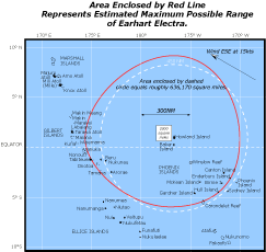
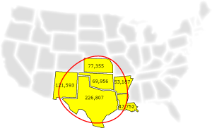
636,000 square miles is approximately this much area:
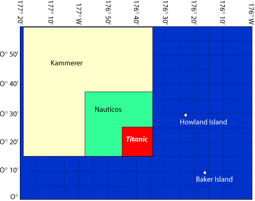
Constraining the search area to practical limits requires that guesses be made about what actually happened. We at TIGHAR, for example, launched our investigation in 1988 based upon the guess (or “hypothesis” if you prefer more syllables) that the flight had flown down the navigational line Earhart had said they were following and had landed at Gardner Island (now Nikumaroro). Searches of that location have uncovered compelling, but not yet conclusive, evidence that our guess is correct. All of the proposed deep water searches are based upon Elgen Long’s guess that the airplane ran out of gas very shortly after 08:43 that morning and that it is possible to reconstruct, within searchable limits, where the airplane was when that happened—hence, the 2,000 square mile search area.
Nauticos, in fact, is willing to pile the guesses higher and feels that the search area can be narrowed to a mere 500 square miles. In the 1986 Titanic search, the primary area covered by the French research vessel Le Suroit and the American ship Knorr, was 100 square miles, and the ship was only found after the French sonar search had failed and Dr. Ballard’s team aboard the Knorr decided to cover one last corner with a visual search using the Remote Operated Vehicle (ROV) “Argo.”
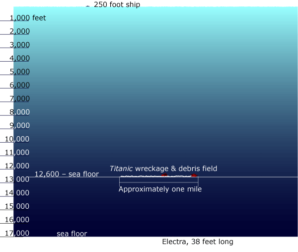
More daunting, perhaps, than the immensity of the proposed search area is the tininess of the target. What Ballard’s team initially found was not the sunken ship but part of the mile-long trail of debris deposited when the ship broke up as it sank. Not only is the lost Lockheed infinitely smaller than the aptly-named Titanic, but there will be no traceable debris field to stumble across even if the plane did not remain intact as Elgen Long supposes it did – and remember, the sea floor in the proposed search area is more than a mile deeper than where the Titanic was found.
Think of it this way: Climb aboard a blimp and take it up to 17,000 feet (remember to put on your oxygen mask). Look down and see if you can pick out that Lockheed Electra parked on the airport three miles below (did you bring your binoculars?). Now look out toward the horizon and imagine a square of countryside that’s about 45 miles on each side. Your job is to find a crashed Electra somewhere out there and the fastest you can go is 5 knots. Oh, and by the way, you have to do it in the dark. And there’s an excellent chance that it’s not there at all.