|
July 7, 2000
TIGHAR’s working hypothesis is that on July 2, 1937 the Earhart aircraft was landed on the reef-flat at Nikumaroro north of the shipwreck; that the landing left the aircraft intact enough to send radio signals for one or possibly two days; and that the aircraft was subsequently destroyed by wave action and the wreckage sufficiently scattered and obscured by the surf that it was not seen by the U.S. Navy’s aerial search one week later on July 9, 1937. This Research Bulletin will address two questions relevant to that hypothesis:
- Assuming that there has been no great change in the nature of the reef’s surface since 1937 (historical photos tend to support that assumption), where on the reef could a Lockheed Electra be landed without completely wrecking the airplane?
- Does the position of suspected wreckage appearing in an October 1937 photo correspond to the “landable” portion of the reef?
Question #1
Where on the reef could a Lockheed Electra be landed without completely wrecking the airplane?
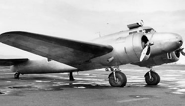 |
As with most aircraft of the 1930s, the Lockheed Model 10’s design anticipated operations from rough, unimproved surfaces. The tires were large in proportion to the aircraft – 35 inches in diameter x 15 inches wide – (by comparison, a typical pick-up truck tire is about 26x8) and the massive landing gear legs were welded castings of chrome molybdenum steel. Also, the aircraft’s conventional tailwheel landing gear arrangement was less prone to nose-over accidents than today’s more prevalent tricycle (nosewheel) configuration. Perturbations in the landing surface of six inches or eight inches would likely be uncomfortable and, if sharp, cause a blowout but should not flip the aircraft or cause the gear to fail. A depression a foot deep or more, on the other hand, would be a serious matter. |
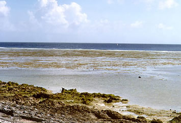
| The smoothness or roughness of the reef-flat north of the shipwreck at Nikumaroro varies considerably due to forces and factors we do not entirely understand. The delineation of the “landable” portion of the reef-flat in the illustration at right is based upon direct observation on the ground in 1999. The yellow dot near the south end of the landable area represents a Lockheed Electra to scale. | 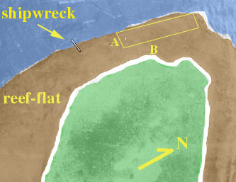 |
 |
|
| In the photo at left the camera is at position A looking north along the landable area. The breakers in the distance are approximately 2,000 feet away. The person standing on the point at B is roughly 800 feet away. The perturbations in the reef surface in the foreground average about 4 inches. | |
 |
|
| In the photo at right the camera is at B looking westward across the reef-flat. | |
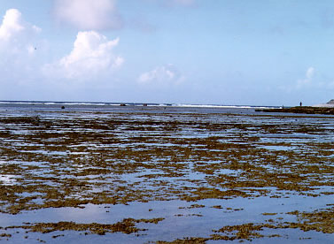
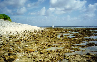
| The photo below looks southwestward and shows the deeply pitted surface of the reef-flat near shore. It shows that while the beach may at first seem to be a more attractive place to land an airplane, closer inspection shows it to be rather steeply sloped and covered with loose coral rubble. | |
 |
|
Question #2
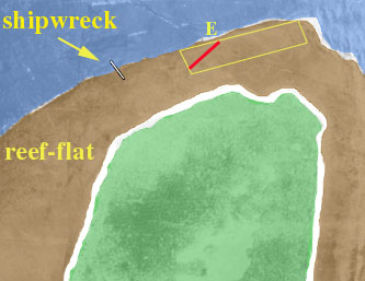
Does the position of suspected wreckage appearing in an October 1937 photo correspond to the landable portion of the reef?
A photo was taken to show the shipwreck and the island coastline but it also happens to show unidentified objects on the reef.
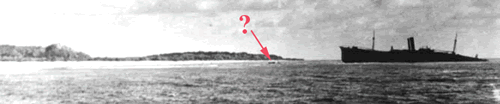
By aligning the relative position of identifiable landmarks in the photo it is possible to determine a line along which the unidentified objects must fall. As shown below, the objects in the 1937 photo are on a line (shown in red) which corresponds with a portion of the landable part of the reef. The location means that the objects in the photo are almost certainly not debris from the shipwreck, the wreckage from which is distributed exclusively in a southeasterly direction. The location does, however, match that marked on a map by Emily Sikuli (E) to indicate where she saw airplane wreckage in 1940.