 |
3/10/2000
Whether or not there were bones found other than the partial skeleton collected by Gerald Gallagher is still a matter of debate. What is not in dispute is that the young Colonial Service officer found human remains that possibly, even probably, were those of Amelia Earhart. If we can pinpoint where on the island Gallagher’s discovery was made we can conduct a thorough search and perhaps find more material. But that is easier said than done.
As far as we know, Gallagher never marked a map or provided a detailed description of exactly where he found the bones. Instead, he made passing references in various correspondence from which we must assemble our treasure map.
On October 6, 1940 in response to a question from the Resident Commissioner as to how far from shore the bones were found, Gallagher says:
“100 feet from high water ordinary springs”
On October 17, 1940 in response to a question from the Secretary of the High Commission as to where the bones were found, Gallagher says:
“Bones were found on South East corner of island about 100 feet above ordinary high water springs...”
The problem here is figuring out how broadly he is defining the “South East corner” of the island.
In the same communication Gallagher says:
“Body had obviously been lying under a ‘ren’ tree and remains of fire, turtle and dead birds appear to indicate life.”
In the same communication Gallagher says:
“All small bones have been removed by giant coconut crabs which have also damaged larger ones.”
Whether or not the scattering was actually done by coconut crabs, Gallagher obviously thought that there were crabs in the area. Birgus latro much prefers the shady forests to the harsher, more open parts of the island—but then, logically, so would a castaway.
In the same communication Gallagher says:
“… this part of island is not yet cleared”
In Gallagher’s letter that accompanied the bones and artifacts to Fiji, dated December 27, 1940 he says:
“… found on the South Eastern shore of Gardner Island”
In the same letter Gallagher says:
“… the skull has been buried in damp ground for nearly a year”
In the same letter Gallagher says:
“… something may come to hand during the course of the next few months when the area in question will be again thoroughly examined during the course of planting operations, which will involve a certain amount of digging in the vicinity”
Clearly, the area in question was scheduled to be planted. Whether those plans were ever carried out is another question.
In the same letter Gallagher says:
“… the coffin in which the remains are contained is made from a local wood known as ‘kanawa’ and the tree was, until a year ago, growing on the edge of the lagoon, not very far from the spot where the deceased was found.”
In a note to the file in Fiji on July 3, 1941 Gallagher wrote:
“There was no evidence of any attempt to dig a well and the wretched man presumably died of thirst. Less than two miles away there is a small grove of coconut trees which would have been sufficient to keep him alive if he had only found it. He was separated from those trees, however, by an impenetrable [sic] belt of bush.”
From these and a few other sparse clues we have come up with three possible sites. Each fits Gallagher's formula in some ways, but not in others. Perhaps one of them is the right place or maybe none of them is. Here are the arguments pro and con for each one.
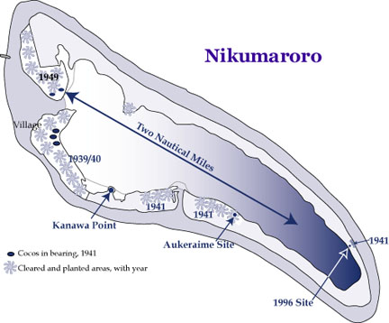
Kanawa Point
Pro:
Kanawa (Cordia subcordata) is a rare and valuable hardwood that once grew on Nikumaroro but is apparently now extinct, having been harvested out early in the colonial period. The specific mention of a kanawa tree growing on the lagoon shore close to the castaway’s campsite (No. 9 above) raises the suspicion that the site was on the one place on the island where we know that kanawa trees once grew in abundance. A small peninsula along the atoll’s southern shoreline appears as “Kanawa Point” on the map made by the 1938/39 New Zealand survey party for that reason. It was also said to be the scene of a strange encounter by the wife of the island’s first Native Magistrate, Teng Koata, with the atoll’s guardian spirit Nei Manganibuka (see “Kanawa Point” in TIGHAR Tracks Vol. 14, Nos. 1&2).Con:
By no stretch of the imagination is Kanawa Point on the south east corner (Point 2 above) or the south east shore of Nikumaroro (Point 6 above). Also, Kanawa Point was never planted to coconuts (see Point 8 above) and is within one mile, not two, of the nearest stand of coconut trees that were present in 1941 (see Point 10 above).Summary:
Favoring Kanawa Point: Points 5, 9.
Against Kanawa Point: Points 2, 6, 8,
10.
Assessment: TIGHAR has found no artifacts on Kanawa Point but neither have we conducted any kind of real search there. Although it was probably once open and quite pleasant, it is now thickly overgrown with dense scaevola underbrush. An organized inspection of Kanawa Point would be a labor intensive and time consuming enterprise. With so little going for it, a search of Kanawa Point now seems to be a low priority.
The Aukeraime Site
Pro:
 This
is the location where, in 1991, TIGHAR found the heel, fragmented sole,
and one brass shoelace eyelet from what appears to have been a shoe identical
in type, vintage, and size to those worn by Earhart on her final flight.
Nearby was the heel from a different pair of shoes. Given that Gallagher
also found the partial sole of a “woman’s stoutish walking shoe” and some
portion of a man’s shoe, this would seem to be a strong indication that
we’re in the right neighborhood. The place where we found the shoe parts
is near the lagoon shore and it is certainly possible that a kanawa tree
once grew there (Point 9). Our find was made a bit more
than 100 feet above the usual high tide line; however, it’s also clear
that we found shoes that Gallagher didn’t find, so the site of his discovery
could be a bit closer to the lagoon (Point 1). The Aukeraime
site is on the southeastern part of the island (Point 6)
and we know that the area was cleared for planting by June of 1941 (Point
8). The nearest stand of cocos in 1941 was just under two miles away
(Point 10).
This
is the location where, in 1991, TIGHAR found the heel, fragmented sole,
and one brass shoelace eyelet from what appears to have been a shoe identical
in type, vintage, and size to those worn by Earhart on her final flight.
Nearby was the heel from a different pair of shoes. Given that Gallagher
also found the partial sole of a “woman’s stoutish walking shoe” and some
portion of a man’s shoe, this would seem to be a strong indication that
we’re in the right neighborhood. The place where we found the shoe parts
is near the lagoon shore and it is certainly possible that a kanawa tree
once grew there (Point 9). Our find was made a bit more
than 100 feet above the usual high tide line; however, it’s also clear
that we found shoes that Gallagher didn’t find, so the site of his discovery
could be a bit closer to the lagoon (Point 1). The Aukeraime
site is on the southeastern part of the island (Point 6)
and we know that the area was cleared for planting by June of 1941 (Point
8). The nearest stand of cocos in 1941 was just under two miles away
(Point 10).
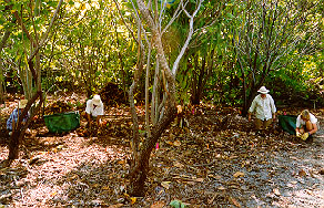
Above: Work in progress at the Aukeraime Site, 1997. TIGHAR photo by P. Thrasher.
Con:
Although on the southeastern shore, the Aukeraime site is nowhere near the southeast “corner” of the island (Point 2). Another more speculative argument against this site is that the width of the land mass between lagoon shore and ocean beach is about 400 meters and, presuming that the turtle was caught on the ocean beach, it is difficult to imagine a castaway dragging a several hundred pound turtle that far (Point 3).Summary:
Favoring the Aukeraime Site: Points 1,
6, 8, 9, 10.
Against the Aukeraime Site: Points 2, 3.
Assessment: Because the Aukeraime Site has appeared to be so promising as the place where the bones may have been originally found, TIGHAR devoted a considerable amount of time to detailed searches of the area during Niku II in 1991 and Niku III in 1997. Results have been disappointing. Aside from the shoe parts found in 1991, the only object of interest was a partially burned fragment of a paper can label found in the ashes and charcoal of a small fire uncovered in 1997. Subsequent analysis of the fragment has reliably dated it to relatively modern times and we now suspect that it, and the fire it was in, may be from a 1978 survey of the island by Kiribati authorities. A further examination of the Aukeraime Site would mean expanding the search area into the surrounding coconut jungle – a difficult prospect given the carpet of fallen nuts, some rotted, some rooted, which covers much of the ground.
The 1996 Site
TIGHAR’s attention was first drawn to this area in 1990 by anecdotal accounts from Coast Guard veterans who told of coming upon an abandoned “water collection device&rrdquo; while out exploring along the island’s northern shore. The device was said to consist of a tank, possibly metal, with a covering of some kind rigged above it on poles so that rainwater would drain into it. There was said to be a pile of bird bones and feathers nearby and a place where there had been a small fire. We speculated that this could be a survival camp with a cistern fabricated from one of the aircraft’s fuel tanks and, during Niku II in 1991 we made a concerted but unsuccessful effort to find it. Late in 1995, at TIGHAR’s request, Photek Inc. of Hood River, Oregon performed a forensic imaging analysis of aerial photographs of the area taken in 1941. The process revealed the presence of man-made objects in a particular spot within the suspect area. Guided by the enhanced photos, a short (4 days on the island) expedition to Nikumaroro in February 1996 succeeded in locating the site but we were disappointed to find that the tank and several other artifacts nearby were clearly associated with the British colonial settlement, not an aircraft. Detailed measurements were made and the objects and features found were photographed and videotaped. Five artifacts were collected (see below). It appeared that the expedition had disproved the hypothesis that the site had been an Earhart/Noonan survival camp. (See TIGHAR Tracks Vol. 12, No. 1 “The Niku III Preliminary Expedition.”)
Recently, however, TIGHAR Senior Archaeologist Dr. Tom King suggested another possible explanation for the material found at the 1996 Site. We had noted that by the time the bones and artifacts reached Fiji in the spring of 1941, a few items were present which had not been mentioned by Gallagher in his original notification in September of 1940 (namely, parts of a man’s shoe, “corks with brass chains” thought to have come from a “small cask,” and an “inverting eyepiece” for a sextant that was subsequently “thrown away by the finder”). It is, of course, possible that Gallagher merely neglected to mention these items in his original report but that seems rather unlikely given his apparent thoroughness. The other possibility is that the additional items were found later during further search operations. In a posting to TIGHAR’s Earhart Forum email research group, Tom King put it this way:
Gallagher, newly arrived on Niku, first reports the bones discovery on 23rd September 1940. He reports the skull, other bones, the shoe, and the sextant box, but not the inverting eyepiece or the corks on chains.
On 6th October, when he provides amplified details, he still doesn't mention them (but he's responding to specific questions).
On 17th October he still doesn't mention them, though by now he says "we" have "searched carefully." He opines that an "organized search" would take several weeks.
On 26th October Vaskess (Secretary of the High Commission) directs him to make an "organized search."
According to Gallagher's quarterly progress report for this period, "[t]he second half of the quarter was marked by severe and almost continuous North-Westerly gales, which did considerable damage to houses, coconut trees, and newly planted lands." The second half of this quarter would have been November-December. Hard to make an organized search.
On 27th December, however, he acknowledges the 26th October telegram and says that the bones and sextant box have been packaged for shipment to Fiji. The latter, he says, also "contains all the other pieces of evidence which were found in the proximity of the body."
So one wonders, was there a further, organized search during the second half of the last quarter of 1940, during breaks in the storms, which produced (perhaps among other things) the corks on chains? And if so, who did the searching? All the colonists? Some smaller group? Gallagher by himself? And does this suggest anything to us about where the search might have taken place? It would seem to argue against anyplace very far from the village--hard to travel very far in the heavy weather--unless one equipped oneself to go and stay for awhile. Which makes one wonder about the "house built for Gallagher" that Laxton (an administrator who visited the island in 1949) places on the southeast end of the island, and that is apparently represented by the water catcher seen by the Coast Guard and re-located by TIGHAR in 1996.----Tom King.
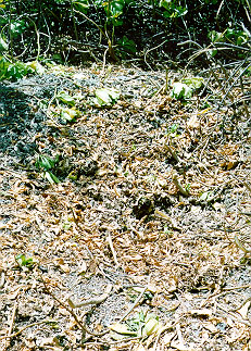
This interesting hypothesis has prompted a re-examination of the data collected in February 1996. The site is located on the northern coastline of the atoll about 1,000 meters from the extreme southeastern tip. In this area the ribbon of land surrounding the lagoon is at its narrowest, spanning only a little over 100 meters from lagoon shore to ocean beach. Today the region is solid scaevola (“te Mao”) with scattered Tournefortia argentia (“Ren”) but aerial photos show that in June 1941 there was a band of Pisonia grandis (“Buka”) behind the beachfront bulwark of scaevola. The presence of many old fallen Buka trunks today confirms that the area was once open forest such as still predominates just a few hundred meters further along the coastline to the northwest.
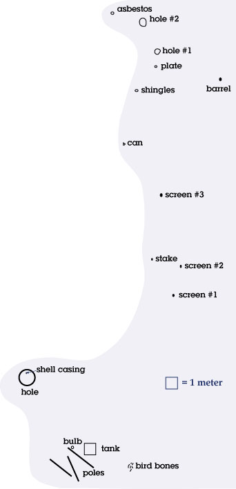
This is what we found in 1996:
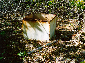 About
25 meters into the bush from the vegetation line along the lagoon shore
was a steel tank measuring 3 feet square by 4 feet high. It was painted
white with the words “Police” and “Tarawa” dimly legible in blue. The
corners and bottom were very rusty and the tank had not been watertight
for a long time. The top was open, apparently rusted away, and in the
bottom lay a steel ring which had clearly once been the fitting for a
heavy round steel hatch that lay on the ground nearby with the words “Baldwins
Ltd.–Tank Makers–London” molded into it. In the bottom of the tank were
six coconut shell halves which had apparently been used as drinking cups.
There were no coconut trees in the area.
About
25 meters into the bush from the vegetation line along the lagoon shore
was a steel tank measuring 3 feet square by 4 feet high. It was painted
white with the words “Police” and “Tarawa” dimly legible in blue. The
corners and bottom were very rusty and the tank had not been watertight
for a long time. The top was open, apparently rusted away, and in the
bottom lay a steel ring which had clearly once been the fitting for a
heavy round steel hatch that lay on the ground nearby with the words “Baldwins
Ltd.–Tank Makers–London” molded into it. In the bottom of the tank were
six coconut shell halves which had apparently been used as drinking cups.
There were no coconut trees in the area.
The water tank; note pole beside tank. TIGHAR photo by P. Thrasher.
On the ground beside the tank were three wooden poles, each roughly two meters long, a few very rusted scraps of corrugated metal, and the base of an unusual-looking light bulb (which we collected as Artifact 2-3-W-3). About three meters from the tank was a small Ren tree at the base of which was a scattering of very dry bird bones.
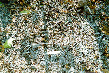
The bird bones with six inch scale in foreground. TIGHAR photo by P. Thrasher.
About seven meters from the tank, on the side away from the bird bones, was a depression in the ground roughly 3 meters across by less than a meter deep. The coral rubble in the bottom of the hole was quite loose, suggesting that the hole had once been deeper but the sides had slid down. At the time, we speculated that the hole represented an abortive attempt to dig a well. Lying amid the loose coral rubble in the bottom of the hole was a spent .30 caliber rifle cartridge with the number “43” on its base (collected as Artifact 2-3-W-4). This is consistent with the M-1 carbines carried by the Coast Guard and reportedly used to shoot at birds.
 A
half-dug well? Or the place where the skull was dug up? TIGHAR photo by
P. Thrasher.
A
half-dug well? Or the place where the skull was dug up? TIGHAR photo by
P. Thrasher.
Beginning about 15 meters from the tank, going toward the ocean beach, and scattered over the next 24 meters were:
- three small pieces of very fine copper screening. (Sample collected as 2-3-W-1)
- a dark brown four-hole button 15 mm (a little over a half inch) in diameter. Material uncertain. (Collected as 2-3-W-5)
- a broken finished wooden stake approximately 1 inch square in cross section and perhaps 18 inches long.
- an empty, very rusted can about the size and shape of a can of car wax.
- a flattened roll of tar paper with green roof shingle material on one side.
- an irregularly shaped sheet of asbestos (?) roughly 18 inches square by 1/4 inch thick (fragment collected as 2-3-W-2).
- the rusted remains of a steel barrel or drum.
- a broken shard from a white porcelain plate.
- near the plate shard were two holes in the ground about two meters apart which gave the impression of having once held poles upright, although no poles were in evidence.
Considering the hypothesis that the site, as surveyed in 1996, represents the original 1940 bone discovery site with an overlay of later material brought there to support the “organized search” ordered by the Western Pacific High Commission, we can subject the site to the same evaluation process we’ve used on the other two candidate sites.
Pro:
The 1996 Site is within a kilometer of the southeastern tip of the island and so would seem to match Gallagher’s description of being at the south east corner (Point 2) and on the south east shore (Point 6) of the island. An examination and comparison of aerial photos taken in 1937, 1938, 1939, and 1941 shows that the site remained uncleared (Point 5) until 1941 when clearing operations became evident on the ocean side but, curiously, not on the lagoon side. It appears that planting was contemplated (Point 8) but was never carried out, possibly as a consequence of Gallagher's death in September 1941.
The narrowness of the land mass at this point means that the site is both close to the lagoon shore (Point 9) and close to the ocean beach where turtles come ashore to lay their eggs (Point 3). The presence of bird bones at the site also fits Gallagher’s description but there is no way, at present, to determine whether the bird bones are the same ones seen by Gallagher and later the Coast Guardsmen, or may even be the bones of a bird shot with the bullet from the carbine shell casing found nearby. However, the presence of a Ren tree and the fact that the site is roughly 100 feet above the lagoon high tide line (Point 1) are interesting.
Of particular note is the excavation which we originally dismissed as someone’s abortive attempt to dig a well. Upon reflection, it bears little resemblance to known wells on the island and could, in fact, be where the skull which was buried by the work party that first found it, was later dug up at Gallagher’s direction (Point 7).
Map of Aukeraime Site:
Con:
The only aspect of Gallagher’s description of the bone discovery site that does not fit the 1996 Site is that the nearest stand of cocos in 1941 is more than two miles away (Point 10).
 1939
1939
1941
Summary:
Favoring the 1996 Site: Points 1, 2,
3, 5, 6, 7,
8, 9.
Against the 1996 site: Point 10.
Assessment: Based upon a straight quantification of the attributes described by Gallagher, the 1996 site would seem to be the most promising of the three candidate sites. But if the bones were originally found there, how did the shoes end up at the Aukeraime Site? Of course, any answer is purely speculative, but because we know that both sites were actively being worked in 1941 it seems possible that material found after Gallagher’s departure in early June may have been brought across the lagoon to Aukeraime. When Gallagher returned in late September he was gravely ill and died within three days. Further search operations at the 1996 Site will be difficult due to the remoteness of the area and the heavy scaevola growth, but we’re accustomed to dealing with those problems. One particularly attractive aspect of this site is that, unlike the other two candidate sites, it is remote from the settled part of the island and appears to be relatively undisturbed since Gallagher’s time. If the excavation we found there is, in fact, where the skull was exhumed, the possibility exists that one or more teeth may still be in the hole. Teeth can be an excellent source of mitochondrial DNA. If DNA from a tooth found in that hole were matched to that of Earhart’s living relatives we would have the conclusive proof we’ve been looking for, but for now it’s all just another hypothesis to be tested when we return to Nikumaroro.
