 |
2/23/00
There appears to be photographic evidence of recent human activity on Nikumaroro prior to the arrival of the island’s first settlers. There are marks on the ground, visible in an aerial photograph taken on December 1, 1938, which are identical in appearance to known trails or footpaths appearing in later aerial photos. The apparent footpaths in the 1938 photo appear in a location we suspect as being the site of the castaway’s campsite where human remains were found in 1940. Analysis of the measurements of the bones found at that site suggests that the remains were probably those of a woman of northern European ancestry of approximately Earhart’s stature. (See Amelia Earhart’s Bones and Shoes.)
There is, of course, as yet no way to know for sure whether or not the castaway who died on Nikumaroro was Amelia Earhart, but pinning down the spot where the bones were found is a good first step toward finding more evidence which could make such an identification possible. The existence of footpaths at the suspected site could be verification that we have found the place where the castaway lived and died.
Footpaths on Nikumaroro
Much of the island’s surface is covered with material known as “coral rubble.” This is finger-sized pieces of dead coral which are characteristically medium or dark gray in color on surfaces exposed to the intense equatorial sun and somewhat lighter gray or even white on shaded surfaces.
At left is an undisturbed coral rubble surface. When people walk across coral rubble following the same route, time after time, a light-colored path quickly develops. People are the only animals on Nikumaroro large enough to leave a visible trail.
At right is a low-level aerial photo which was taken along Nikumaroro’s southern shoreline in 1975 and clearly shows a footpath across coral rubble leading inland from the beach. The wider straight track running parallel to the beach is a vehicle track used by the U.S. Coast Guard during WWII.
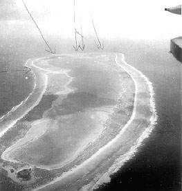
The detail at left is taken from an aerial photo shot from a much greater altitude (8,000 ft.) on April 30, 1939. It shows wide footpaths associated with the newly established village. Note that they start from a central location inland and fan out toward different places along the shoreline. The photo below was taken from the starboard cockpit window of a Supermarine Walrus launched from HMS Leander on December 1, 1938 (the starboard wingtip with navigation light and the tip of the starboard wing float with mooring ring are visible at upper right). The hand-drawn arrows indicate features of interest at the far end of the island — the shipwreck, the main lagoon passage, etc.
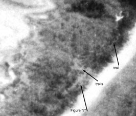
The picture below is a detail from the photo at right which has been enhanced by Photek, Inc. of Hood River, Oregon. Note the naturally occurring open avenues of coral rubble which form a figure “7.” That feature is still present today. (The color photo above was taken in 1996 looking seaward along the “top” of the 7.)
Of particular interest is what appears to be a network of trails or footpaths associated with the top of the 7 and a single winding path leading to a large white open area farther up the shoreline. Although vaguely airplane shaped, detailed inspection reveals that the white feature is not an airplane. It seems to be just a T-shaped sandy area.
 |
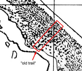 |
It is worth noting that we are not the first to notice “trails” on this part of the island. When the U.S. Navy prepared a map of Gardner Island from the aerial photo mosaic taken on April 30, 1939 and the results of the surface survey made by USS Bushnell in November 1939, the map maker noted the presence of an "old trail" between the lagoon and the ocean at a location about one kilometer northwest of the “7.” The feature can be seen in the 1939 aerial mosaic and in the 1938 photo.
It is, of course, possible that the features which resemble trails are some naturally occurring phenomenon that we do not at present understand, but if they are evidence of human activity the implication is that someone was active on a remote section of the isalnd in the years immediately prior to 1938. Exactly why that particular part of the atoll might be attractive to a castaway is hard to say. It was, and is, dominated by a forest of tall, shady Buka trees (Pisonia grandis) which are home to a rich assortment of sea birds. The ocean shore near the “7” is unusually free of the dense protective wall of underbrush that characterizes most of the coastline and so might provide a good view of the northern horizon for someone hoping for rescue. The area is far from the only stands of coconut palms that were present on the island in those pre-settlement years but the drought conditions which prevailed throughout much of 1938 may have rendered those trees useless as a source of sustenance.
In any event, this part of the atoll clearly merits further attention.
