 |
10/15/99
|
|
| Earhart Project Research Bulletin #16 10/15/99 |
|
| Forensic Imaging Project | |
| The historical photographs shown below are being examined by Photek, Inc.
of Hood River, Oregon in an attempt to determine whether the objects visible
on the reef in the early photos are, in fact, airplane wreckage as reported
by former residents of Nikumaroro (see the preceding Research Bulletin “The
Carpenter’s Daughter”). If the reports can be affirmed with photographic
evidence, the implications for the Earhart investigation can hardly be overstated.
Earhart’s Electra is the ONLY aircraft missing in the Central Pacific prior
to World War Two.
In each case it is essential that we acquire the most original version of the photograph available for Photek to work with. We’ll update this bulletin periodically to report on our progress. |
Photo #1
Status: Photek now has the negative of the copy photo we made in 1991 from Mr. Bevington’s original print (the original negative has been lost). The original print has since been given, with the rest of Mr. Bevington’s collection, to the Rhodes Library at Oxford University. We have, with Mr. Bevington’s agreement, asked that the original print be loaned to TIGHAR. We're waiting for an answer. |
Photo #2 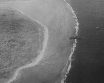 This photo was taken in December 1938 by a Supermarine Walrus aircraft launched
from the cruiser HMS Leander as part of the New Zealand Pacific Aviation
Survey Expedition’s visit to Gardner Island. The expedition’s small chartered
ship Yanawai can be seen offshore near the wreck of the S.S. Norwich
City. The material visible in Photo #1 is not apparent in this photo
but the tide is high and the wreckage was said to visible only at low tide.
There are techniques for looking below the surface of shallow water which
Photek will be using on this photograph to see if anything is there.
This photo was taken in December 1938 by a Supermarine Walrus aircraft launched
from the cruiser HMS Leander as part of the New Zealand Pacific Aviation
Survey Expedition’s visit to Gardner Island. The expedition’s small chartered
ship Yanawai can be seen offshore near the wreck of the S.S. Norwich
City. The material visible in Photo #1 is not apparent in this photo
but the tide is high and the wreckage was said to visible only at low tide.
There are techniques for looking below the surface of shallow water which
Photek will be using on this photograph to see if anything is there.
Status: Photek has a copy negative we had acquired earlier from the New Zealand Archive. |
Photo #3
Status: We have requested a copy negative of this photo from the New Zealand Archive. |
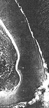
Photo #4 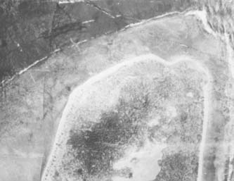 This is part of an aerial mosaic of the island that was made by a U.S. Navy
floatplane (probably a Grumman J2F Duck) launched from the seaplane tender
USS Pelican on April 30, 1939. The resolution in the photo is not
great but at least it’s a direct overhead view of the area in question.
This is part of an aerial mosaic of the island that was made by a U.S. Navy
floatplane (probably a Grumman J2F Duck) launched from the seaplane tender
USS Pelican on April 30, 1939. The resolution in the photo is not
great but at least it’s a direct overhead view of the area in question.
Status: Photek has a copy neg made for us by the U.S. National Archives. |
Photo #5
Status: With a better copy of the photo Photek may be able to tell for sure what the airplane shaped object on the reef is. We have requested a copy negative from the New Zealand Archive. |
Photo #6
Status: We have requested a copy negative from the New Zealand Archive. |
Photo #7
Status: A TIGHAR volunteer recently took a copy photo of this image which is in the USAF Historical Center collection at Maxwell AFB, Alabama. We have forwarded it on to Photek. |
Photo #8
Status: We have a print made from the original negative which we have sent to Photek. |
Photo #9
Status: We now only have this photo as a photocopy. We have requested a copy negative from the New Zealand Archive. |
Photo#10
Status: We now only have this photo as a photocopy. We have requested a copy negative from the New Zealand Archive.
This Forensic Imaging Project will cost TIGHAR about $7,000. If you’d like to contribute with a donation of $100 or more we’ll send you an 8 x 10 print of the most revealing image the project produces (whatever that may prove to be). For a contribution of $200 or more we’ll provide internet access to high resolution scans of all ten of the images shown above as they become available so that you can do your own analysis. If you’re interested in contributing just drop us an email. |
|
||||||||||
|
 This
photo was taken by British Colonial Service Cadet Officer Eric Bevington
in October 1937. It appears to show debris of some kind on the reef in
the same location where former island resident Emily Sikuli described
wreckage which she was told was from an airplane.
This
photo was taken by British Colonial Service Cadet Officer Eric Bevington
in October 1937. It appears to show debris of some kind on the reef in
the same location where former island resident Emily Sikuli described
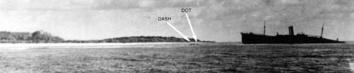
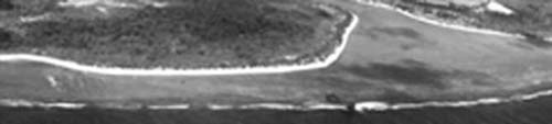
wreckage which she was told was from an airplane.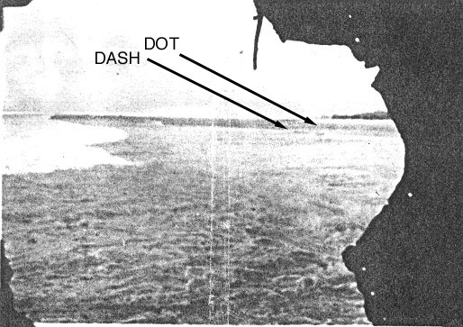 This is a snapshot taken by the New Zealand survey party sometime
between December 1, 1938 and February 5, 1939. All we have at this time is
a photocopy of the original print which is in a scrapbook of photos in New
Zealand. Even so, this photo, taken looking north out through a hole in the
hull of the Norwich City, seems to show the same two objects that
appear in the 1937 Bevington photo (Photo #1). This could be a very important
photo.
This is a snapshot taken by the New Zealand survey party sometime
between December 1, 1938 and February 5, 1939. All we have at this time is
a photocopy of the original print which is in a scrapbook of photos in New
Zealand. Even so, this photo, taken looking north out through a hole in the
hull of the Norwich City, seems to show the same two objects that
appear in the 1937 Bevington photo (Photo #1). This could be a very important
photo. This photo was taken in June 1941 when at least four US Navy PBYs visited
Gardner and took various photos. This is a detail from a shot that shows
the village and the western shoreline of the island. As is apparent from
comparison to earlier photos, storm activity has broken off the stern of
the S.S. Norwich City and debris has been scattered shoreward over
the reef. At first we were shocked to see what looks like an intact airplane
on the reef just beyond the shipwreck and, after thinking about it, we suspect
that’s exactly what it is. We think that it’s one of the other PBYs making
a low pass over the shipwreck. There’s nothing obvious in the spot where
debris appears in the earlier photos but, in the wake of the sort of event
that would cause the sort of damage we see to the shipwreck, that is hardly
surprising.
This photo was taken in June 1941 when at least four US Navy PBYs visited
Gardner and took various photos. This is a detail from a shot that shows
the village and the western shoreline of the island. As is apparent from
comparison to earlier photos, storm activity has broken off the stern of
the S.S. Norwich City and debris has been scattered shoreward over
the reef. At first we were shocked to see what looks like an intact airplane
on the reef just beyond the shipwreck and, after thinking about it, we suspect
that’s exactly what it is. We think that it’s one of the other PBYs making
a low pass over the shipwreck. There’s nothing obvious in the spot where
debris appears in the earlier photos but, in the wake of the sort of event
that would cause the sort of damage we see to the shipwreck, that is hardly
surprising. 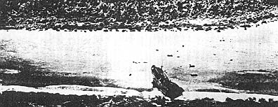 This is another photo taken from a U.S. Navy PBY in June 1941. All we have
is a photocopy but it’s an almost perfect view of the area we’re interested
in.
This is another photo taken from a U.S. Navy PBY in June 1941. All we have
is a photocopy but it’s an almost perfect view of the area we’re interested
in. 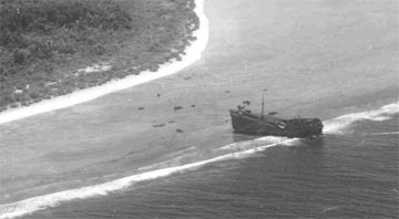 This is a U.S. Army Air Corps photo taken in January 1942. It’s another
excellent view of the area in question and should help us track the distribution
of wreckage and perhaps figure out where we should be looking for the material
that was on the reef before the storm.
This is a U.S. Army Air Corps photo taken in January 1942. It’s another
excellent view of the area in question and should help us track the distribution
of wreckage and perhaps figure out where we should be looking for the material
that was on the reef before the storm.
 This photo was taken from a U.S. Coast Guard PBY in 1943 or 1944 and should
be helpful in tracking the wreckage distribution pattern.
This photo was taken from a U.S. Coast Guard PBY in 1943 or 1944 and should
be helpful in tracking the wreckage distribution pattern. 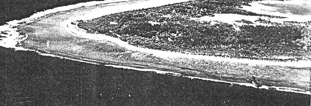 This photo was taken in May 1953 as apart of a mapping survey of the island and
should be helpful in tracking the wreckage distribution pattern.
This photo was taken in May 1953 as apart of a mapping survey of the island and
should be helpful in tracking the wreckage distribution pattern.
 This
photo is also from the May 1953 mapping survey and should be useful for comparison
to the 1939 overhead photo (Photo #4)
This
photo is also from the May 1953 mapping survey and should be useful for comparison
to the 1939 overhead photo (Photo #4)