
That phrase, heard at 08:43 a.m., was part of the final inflight radio transmission received by the Coast Guard cutter Itasca. It was the only meaningful position report received from Amelia Earhart on the morning of July 2, 1937. In it is contained a wealth of information about what she and her navigator knew – and what they didn’t know – about where they were, what they had done to get there, and what options were available to them to try to save their airplane and their lives. Understanding those few words is essential to solving the riddle of their disappearance.
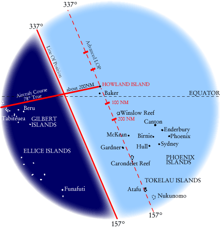
The numbers refer to degrees on a compass. Amelia was saying that they were on a line that points 157 degrees (roughly southeast) one way, and 337 degrees (roughly northwest) the other way.
Of course, you are on a 157 337 line right now and it can’t tell you anything about where you are, but Amelia did not say “We are on a line ....” She said, “We are on the line ...” because, on the morning on July 2, 1937 in the Central Pacific “the line 157 337” had special significance.
We all know that the sun rises in the east and that the dawn, the line between night and day, marches westward at a steady, predictable pace. It stands to reason then, that if you knew when (using Greenwich Mean Time) the sun was going to appear in London, New York, and Los Angeles, you could tell which city you were in just by noting what time the sun came up – couldn’t you? Well, no, not really. You might be in London, England but you could also be in Edinburgh, Scotland or Paris, France or anywhere along that line where the sun comes up at that same time; but at least you’d be quite sure that you were not in New York or L.A.

That dawn line is an example of what is known to navigators as a Line of Position (LOP). In fact, an LOP can be derived from any heavenly body. All you need is a way to measure how high in the sky an object is (that’s what a sextant does), and a book of tables (known as an almanac) to tell you exactly when things are supposed to be where. At night you can “shoot” several stars and get several Lines of Position. Where they cross is where you are. Bingo – you’re a celestial navigator. Now let’s go back to the morning of July 2, 1937 in the Central Pacific.
We lied about the sun coming up in the east. It doesn’t – not exactly anyway. It actually comes up in a slightly different direction every day, and it climbs at an angle so the direction is constantly shifting, but the good news is that it’s all predictable. That morning it came up at 67 degrees, and because a Line of Position is always at a right angle to the observed celestial body, the line to be derived from the rising sun was – you guessed it – 157/337. By noting the time that the sun came up, Amelia’s navigator, Fred Noonan, could draw a 157/337 line on his map and know that they were somewhere on that line.
But wait a minute. Amelia’s “We are on the line 157 337...” message was received about two and a half hours after sunrise at Howland Island. If Earhart’s statement was based upon Noonan “shooting” the sun at that time, the line would have been more like 150/330. What’s going on?It’s really not at all mysterious. Noonan was employing a textbook procedure for finding an island using a single Line of Position. Here’s how it works.
First of all, it’s important to remember that Noonan knew that the rising sun would give them a 157/337 line. He had that information back in Lae, New Guinea as soon as he knew what day they were going to be making the flight. The only question was how far along they would be when the sun came up, and he wouldn’t know that until he saw the sun and noted the time. Then he could draw his 157 337 line on his map and say, “Okay, we’re somewhere on this line.” All he had to do then was to draw another 157/337 line that passed through Howland Island and measure the distance between the two parallel lines. With a good idea of how fast they were going it was a simple matter to predict at what time they would reach the ”advanced” LOP.
Of course, knowing where they were in an east/west sense was not good enough. To find tiny Howland Island it was essential that they know if they were north of, south of, or right on, course. That’s what Radio Direction Finding was supposed to do. Noonan’s job was to get them close – within, say, a couple hundred miles – and it was Amelia’s job to use the radio to fine tune the final approach. That’s where things went haywire.
At 06:15 a.m. Earhart said that she was about 200 miles out and asked the Itasca to take a bearing on her signal. No reply. She tried again half an hour later at 06:45. Still no response to her call. Unbenownst to her, the Itasca was hearing her just fine but they were unable to get a bearing on her and she was not receiving their replies.
An hour later, at 07:42, Earhart transmitted, “We must be on you, but cannot see you – but gas is running low. Have been unable to reach you by radio. We are flying at 1,000 feet.”
Had she been talking on the telephone instead of a radio she might have said, “Fred’s watch says that we have reached the advanced LOP but we can’t see the island. We must be either too far north or too far south, but now we’re starting to burn into our four hour fuel reserve. We know that you are somewhere on this 157/337 line but we have been unable to reach you by radio so we have not been able to get a bearing and we don’t know which direction to turn. We’ve descended down to 1,000 feet to get below this scattered deck of clouds so we can look for the island.” Still she heard nothing in reply.
Fifteen minutes later she decided to try something different. Instead of asking the Itasca to take a bearing on her signals, she would try to take a bearing on theirs using her own Radio Direction Finder – if she could just hear something. At 07:58 she said, “We are listening but cannot hear you. Go ahead on 7500 with a long count, either now or on the scheduled time on half hour.” (Amelia was using Greenwich Time so, for her, it was 19:28.)
Itasca did not have the capability of sending a voice message (“a long count”) on 7500 kilocycles but they immediately sent a series of Morse code letter “A”s – dit, dah; dit, dah; dit, dah.
For the first time, Earhart’s headphones delivered something more than static. The letter A was the prearranged signature for code signals from the Itasca and she must have been thrilled to have confirmation that they were at least within radio range of their destination. However, any elation she felt was short-lived because it quickly became apparent her Direction Finder would not give her the direction from which the received signals were coming.
At 08:00 she said, “We received your signals but unable to get a minimum. Please take a bearing on us and answer on 3105 with voice.” Then she sends long dashes on 3105. She has given up trying take a bearing on the Itasca and has gone back to trying to get them to take a bearing on her – but it’s just not working. Itasca replies that they can’t take a bearing on such a high frequency but, of course, AE hears nothing.
So here she is, on the advanced LOP. She knows that Howland Island is somewhere on this 157/337 line, close enough for the Itasca to hear her radio calls, but that could be several hundred miles. What to do now? Turn left? Turn right? By happy coincidence, Howland is not the only island on the 157/337 line. Although there is no land to the northwest of Howland for thousands of miles, just forty miles to the southeast is Baker Island, another U.S. possession and, like Howland, occupied by Department of the Interior “colonists.” About 350 nautical miles down the line is Gardner Island, a British possession. And far, far down the line – over 600 nautical miles – is Atafu, also known as Duke of York Island. Of course, the island they want to reach, and hope to reach, is Howland – the only place in the entire Central Pacific where there is an airfield – but the fate to be avoided at all costs is running out of gas over the open ocean. The most reasonable course of action is obvious: fly northwestward (337°) along the line for a short way to see if Howland is nearby in that direction. If it is not, turn around and proceed southeastward (157°) until you come to an island. If you’re lucky it will be Howland. If it’s Baker you’ll know where you are and still have enough fuel to reverse course again and fly to Howland. If it’s Gardner, chances are that you won’t have enough fuel to double back all the way to Howland, but at least you won’t go in the drink and you may even be able to land safely, figure out what’s wrong with the radio and call for help. If it’s Atafu, it means that you hit the advanced LOP much further south of course than you thought, but it’s still land.
It is important to understand that a decision to fly southeastward on the advanced LOP was not a decision to abandon hope of reaching Howland and proceed to an alternate destination. On the contrary, it was the only available course of action for trying to find Howland that also virtually guaranteed a landfall of some kind even if it wasn’t Howland. In that context, Earhart final inflight radio message heard by the Itasca at 08:43 makes sense:
“We are on the line 157 337. We will repeat this message. We will repeat this on 6210 kilocycles. Wait.”
This, like her previous transmissions, was heard on 3105 kilocycles. Having had no luck hearing replies to those transmissions she was going to try her other frequency. But after a moment, suddenly, unexpectedly, and contrary to what she just said, she was back on 3105 saying something that was logged as a “questionable” transmission:
“We are running on line north and south.”
Nothing further was heard on 6210 or 3105. Some believe that the silence meant that the aircraft ran out of fuel at that moment, giving Earhart not even enough time to send a distress call. TIGHAR notes, however, that the aircraft should have had several hours of fuel remaining, that the message came at Earhart’s regularly scheduled transmission time, and that the known vagaries of radio frequencies may easily explain why no further transmissions were heard.
In the last inflight transmission heard by the Itasca, Earhart gave the only position information she had, “We are on the line 157 337” and described the only reasonable course open to them under the circumstances: “We are running on line...” Perhaps she said “We are running on line north and south.” Or maybe it was “We are running on line north to south.” Or maybe it was “We are running on line north then south.” The Itasca radio operator wasn’t sure and we’ll never know exactly what she said, but there is no mystery about what line she was talking about and its significance to any investigation of her disappearance.
*The Itasca log says “We are circling…” but the word “circling” is typed over the partially erased word “drifting.” Clearly the operator was not sure what the word was. “Listening” is the word that makes the most sense in the context of the situation. See complete discussion of this point at Going in Circles and Log Jam. Back to text.
