 |
|
|
|
|
|
|
|
|
|
|
|
||
|
|
|
||
pp. 5 – 11
The expedition’s first mission was to determine whether the anecdotal accounts gathered in Funafuti at the end of Niku III in 1997 might lead directly to discovery of the main body of wreckage and, thus, permit the Niku IIII expedition to be organized as an archaeological recovery operation. Recognizing that the identification of conclusive Earhart wreckage would, by definition, put those artifacts at risk, this purpose of the expedition was not widely publicized. No such wreckage was found on this trip, so the point is now moot. The secondary mission of the expedition was as a preparatory operation to gather information for Niku IIII, an intensive search operation now scheduled for 2001. The specific objectives of the expedition were:
- Test the hypothesis that airplane parts could be found in the dense beachfront vegetation of Nutiran district near a “European-style house,” per an anecdotal account by Tapania Taiki who was interviewed by TIGHAR on Funafuti in 1997 (see TIGHAR Tracks Vol. 13, No.1: “I saw pieces of an airplane...”). Ms. Taiki lived on Nikumaroro as a young teenager with her family in the late 1950s/early 1960s just before the settlement was abandoned.
- Conduct a reconnaissance of the beachfront areas on the lagoon shore where Pulekai Songivalu, interviewed by TIGHAR on Funafuti in 1997, said he saw airplane wreckage when he served as the island’s schoolmaster during the late 1950s/early 1960s. Mr. Songivalu is Ms. Taiki’s father.
- Conduct a reconnaissance of Kanawa Point, one of three geographical locations identified by TIGHAR researchers as possibly fitting the description of where a castaway’s remains and campsite were discovered by Gerald B. Gallagher, Officer-in-Charge, Phoenix Islands Settlement Scheme, in September 1940.
- Familiarize the project’s forensic anthropologist, Dr. Karen Ramey Burns, with the site where shoe parts were found during Niku II in 1991 (known as the “Aukeraime Site”) and conduct a further investigation of the site with the aid of remote-sensing data gathered during Niku III in 1997. The Aukeraime Site is the second candidate for where the bones were found in 1940.
- Familiarize Dr. Burns with the site near the southeast end of the island where village-related artifacts were found during Niku IIIP in 1996. This is the third location suspected of being where Gallagher’s discovery took place.
| The team assembled to conduct these operations consisted of: | ||
| Richard Gillespie | TIGHAR Executive Director | Project Director |
| Karen Ramey Burns, PhD | TIGHAR #2071E | Forensic anthropologist |
| John Clauss | TIGHAR #0142CE | Veteran of Niku I, II, IIIP, III, and the Kanton Mission |
| Veryl Fenlason | TIGHAR #0053CE | Veteran of Niku I, II, IIIP, and III |
| Richard “Skeet” Gifford | TIGHAR #0001CEB |
Member of TIGHAR’s Board of Directors and project sponsor |
| Van Hunn | TIGHAR #1459CE | Veteran of Niku III |
| Jerry Ann Jurenka | TIGHAR #0772E | TIGHAR member and project sponsor |
| Chris Kennedy | TIGHAR #2068E | TIGHAR member and project sponsor |
| Russ Matthews | TIGHAR #0509CE | Veteran of Niku I, II, IIIP, and the Kanton Mission |
| Gary Quigg | TIGHAR #1025CE | Veteran of Niku III |
| Richard Reynolds | TIGHAR #0981CEB | Member of TIGHAR’s Board of Directors, veteran of the Kanton Mission, and project sponsor |
| Ronald Rich | TIGHAR #2267E | TIGHAR member and project sponsor |
| Accompanying the expedition as an official representative of the Republic of Kiribati was Senior Examining Officer, Kiribati Customs, Manikaa Teuatabo. Mr. Teuatabo also accompanied the Niku II and Niku IIIP expeditions. | ||
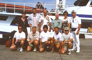 |
Standing, from left: Kar Burns, Russ Matthews, Ron Rich, Skeet Gifford, Jerry Jurenka, Veryl Fenlason. Kneeling: Gary Quigg, Ric Gillespie, Chris Kennedy, John Clauss, Van Hunn Not pictured: Dick Reynolds, Manikaa Teuatabo. TIGHAR Photo. |
|
| The direct cost to TIGHAR for the Niku IIIIP expedition was: | |
|
$5,785 |
|
$99,492 |
|
$1,904 |
|
$2,500 |
Total |
$109,681 |
|
*several
team members paid their own airfare |
|
| The cost of the Fiji Bone Search was: | |
Airfare* |
$1,982 |
Accommodations |
$1,300 |
Meals and incidentals |
$2,849 |
Car rental |
$1,351 |
Total |
$7,482 |
|
*one
team member paid her own airfare |
|
| In addition to these direct expenses, TIGHAR’s operating expenses during the period of preparation and execution of the expeditions (February through July, 1999) were roughly $90,000. | |
|
Grand
Total –- $207,523 |
|
July 1-3
Team flies to Fiji and boards expedition vessel Nai’a at port of Lautoka. One large bag of expedition gear (with essentials such as metal detectors and laptop computer) is missing and it takes two days to track it down and get it to Fiji. When the bag finally arrives the screen of the laptop has been cracked in transit, but the computer is still usable.
July 5
Nai’a departs Fiji. Once clear of Fijian waters, seas become quite high (approximately seven meters) with head winds and conficting currents slowing progress at times to a little as 6 knots. Structural problems with the mast prevent the use of the sail with consequent loss of its stabilizing and fuel saving effect.
Nai’a sets course for Fiji. Photo courtesy J. Clauss.
July 6–10
Continued high seas make for an unpleasant passage. No one can go out on the exposed decks, the galley is limited in what foods can be prepared and served, spills and breakage are commonplace, and just moving about requires constant vigilance. Most of the team is seasick to at least some degree and a few are truly miserable.
A rough ride to Niku brought back memories of the storms of 1997. Photo courtesy J. Clauss.
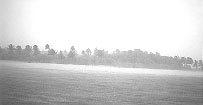
July 11
Heavy rain squalls and a wet welcome back to Nikumaroro. Photo courtesy J. Clauss.Having arrived at Nikumaroro just before dark the previous evening, the team goes ashore at 07:45 and spends the day surveying and building a trail from the landing to the shore of the lagoon passage where a skiff, walked in over the reef at high tide, will be based to ferry the team over to Nutiran. Seas in the lee of the island are relatively calm – a welcome relief. However, tropical downpours during the day make the heavy work of clearing the trail through the jungle a soggy endeavor. It is also discovered that the ship’s water maker, which had been unusable during the voyage out due to the extreme rolling, is not working. Without the ability to make fresh water the expedition must depend entirely upon the tanks of water aboard the ship. This supply should be adequate if carefully conserved, but luxuries such as laundry are out of the question.
July 12
In the morning a base camp is established on the Nutiran shore and base lines are “shot in” with the pulse laser from known features on the village shore to permit accurate mapping of the search area. More heavy rain slows the work. In the afternoon, the team begins the process of setting out grid lines 20 meters square in the sector where aerial photography indicates there was once a structure which may be the “European style house.” Nearby, the 1953 photo also shows a cruciform feature in the beachfront vegetation which looks alarmingly similar to an aircraft. Hopes are high for a significant discovery but the day’s searching yields no sign of a European style house (a structure built of wood frame and boards rather than local materials), let alone an airplane. A grave about four feet in length is found not far from the beachfront. Like the grave excavated on Aukeraime in 1991 and found to be that of an infant, this burial seems to be anomalous in the context of the island settlement and fits folklore about bones said to have been found and buried on Nutiran by the early settlers.
July 13
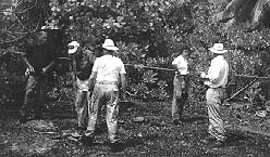 Looking for the “European style house.” L to R, Ron Rich, Veryl Fenlason, Van Hunn, Jerry Ann Jurenka, Ric Gillespie. Photo courtesy J. Clauss.
Further gridding and searching reveal a scattering of cultural material (nails, wire, cans, etc.) indicating that a structure of some kind once stood on the spot where the putative European style house is seen in the 1953 aerial photo, but the absence of boards or framing suggests that the structure was made from local materials. An area around the grave is cleared and, after consultation with Dr. Burns, the decision is made to seek permission from the Kiribati representative to excavate the grave.
July 14
After a discussion at the grave site with Senior Examining Officer Manikaa Teuatabo, permission to excavate is granted and digging begins. Meanwhile, a detailed search of the area where the cruciform object appears in the photo finds only vegetation and what may be a broken oarlock – possibly from one of the lifeboats from the SS Norwich City. Two divers, Van Hunn and Jerry Jurenka, inspect the lagoon passage and inshore reef area at high tide for any anomalous material. The results are negative. Search operations are extended northward along the Nutiran shore in the hope of finding something that better fits the description of a European style house.
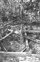
Late in the day, Chris Kennedy comes upon boards and sheets of corrugated metal. Further investigation reveals the ruins of a structure incorporating wood framing and boards. There are pipes, a faucet, and even a shower head. It seems quite likely that this was a European style house but it does not seem to be present in the 1953 aerial photos. Plantings of coconut and pandanus just inland from this location support the possibility that this structure is a relic of development in the later days of the settlement. That would conform to Ms. Taiki’s time on the island in the late 1950s. Among the debris where the house once stood is a small (1.5 inch by 5 inch) piece of aluminum aircraft skin which had been cut through rivet holes along one long edge. The presence of zinc chromate corrosion inhibitor would appear to disqualify it as being from Earhart’s aircraft.
July 15
On doctor’s orders, one team member with a foot infection remains aboard ship and is on antibiotics. Ashore, while Dr. Burns and two assistants, Quigg and Gifford, proceed with the grave excavation, the rest of the team begins to lay out grids and search the area southward from the newly identified European house. Heavy iron debris from the shipwreck is found as much as ten meters back into the beachfront vegetation along the shoreline directly in front of and southward from the Norwich City, but no aluminum or aircraft-related material is in evidence. Because it will be roughly the half-way point in the expedition, the following day is declared a “day off” for anyone who needs to take a break. Aboard ship, the water maker is still not working.
July 16
On this “day off” the entire team turns out for duty except for two people with minor injuries. Further gridding and searching southward from the European house fail to turn up anything of interest. Dr. Burns’ team reaches the interment in the grave and finds the bones of a two or three year old child. As previously agreed, as soon as the grave is established to be unrelated to the Earhart mystery, further excavation ceases and the grave is later restored to its original condition and appearance.
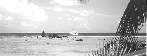
At 13:00 a satellite telephone communication with TIGHAR’s office in Delaware brings the news that Dr. Tom King in Fiji has interviewed a former resident of Nikumaroro who reports having seen aircraft wreckage (heavy structures, not aluminum sheet) on the reef north of the Norwich City shipwreck in the years prior to WWII (1939-1941). Reports dating from the late 1950s had placed scattered aircraft wreckage on the reef and along the shoreline south of the shipwreck. This new information matchs our previously formulated hypothesis that the landing had been made on the reef and the airplane destroyed by surf action, but indicates a more northerly specific location than we had previously contemplated.
The remains of the 1929 shipwreck. New information alleges that aircraft debris was once located just north (to the right in this photo) of the wreck. Photo courtesy V. Fenlason.Later in the afternoon Gillespie and Clauss conduct a reconnaissance of the lagoon shore in the area where Mr. Songivalu reported seeing airplane wreckage. While access to the area by skiff is not as difficult as had been anticipated, the beachfront vegetation is quite heavy in most areas until a low ridge of land about 50 meters inland from the lagoon shore marks the beginning of open Buka (Pisonia grandis) forest. A variety of lightweight flotsam (plastic, styrofoam, etc.) indicates that this first 50 meters of shoreline is occasionally subject to flooding, but conducting a thorough search of the entire shoreline by visual means would be labor intensive and time consuming.
July 17
Temperatures hover near 100 degrees Fahrenheit as they have since the team’s arrival on the island. Shifting the Nutiran shoreline search northward based on the new information, the team begins inspecting the dense beachfront scaevola from the point of land just off the bow of the Norwich City wreck and working northward. In an attempt to inspect open areas inland, Gillespie leads several team members into vegetation so thick that it takes hours to cut their way out and resume an organized search. The methodology developed for searching what can only be described as the beachfront scaevola wall is for transects to be cut into the bush on a heading 90 degrees to the shoreline and flagged with colored tape. The flagged transects are spaced 25 meters apart and go back into the scaevola far enough to be well beyond any evidence of washed up material (typically 30 or 40 meters). Searchers then space themselves along the beach closely enough to be sure they can visually cover the area between themselves and their colleagues on either side – and start cutting their way in, staying on line as much as possible, much like the beaters in an old-fashioned tiger hunt. When the line reaches the end of the flagged transects the searchers make their way back to beach, move down to the next block, and start all over again.
Veryl Fenlason and John Clauss shoot in a line in dense scaevola. Photo courtesy Richard Gifford.
Yet another grave is identified on the point just off the bow of Norwich City but excavation is not an option due to lack of remaining time. In the afternoon, at low tide, an inspection of the reef north of Norwich City permits a preliminary evaluation of areas that appear flat and smooth enough to permit a Lockheed 10 to land intact. That evening aboard Nai’a the water maker is still not working despite heroic attempts at repair by the ship’s crew. Team members accomplish some semblance of laundry by showering fully clothed. Quasi-clean clothes are then dried overnight in the ship’s drier.
July 18
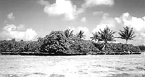
In the morning, while most of the team continues to work northward along the Nutiran shore, cutting 40 meter transects back into the bush at five to ten meter intervals, Gillespie, Matthews, Clauss and Burns conduct a reconnaissance of Kanawa Point. The cove just east of the Point is found to be very deep in soft silt, making the landing of a skiff difficult (and dangerous if you don’t realize that what looks like a sandy bottom is, in effect, quicksand. Hop out of the boat to push it ashore and – gloop – you’re gone). Kanawa Point, while probably originally quite open and pleasant when shaded by Kanawa trees, is now so covered in dense scaevola as to be impossible to search visually from any practical standpoint. On the lagoon shore across the cove to the east of Kanawa Point, a feature first noted by Tom King in 1989 was noted. The coral shelf above the water line is strewn with the shells of an estimated 300 giant clams over an area easily 20 meters long by perhaps 5 meters wide. In some cases the shells have been there so long as to be cemented into the coral and, in at least one spot, a number of shells are neatly stacked, back to front. There is no doubt that this is where a human or humans harvested, opened, and possibly ate clams. A few clams still grow in the surrounding shallow water. A scattering of shells was also found on the shore of Kanawa Point itself.
 |
| Kanawa
Point. Photo courtesy J. Clauss.
|
The Aukeraime Site was also visited briefly. There has been a significant increase in lagoon shore scaevola growth since TIGHAR’s last visit in 1997. A metal detector inspection of a spot where remote-sensing data gathered in 1997 suggested there might be metal in the ground was negative. With time short, a decision was made to forego a visit to the southeast corner of the island.
In the afternoon, at low tide, further inspections and measurements were taken on the reef flat north of Norwich City and the pulse laser was employed to measure the length of areas that were smooth enough to permit a safe landing. The longest area measured was 213 meters (700 feet). It has been estimated that Earhart’s aircraft, at near empty weight and landing into a 10 to 15 knot wind as is common on the reef flat, could come to a stop in as little as 91 meters (300 feet).
With one more full day of work remaining before the ship must depart for Fiji, the water maker is finally working.
July 19
Inspection of the heavy beachfront vegetation north of Norwich City continues. In addition to the search conducted at the southern tip of Nutiran in the area around the initially supposed “European style house” and the gridding and searching done near the ruin that does seem to fit that description, the entire length of the Nutiran beachfront from the north point southward to the west point just below the shipwreck, a distance of some 700 meters (nearly half a mile) has been searched visually to a depth into the vegetation of 30 to 40 meters The search turns up no aircraft-related debris. Norwich City debris is present on the reef and in the first few meters of beachfront vegetation from a point perhaps 50 meters north of the bow to at least 500 meters southwestward down the beach. The reef and shoreline north of the wreck are free of any type of cultural debris other than flotsam and these occur primarily on the open beach and in the first 20 meters of vegetation. After nine solid days of heavy physical labor in the intense heat, many team members are becoming dangerously exhausted.
Ready to leave. L to R, Dick Reynolds, Jerry Ann Jurenka, Chris Kennedy, Ric Gillespie,
Russ Matthews, Veryl Fenlason, Gary Quigg, and Van Hunn. Photo courtesy J. Clauss.
July 20
Departure day. The skiff must be brought out of the lagoon by noon at high tide and the morning is spent finishing up some last minute searching, breaking camp and recovering all of the equipment back across the lagoon passage. By 14:00, everything and everyone is off the island and that evening Nai’a sets a course for Fiji.
July 21–25
As if to make up for the rough outward passage, the trip back to Fiji is smooth and fast, arriving in the port of Suva a full day ahead of schedule. This permits us to terminate the charter a day early and thus save nearly $5,000.
Back to Archive List
