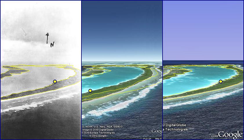
...If anyone knows how to adjust the default focal length that Google Earth uses...my best guess of the altitude that Lambrecht was flying was 1000 ft +- 300....
Mark/Bill
Lining up photos like this is a very tricky business!
In this particular case, focal length is not as important as is the azimuth or axis along which the photo was taken (or LOP so to speak

). We also don't know if any enlarging or cropping was done during the photo developing process, making it even more difficult.
We are dealing with an object that is in a 2 dimensional plane. Since Nikumaroro island is at sea level and relatively no elevation, it makes it very difficult to line it up in a 3-D world, not to mention anomalies that can occur with digital imaging and aspect ratios once a photo has been 'computerized'.
The best we can do at this point is to find the axis upon which the photo was taken. From there we can make an educated guess where and how high the photo was taken.
In the image below you can see the original shoreline in yellow draped onto google earth, along with a yellow dot with representing a real-world position on the ground. You'll notice how the shoreline does not match exactly and the yellow dot is not framed correctly. In the third image, if we rotate google earth onto the axis in which the photo was taken, we now see that the shoreline and dot line up much better.
To create this yourself in google earth using the Snapshot View -> Properties. Enter these coordinates to get a representation of what the axis looks like from a birds-eye.
Latitude: 4°40'59.90"S
Longitude: 174°30'37.98"W
Range: 3339m
Heading: -67.000000°
Tilt: 86.000000°
Click
HERE for full size image.


 Author
Topic: FAQ: Colorado / Lambrecht Search, 9 July 1937 (Read 567666 times)