|
by Thomas F. King, Ph.D.
|
|
| McKean Island | |
|
by Thomas F. King, Ph.D. |
|
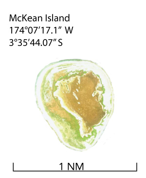 McKean
Island is a raised coral island – in essence, a once-living
coral reef that has been elevated above sea level by tectonic forces.
It is roughly circular, about 3/4 mile across, surrounded by a fringing
reef. Its maximum elevation above sea level is about five meters. J.D.
Hague, who devoted most of a paragraph to its description in 1862, suggests
that it at one time had a lagoon1, but uplift
apparently raised it to a point at which it had become a soggy depression
in which bird guano accumulated, and had for thousands of years. McKean
Island is a raised coral island – in essence, a once-living
coral reef that has been elevated above sea level by tectonic forces.
It is roughly circular, about 3/4 mile across, surrounded by a fringing
reef. Its maximum elevation above sea level is about five meters. J.D.
Hague, who devoted most of a paragraph to its description in 1862, suggests
that it at one time had a lagoon1, but uplift
apparently raised it to a point at which it had become a soggy depression
in which bird guano accumulated, and had for thousands of years.
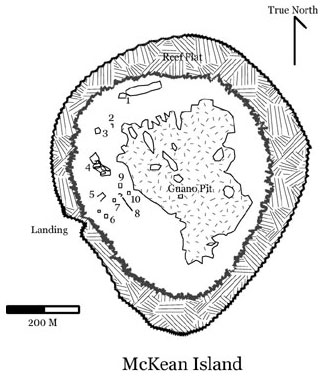
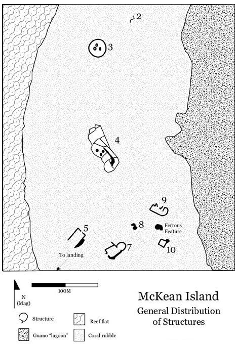
McKean has been an officially declared bird sanctuary since 1938,2 and today is protected as such under Kiribati law. The island is virtually devoid of vegetation; thin colonies of purslane (Sesuvium sp.) and other low, shrubby plants grow in low-lying areas where a thin soil has formed. The island is home to tens of thousands of sea birds, including terns (Gygis sp.), frigate birds (Frigata sp.), and gulls (Larus sp.). Approaching McKean by ship, one can hear its birds before the island itself comes into view, and if one is downwind one can smell them. The north and east sides of the island exhibit pronounced storm surge ridges, with a linear depression behind them. Along the north shore this depression is two to three meters deep and about ten meters wide, making it, after the guano “lagoon,” the island’s most prominent geographic feature. “Discovered” by American whalers by the late 1820s,3 McKean was given its name (after the crewmember who first sighted it) by Commander Charles Wilkes of U.S.S. Vincennes in 1840.4 At the time, bird guano was an important source of phosphate for explosives, fertilizers, and other uses. As a result, the U.S. Congress in 1856 enacted the Guano Act, “bonding” a large number of central Pacific islands including McKean for exploitation by U.S. commercial interests.5 In 1859 the island was claimed for the U.S. by Capt. Thomas Long of the schooner E.L. Frost, and in the same year C.A. Williams & Co. (later the Phoenix Guano Co., a subsidiary of the American Guano Company) filed claim to it under the Guano Act.6. Mining operations got underway in the summer of 1859. Twenty-nine Hawaiian laborers under the direction of a Mr. A.M. Goddard7 worked the guano deposits. Assuming operations on McKean were like those on other guano islands, the work involved excavating the guano, drying it, and loading it into ore carts that were then hauled to a landing, where their contents were transferred to cargo vessels for shipment to the U.S.8 The first shipload, aboard the schooner Modern Times, left the island in mid-August.9 By the early 1860s, when J.D. Hague visited the island to study its guano deposits, mining was well advanced in the large, irregular, sometimes water-filled depression at the center of the island. Although it lacked a channel to the sea, the guano depression's water level was influenced by the tides, standing at about 60 cm. at high tide. At low tide the guano deposits were merely soggy; presumably this was when mining occurred. The deposits mined comprised a soft, amorphous layer of calcium phosphate and calcium sulfate – the product of mixing bird dung and evaporated sea water.10 Hague does not specify the depth of this ooze on McKean, but notes that a similar deposit on Jarvis Island was about two feet (ca. 60-65 cm) deep.11 About a foot (ca. 30 cm) of coral mud lay atop the guano deposit.12 In the late 1860s, the guano deposits ran out, and the last workers were removed from the island in late 1870.13 McKean has been uninhabited since that time, but for occasional visitors. In 1936 H.M.S. Leith visited the island to explicitly annex it to the British Empire, and in 1937 McKean with the rest of the Phoenix Islands was incorporated within the Gilbert and Ellice Islands Colony.14 Captain O. Bevin of Leith left a notice board and typed message (in a sealed tin can) proclaiming the island the property of His Britannic Majesty King Edward VIII.15 Harry Maude, founder of the Phoenix Islands Settlement Scheme, visited the island in 1937 and left his own message plus a flagstaff flying the Union Jack. In 1940, Maude could find no record of other visits by British ships, or of visits by government officials other than himself and his colleague Eric Bevington.16 In the 1960s and early ’70s, the Smithsonian Institution sponsored a number of ornithological expeditions to the island, typically involving three to five people and lasting two days. These studies resulted in a series of unpublished journals held by the Smithsonian’s Museum of Natural History, Ornithology Department, which TIGHAR was able to examine in preparation for the 1989 expedition through the courtesy of Dr. Roger Clapp. TIGHAR subjected McKean Island to one day of survey on October 3, 1989. The total lack of higher vegetation made it seem unlikely that Earhart, Noonan, and the Electra could have escaped the view of the Colorado pilots if they had been there in 1937, but the possibility that the aircraft could have been sunk in the guano pit and covered with birds, and its crew dead or immobile and similarly covered17 convinced us that at least a cursory inspection was necessary. As it turned out, a cursory inspection was all we were able to do, and all we concluded was needed. There is no anchorage at McKean, and no channel across the reef flat. The landing is an uninviting strip of the lee shore, slightly more accessible than other areas, marked by a pylon just inshore from the beach. Landing was made at high tide, when it was possible to float the Pacific Nomad’s aluminum skiff across the reef flat to the beach. The surf was running quite high, and the landing was not without risk, but all land team members reached shore without serious damage. En route back to the ship the boat was shadowed by a large tiger shark, which luckily did not express interest in the dive team. Although plagued by mechanical difficulties and fairly high seas, the dive team covered about 1/2 of the reef face, from the northwest corner of the reef flat down to the southeast corner, in two extended dives. Divers were deployed from approximately 10 meters to 40-45 meters depth; shallower waters were avoided because of the large numbers of feeding sharks there. Some 30-40 white tip sharks circled the divers for the entire day. Despite the distractions presented by this accompaniment, the divers felt they had given adequate attention to the half-circumference they were able to inspect. Results were entirely negative; the only artifacts noted were pieces of fishing longline. The land team began by sweeping across the island to the northeast shore, spread out at roughly 15 meter intervals and inspecting the ground, while trying to avoid the very numerous nests, eggs, and angry birds. Reaching the northeast shore, we gave special attention to the linear depression, which we reasoned might have provided welcome shelter from the wind for anyone marooned on the island. We covered this depression thoroughly on 15 meter transects with full metal detection, marking turning points with day-glow orange spray paint on the rocky surface. We then proceeded southwest around the top of the guano lagoon, then south to the southern tip and back to the landing, still on approximate 15-meter transects but concentrating on visual inspection with spot-checks by metal detector. Two- and three-person teams split off and inspected the southeast shore and the fringes of the “lagoon.” Objects noted on the surface were inspected, and measured sketch-maps were drawn of all ruins. No artifacts were collected. The intrepid Mr. Gillespie essayed an inspection of the guano pit, venturing out onto its caked surface some three to four meters before falling through. At this point he found the semi-liquid guano to be about a meter deep or more; motivated by a pronounced desire to see another dawn he managed to extract himself before he fully plumbed the depths. Rather random waves of a metal detector yielded fairly strong readings, suggesting the presence of a good deal of metal in the pit. We speculated that this might represent steel rails, ore carts, and similar mining equipment, but had neither the wherewithal nor the inclination to find out. Findings No aircraft parts of any kind were observed, nor was anything else found that seemed likely to have been left by stranded aviators. A few scattered aluminum tubes, the largest about a meter long, are most easily accounted for as the leavings of recent shipwreck survivors and/or ornithologists. The remains of several more or less recent wrecked fishing boats lay on the reef and shores. Occasional tin cans and bottles were noted, together with a refillable propane can, which were doubtless left by their temporarily stranded crews. Fragments of rail, ore cart wheels, and similar pieces of mining equipment are scattered over the island as a result of the 19th century mining. The linear depression apparently had been used as a campsite at least once; several tarp grommets were found there, together with a scotch whiskey bottle top and several indeterminate lumps of badly rusted ferrous metal. Structures
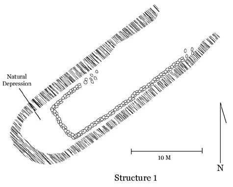
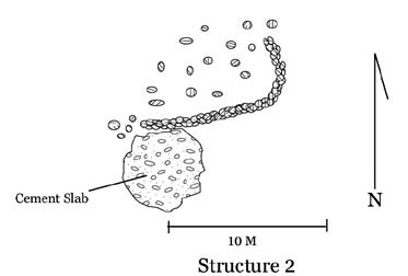
Structure 1 is a low, “J” shaped wall about 80 cm. high and 50 cm. wide, in the linear depression along the north shore. A 6-meter long wall segment crosses the depression near its southwest end. A short segment to the north and a long (ca. 20 M) segment to the south extend along the sides of the gully to the northeast. Structure 2 appears to be fragmentary. It lies in a field of coral rubble that may represent collapsed walls, and consists of a “J”-shaped wall segment about 8 meters on its long axis, three on its short. About 100 cm. high and 35 cm. thick, it is associated with a large slab of cemented coral.
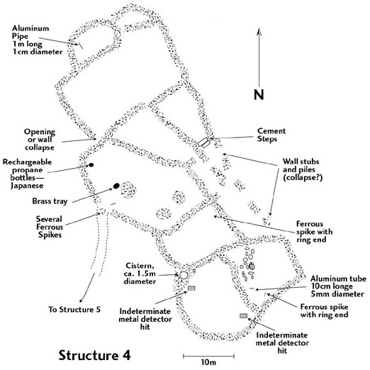
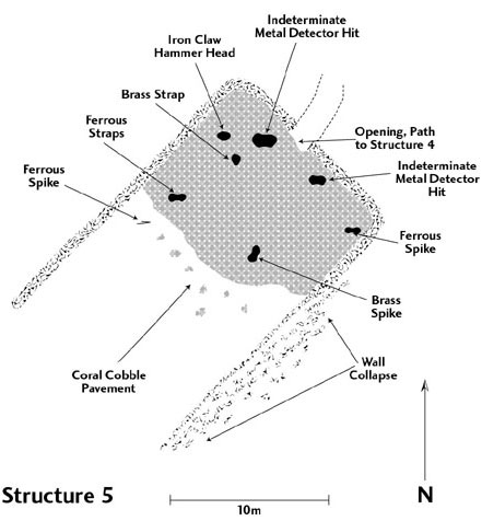
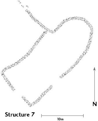
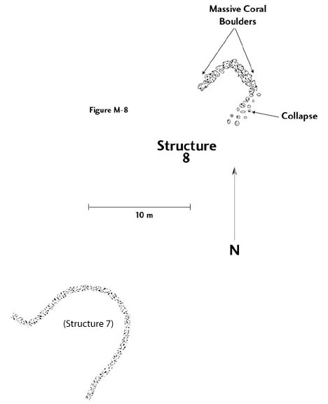
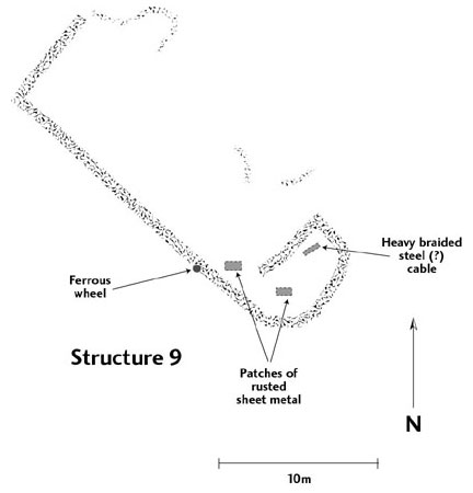
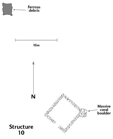
Structure 3 is a rather impressive circular wall about 120 cm. high, 35 to 50 cm. wide, and about 22 M in diameter. The wall is for the most part made up of stacked coral slabs, occasionally interspersed with large coral boulders or standing slabs. Three piles of coral are semi-symmetrically organized inside the circle, near its center. Metal detecting revealed an undefined lump of ferrous metal just outside the southeast arc of the circle, and a “hit” that could not be located on the inside of the circle nearby. Structure 3 appears likely to represent some kind of processing facility. Structure 4 is a complex curvilinear structure made up of twelve rooms or cells, some without evident entrances, others interconnected, with a pathway leading from an outside opening from northeast of the largest rooms, toward Structure 5. Wall construction is similar to that of Structure 3. The walls are 1 to 1.5 meters high, 35-50 cm. thick. Several building episodes appear to be represented; some walls contact but are not integrated with crossing walls. Low cement steps ascend one wall from a sort of narrow courtyard whose outside edge is defined by several low coral rubble piles. The whole structure is some 50 M long and up to 20 wide. Metal detector sweeps yielded a number of “hits,” most of which could not be found, but large amounts of thin ferrous metal were noted in small concentrations on the surface, together with a large brass(?) food serving tray and some ferrous spikes with ring ends. Apparent post-guano period material consisted of two small aluminum tubes and a propane tank with Japanese characters on it. Structure 4 looks like it might have been a residential facility for the Hawaiian guano workers. Structure 5, connected to Structure 4 by a fairly straight pathway through the coral rubble, is a straightforward rectilinear structure with an open end facing southwest toward the landing and a smaller opening in the northeast wall. About 20 M long and 12.5 M. wide, Structure 5 has walls over 2.5 M. high. The northeast end of the ruin appears to have been floored with a pavement of coral cobbles. Ferrous spikes, straps, a claw hammer head, a chain link, and a brass spike and strap were found in metal detector sweeps, along with hits that could not be identified. Structure 5 appears to have been a warehouse or storage facility of some kind associated with the landing, readily accessible from Structure 4. Structure 6 is a simple circular stone cairn on the landing beach, 2.5 M in diameter. Nearby is a concrete base, apparently for a flagstaff. Structure 7 is an odd, semi-rectangular structure with a half-oval attached room, southeast of Structure 5. It is about 10 M wide and 20 M long, oriented northeast-SW, with walls similar to those of Structure 4. A short distance northwest of Structure 7, Structure 8 is a small rectangular structure about three meters on a side, including massive corral boulders in its walls. Structure 9 is another rectilinear structure, 21 M long and 7 M wide, oriented NW-SE, with the usual stone walls. However, its southeast end is curved, and there is a short cross-wall that segments the southeast end from the rest of the structure. The north wall, if it ever existed, is mostly gone, but for a single tier of stones forming an indeterminate pattern on the rubble ground. A ferrous wheel lay on one of the walls, and a heavy braided steel cable was found inside the southeast end room. Structure 10 is a simple square ruin, 6 M on a side that incorporates a massive coral boulder in its northeast corner. Its walls are the usual construction, about 1 M high, and there is an 80 cm. wide doorway through its southwest wall. What appeared to be (and presumably were) narrow-gauge railbeds were noted running down from the vicinity of the structures into the guano "lagoon," but these were not mapped. As TIGHAR speculated before going to the island,18 it would be possible for an airplane to have “landed” in the ooze-filled pit (which from a distance resembles a lovely green field, or a shallow lagoon) and been obscured from view to the Colorado pilots both by the ooze itself and by the birds that would inevitably alight on it. If this were the case, of course, it could account for the metal detector readings indicating metal in the pit. The alternative explanation for the readings – discarded mining equipment – accounts for the readings at least as well, however. Maude reports that when he and Bevington inspected the island on October 26, 1937, less than four months after the Lockheed’s disappearance, the “lagoon” was “almost pure salt water.”19 Neither he nor Bevington report seeing any evidence of the Electra, Earhart, or Noonan.20, 21 Considering these near-contemporary observations, the fact that we found nothing in the reports of the Smithsonian expeditions to suggest the presence of aircraft wreckage, and the negative results of our survey but for the ambiguous metal detector readings in the guano pit, it appears very unlikely that McKean Island was where the World Flight ended. Though McKean does not appear to merit further work for purposes of the Earhart search, its ruins (and perhaps whatever lies in the guano pit besides the obvious) could yield useful data on the technology and sociology of 19th century guano mining, should questions about such mining arise that are amenable to archeological study. Study of the ruins might also provide some insight into the character of expatriate Hawaiian miner communities during the period. Certainly the ruins are worthy of preservation, particularly since such preservation requires no action other than discouraging the extremely rare visitors to the island from disturbing them. |
|||||||||||||||||||||
| NOTES | |
| 1 | Hague 1862:20. Back. |
| 2 | Maude 1940:6. Back. |
| 3 | Bryan 1942:68. Back. |
| 4 | Bryan 1942:67. Back. |
| 5 | Maude 1940:11. Back. |
| 6 | Bryan 1942:68. Back. |
| 7 | Ibid. Back. |
| 8 | No note, sorry. Back. |
| 9 | Bryan 1942:68. Back. |
| 10 | Hague 1862:20. Back. |
| 11 | Hague 1862:8. Back. |
| 12 | Hague 1862:20. Back. |
| 13 | Hague 1862:68. Back. |
| 14 | Maude 1940:5-6. Back. |
| 15 | Maude 1940:5. Back. |
| 16 | Maude 1940:6. Back. |
| 17 | TIGHAR 1989:60. Back. |
| 18 | Ibid. Back. |
| 19 | Maude 1937:13. Back. |
| 20 | Maude 1937:13; 1940:5-6; Maude personal communications 1990-99. Back. |
| 21 | Bevington personal communication 1992. Back. |
|
||||||||||
|