 |
by
Gary Quigg & Thomas F. King, Ph.D.
The International Group for Historic Aircraft Recovery
November 2007
In July, 2007, beach erosion uncovered a World War II vintage P-38 Lightning at Harlech Beach in Wales. In cooperation with local and national conservation, aviation, archaeological, and museum authorities, TIGHAR carried out survey operations on the airplane over a span of four days from October 8 to 11, 2007. The TIGHAR team comprised eight members from Wales and the United States.5
The P-38 was different from the wrecks discussed above in that it was virtually intact and half-buried in the intertidal zone, exposed only during a 2-hour period at low tide; at these times the aircraft was awash in 1 to 1.5 meters (approximately three to five feet) of water.
We devoted our first two-hour visit to a general inspection of the site. During the second we established metal posts to support a twenty meter baseline. As usual, the ends of the baseline were located using GPS, and with reference to local landmarks. Simultaneously we carried out a comprehensive metal detector sweep of the vicinity, marking “hits” with plastic posts which were measured in from the baseline. No excavations were undertaken.
The third day on site, October 10, provided excellent conditions for fieldwork with calm seas and full sunshine. We located fifteen important points on the airframe with reference to the baseline, and took additional GPS readings. Four team members concentrated on detailed digital photography, videography, and text recording, the latter with special attention to evidence of damage, deterioration, and marine encrustation. Two members carried out kite aerial photography (KAP), producing low-level vertical photo coverage that greatly enhanced our documentation. Work was completed during the fourth two-hour recording window under adverse wind and surf conditions which, however, permitted higher-elevation KAP imagery to document the overall site context. An overall site plan was produced as a result of the fieldwork, and Figure 4 is representative KAP imagery.
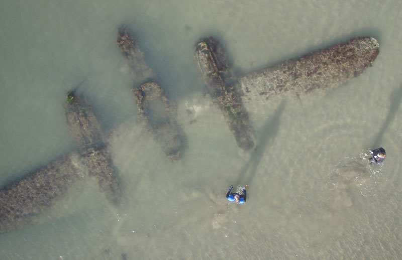
Figure 4: KAP imagery of P-38 site.
The recording method TIGHAR has applied to the Kellogg, Misty Fjords, Colonia and Harlech wrecks is simple, intuitive, and effective. It makes it possible to produce an accurate site plan, which can be used in organizing such other documentation as digital imagery, written notes, and video or audio recordings. In a nutshell, the method involves carrying out the following steps:
- Locate the wreck site.
- Establish a control or datum point close to but outside the boundaries of the wreckage distribution.
- Run a tape from the control point on any compass heading that transects the wreckage, or the part of the wreckage closest to the control point.
- Record the locations of key wreckage elements, other features, and significant observations, photographs, sample recoveries, or tests, with reference to the tape.
- If necessary, reorient and/or relocate the tape and repeat the process with each part of the wreckage distribution.
In the Kellogg case the documentation process took about eight hours, exclusive of travel time and time spent finding the site. At Misty Fjords the same process took roughly twelve hours, while each wreck site on Yap required about ten hours and the Harlech site required eight hours. In each case two to four people were needed to conduct the actual mapping, while three to five others were engaged in overall site inspection, surveys of surrounding areas, sample recovery in the Misty Fjords case, metal detecting and KAP in the Harlech case, and other support activities.
| 5 | For details see TIGHAR 2007. |
| Introduction & The Kellogg Site | Refining the Method: Misty Fjords & Colonia Airport | Maid of Harlech & Conclusion | Bibliography |
 |
Copyright 2021 by TIGHAR, a non-profit foundation. No portion of the TIGHAR Website may be reproduced by xerographic, photographic, digital or any other means for any purpose. No portion of the TIGHAR Website may be stored in a retrieval system, copied, transmitted or transferred in any form or by any means, whether electronic, mechanical, digital, photographic, magnetic or otherwise, for any purpose without the express, written permission of TIGHAR. All rights reserved. Contact us at: info@tighar.org • Phone: 610.467.1937 • JOIN NOW |