 |
by
Gary Quigg & Thomas F. King, Ph.D.
The International Group for Historic Aircraft Recovery
November 2007
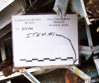
In August of 2004, a seven-member joint TIGHAR-USDA Forest Service team applied the methods developed for the Kellogg crash site to the documentation of 49-KET-00910, the site of a Lockheed Electra 10B crash in a remote part of the Misty Fjords Ranger District on the Tongass National Forest in Alaska. This plane, piloted by legendary bush pilot Harold Gillam, crashed in 1943; one passenger died from her injuries shortly after the crash, and Gillam froze to death trying to hike out, but the remaining four passengers were rescued by the U.S. Coast Guard after more than a month in the wild.3 The team flew in float planes to the general vicinity of the site, then backpacked for a day and a half through muskeg swamps and over precipitous, heavily wooded ridges terrain to a pre-selected campsite from which the wreck – which had been located from the air – could be accessed. This wreck was much more intact and concentrated than the Kellogg wreck, but was in heavier vegetation, again in a gully. Again, we used a sixty-meter tape on a compass heading from a GPS-located datum point as the baseline, and took measurements from points along the tape to locate specific aircraft elements and concentrations of wreckage. This produced the map shown in Figure Two. The site was heavily documented in digital imagery, and with Forest Service approval selected samples were recorded and removed for analysis. A documentary innovation in this case was a laminated recording board that could be cheaply produced and reused indefinitely to include locational and descriptive information in photographs (right).
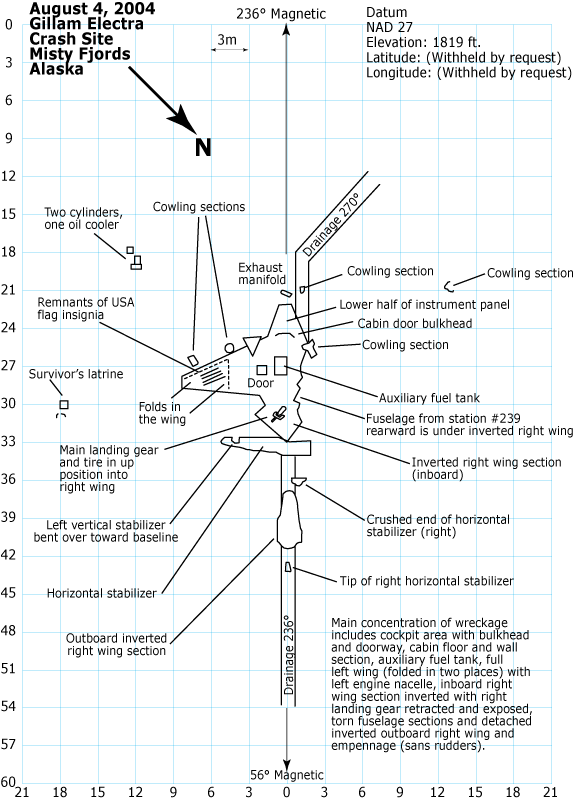
Figure 2: Site Map of Gillam Crash Site.
In 2006, TIGHAR received a contract from the Yap State Historic Preservation Officer in the Federated States of Micronesia to reconnoiter and offer management recommendations on several World War II Japanese aircraft in the vicinity of the old Colonia Airport near Yap’s capital, Colonia. Again time was of the essence, since the contract was of short duration and the wrecks were relatively complicated. The reconnaissance was also complicated by fairly dense tropical vegetation, but was simplified by the fact that this time the airplanes were on relatively level ground (though punctuated by bomb craters).4
In this case, we could lay out datum points and base lines with convenient reference to the aircraft or wreckage concentrations themselves, rather than being controlled by topography, and we added video to our suite of documentation methods, but otherwise we employed the same technique as at Misty Fjords and Kellogg. Figure Three is one of the site maps produced as a result.
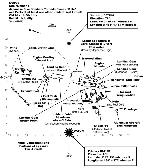
Figure 3. Site Map, Site #1, Old Airstrip Vicinity, Colonia Airport, Yap (FSM)
| 3 | For details see TIGHAR 2005. |
| 4 | For details see TIGHAR 2006. |
| Introduction & The Kellogg Site | Refining the Method: Misty Fjords and Colonia Airport | Maid of Harlech & Conclusion | Bibliography |
 |
Copyright 2021 by TIGHAR, a non-profit foundation. No portion of the TIGHAR Website may be reproduced by xerographic, photographic, digital or any other means for any purpose. No portion of the TIGHAR Website may be stored in a retrieval system, copied, transmitted or transferred in any form or by any means, whether electronic, mechanical, digital, photographic, magnetic or otherwise, for any purpose without the express, written permission of TIGHAR. All rights reserved. Contact us at: info@tighar.org • Phone: 610.467.1937 • JOIN NOW |