The TIGHAR team departed
Los Angeles on 27 January arriving in Fiji the next day. Mr. Teuatabo joined
the team at Nadi, Fiji on 29 January and, after a short commuter flight to
the Fijian island of Taveuni, the expedition took ship aboard M/V Matagi
Princess II for the four day voyage to Nikumaroro.
|
The
First Day |
Early on the morning
of 2 February the island came up on the ship’s radar and by 0700 the
first team members were ashore at the landing and clearing a trail across
to the lagoon shore. By fortunate coincidence, the tide was high which
permitted a launch to be walked through the main passage into the lagoon
without delay. The lagoon boat was in place and the trail from the landing
completed at 0835. The team then embarked for the trip down the lagoon,
arriving at the search area at 0900.
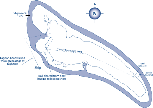
Although appearing
relatively open in early aerial photography, the area was found to be
now solidly overgrown with the tangled underbrush known in Gilbertese
as te mao (Scaevola frutescens). This made it particularly difficult
to navigate to the precise location where debris appears in the photos.
Without calibrated GPS (Global Positioning System) information, the
only sure method was to cut and physically measure transects across
the island from lagoon to ocean. Only by finding the area where the
width of the land matched the scaled distance in the photo could we
be certain that we were in the right place. This was a frustrating
and labor-intensive procedure which involved many hours of machete
work in temperatures averaging 106° F. By the end of the day two
transects had been cut and measured thus making it possible to define
the areas to be searched. The team departed the site at 1635 and was
back aboard ship by 1800.
|
|
The Second Day |
The team was on
site at 0755 and began building and searching boxes of terrain. From
a known point on a transect a line was cut 90° into the bush 10 meters
in length. From this point, another 10 meter line was cut paralleling
the original transect, then back again to form a box. Surveyor’s flagging
was used to create a physical boundary, thus permitting a thorough visual
inspection of the boxed area despite the nearly impenetrable vegetation.
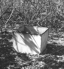 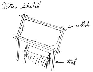 At 1012 cultural
(man-made) debris was encountered in an area 38.2 meters northeast of
the northern transect. Detailed examination of the site disclosed the
presence of a variety of objects comprising a small shelter or campsite
constructed of materials which clearly originated in the Gilbertese
settlement at the western end of the atoll. An unused roll of tar paper
roofing material suggests the possibility that the structure was never
actually completed. Of particular note was a relatively large (roughly
1 meter square) steel tank identical to others seen in the abandoned
village and which appears to have served as a cistern. An M-1 carbine
shell casing found nearby testifies to the site having been visited
by U.S. Coastguardsmen in 1944 or ’45. It seems logical that this is
the ”water collection device” reported and sketched by USCG
veteran Richard Evans. At 1012 cultural
(man-made) debris was encountered in an area 38.2 meters northeast of
the northern transect. Detailed examination of the site disclosed the
presence of a variety of objects comprising a small shelter or campsite
constructed of materials which clearly originated in the Gilbertese
settlement at the western end of the atoll. An unused roll of tar paper
roofing material suggests the possibility that the structure was never
actually completed. Of particular note was a relatively large (roughly
1 meter square) steel tank identical to others seen in the abandoned
village and which appears to have served as a cistern. An M-1 carbine
shell casing found nearby testifies to the site having been visited
by U.S. Coastguardsmen in 1944 or ’45. It seems logical that this is
the ”water collection device” reported and sketched by USCG
veteran Richard Evans.
The remains of
a steel barrel or drum was found in a location which matches reflections
from a large metallic object, designated “Candidate #1” in
the 1941 photo.
While part of the
team examined the shelter site, others continued to progressively search
designated sections of bush. By the end of the day no new cultural sites
had been found but strips of vegetation-free coral had been encountered
and mapped. These appeared to match in location and orientation, although
not in overall dimensions, the ”cleared” strips visible in
the early aerial photography. All team members were back aboard ship
by 1750. |
|
The
Third Day |
Once more on-site
by 0755, part of the team began the process of photographing, documenting
and mapping the shelter site while the rest of the team took up the
search for “Candidate #2.” Having resolved our on-the-ground
location with relation to the early aerial photographs, it was a relatively
simple matter to navigate to, box off, and examine the suspect area.
An exhaustive search turned up no cultural debris. In the spot most
closely matching that of Candidate #2, the team encountered a very old
buka tree (Pisonia grandis) – the only one in that particular
area and, in all probability, the anomaly seen in the photo.
At 1530 the work
on this part of the island was judged to be completed and a decision
was made to use the remainder of the day to correct an oversight from
the Niku II expedition. The map location of the gravesite excavated
in 1991, near which the remains of shoes believed to be those belonging
to Earhart and Noonan were found, had never been accurately established.
The team therefore relocated that site and measured its azimuth and
distance from landmarks identifiable on the map. The site exhibited
considerably more ground vegetation (specifically, networks of light
vines) than had been present in 1991, and looked very much as it had
when first noticed in 1989 during Niku I. A severely oxidized ferrous
fitting with what appears to be a brass cap was collected near the site
in the hope that it will provide some clue about the various types of
activity the area has seen over the years. The team departed the area
at 1635 and everyone was back aboard the ship an hour later. |
|
The
Fourth Day |
With the need to
begin the return voyage to Fiji that evening, this was to be the last
day of work on the island. The team was ashore by 0700 and the decision
was made to spend the available time in re-examining locations and features
in the village where airplane debris had been found in the past. By
0807 the “carpenter’s shop” had been re-located along
the shore of Taziman Passage. It was near this spot that Artifact 2-18,
the ”dado,” had been found in 1989. Although one wall and
some shelving had been standing then, the site was now leveled by subsequent
storm activity and identifiable only by the presence of massive objects
(the iron wheel and frame of a cart, a coil of heavy cable). Smaller
artifacts were either swept inland or buried under up to 5cm of sand.
While some of the team began a partial excavation of the carpenter’s
shop, others attempted to re-locate another site along the shoreline
where a sheet of aircraft-grade aluminum, cataloged as Artifact 2-2,
had been found in 1989. Bordered by poles set in the ground which were
notched at the top to support cross beams, the site had been littered
with glass bottles and other debris prompting the Niku I team to dub
this site “Noonan’s Tavern.” Efforts to re-locate
this site were, however, unsuccessful and it is feared that it has
been virtually obliterated by storms.
At approximately
1030 the excavation of the carpenter’s shop site produced two lengths
of shielded electrical cable. On the end of each cable was a single-pin
connector surrounded by a knurled tightening ring. The cables were very
unlike the other objects which had been found during the excavation
(mostly heavy ferrous tools and machine parts) and, while badly deteriorated,
appeared to have most of their component parts intact. On-site evaluation
was that these were consistent with cables and connectors for an American
radio of less than 100 watts output. Because the island radio station
had British equipment, and the U.S. Coast Guard station at the other
end of the atoll would likely have had a communications radio of more
than 100 watts, the cables were judged to be of sufficient interest
to merit their collection for further analysis. They were recovered
as Artifact 2-3-V-1 (TIGHAR project #2 , expedition #3, Village site,
object #1). Nothing further was collected from this site.
In the afternoon
an effort was made to re-locate a former dwelling site where several
aircraft parts were recovered in 1991. By 1340 a spot had been located
which was suspected of being that same location. (Later mapping and
comparison to 1991 Field Notes, however, established that identification
to be incorrect.) The site is sufficiently far inland from the shore
to show little or no sign of storm damage. A close examination of the
ground surface revealed the presence of several small objects and scraps
of material apparently left over from projects of handiwork. Among these
were items which appeared consistent with aircraft materials. These
included:
- A roughly 6cm
x 12cm (2.5 in. x 4.5 in.) sheet of uncolored transparent plastic
3mm (1/8 or .125 in.) in thickness from which rectangular pieces had
been cut. A smaller shard of the same material found nearby fits a
break in the bigger piece. Both pieces exhibit a slight but uniform
arc over their surface and were apparently once part of a larger sheet.
These were collected as Artifact 2-3-V-2. (See “Part #40552.”)
- A 15cm (6 in.)
length of what appears to be thin-gauge high-grade stainless steel
wire twisted together in a manner consistent with aircraft safety
wire. This was collected as Artifact 2-3-V-3.
- A rectangular
object 4.5cm x 4cm (1.75 in. x 1.5 in.) made of non-ferrous metal
(lead?) and giving the appearance of being a cast cover plate with
indentations in the back. The front features a circular logo with
the word “STURDEE.” This was collected as Artifact 2-3-V-4.
- A roughly 50cm
x 30cm (1.5 ft. x 1 ft.) sheet of apparent stainless steel estimated
to be as much as .060 in. in thickness from which rectangular pieces
had been cut. Designated Artifact 2-3-V-5, this object was not collected
but was left in situ.
- An electrical
“cannon plug.” This was collected as Artifact 2-3-V-6
- A very small
ferrous object, possibly a fuse holder, collected as Artifact 2-3-V-7.
Work on the island
was concluded at 1600 and all were back aboard ship by 1620 at which time
Mr. Teuatabo approved the export of the artifacts for research purposes.
The return voyage to Suva, Fiji was accomplished in five days and, on
February 10, 1996 the TIGHAR team returned by air to Los Angeles. Mr.
Teuatabo returned by air to Tarawa on February 11, 1996.
|
|