The International Group for Historic Aircraft Recovery
2366 Hickory Hill Road · Oxford, PA · 19363 · USA
610.467.1937 · info@tighar.org
|
The International Group for Historic Aircraft Recovery |
|||||
Page 4 |
||||||||||
The sketch the fisherman made of the wreck hanging in the net looks like a C-64, but it was made some thirty years after the event and in the context of his realization that what he saw may have been the Miller aircraft. It is possible, and even likely, that the press accounts that prompted Mr. Fisher to make the connection between his experience and the Miller disappearance included photos of a C-64. If so, those images may have unconsciously colored his recollection. However, without solid contradicting evidence there is no way to be sure his sketch is not an accurate representation of what he saw. We have found no record of any other high-wing, single-engine, fixed landing gear aircraft with American military markings lost in the Channel during or after WWII.
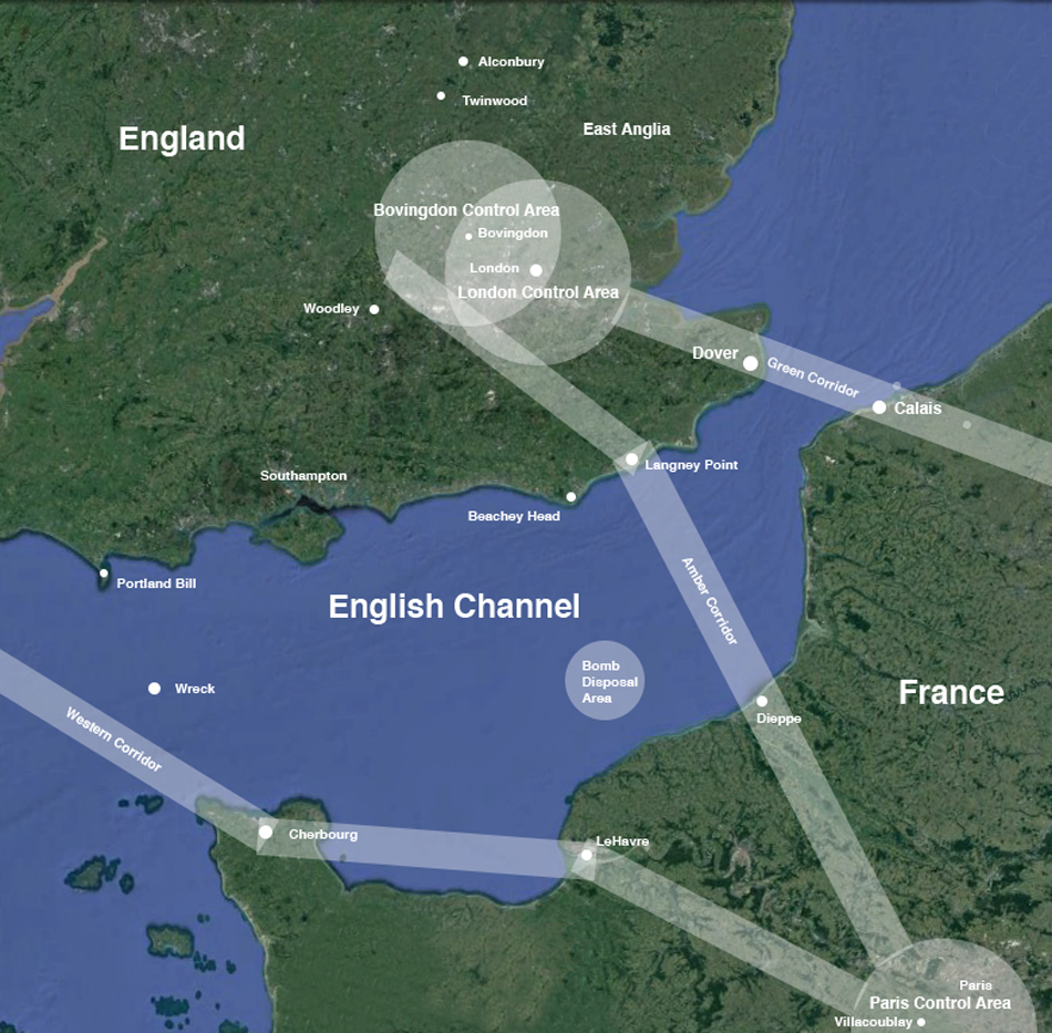
A key question in whether TIGHAR should consider conducting a search for the fisherman’s wreck is whether the aircraft carrying Miller could reasonably have come to grief at or near the place where the wreck was seen. Answering that question means making an informed assessment of the possibility that Morgan chose a route to the Far Shore that put him in that location. In December 1944 all administrative/transport flights from England to France and vice versa were required to use one of three air corridors – “safe zones” in which aircraft transiting to and from the Far Shore were assumed to be friendly. Aircraft crossing the coast outside those corridors risked being fired on by anti-aircraft batteries (see map next page). Normally, a flight from Twinwood to Villacoublay would travel via the Amber Corridor, but it is difficult to reconcile that route with the fisherman’s reported wreck location far to the west. If there is firm evidence that Morgan attempted to cross the channel via the Amber Corridor, the fisherman’s wreck can be reasonably discounted as being the plane carrying Glenn Miller and a search for the wreckage is not warranted.
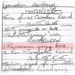
There are good reasons why Morgan may have followed the Amber Corridor. He was familiar with the route, having flown it many times before, and it was safe in that, even without official clearance, he would not be shot at. In 2014, the logbook of an amateur plane spotter at Woodley, 20 miles west of Bovingdon Control Area, was discovered to contain a notation that he saw or heard what he believed to be “1 Norseman going ESE” (or possibly SSE) and “2 Low Mosquitos” some time between 12:45pm and 3:00pm on December 15, 1944. If the presumed Norseman was 44-70285 the reported direction suggests Morgan was headed for the Amber Route. The Eighth Air Force statement of January 24, 1945 mentions a “C-64 type aircraft visual ID 14:33 ROC Beachey Head.” No original Royal Observer Corps record of such a sighting has been found. The ROC station at Beachey Head was 6 miles from Langney Point where the Amber Route crossed the coast. Morgan departed Twinwood at 1:55pm. The Beachey Head sighting was reportedly 38 minutes later at 2:33 p.m. The distance from Twinwood to the Beachey Head area via Bovingdon is 108 miles, suggesting an average speed of 170 mph. The published top speed of the C-64 is 162 mph, cruising speed 148 mph. Winds were light out of the south. If the reported time is accurate, the aircraft seen over Beachey Head cannot be 44-70285. If the identification of the aircraft type seen at or near Beachey Head was correct there was more than one C-64 in the air that afternoon. The aircraft at Woodley could be the Miller aircraft depending on the time it was seen or heard, but the logbook says only “afternoon” some time after 12:45pm and before 3:00pm. Morgan may have attempted to cross the Channel via the approved Amber Corridor, but there is no direct evidence that he did so.
|
||||||||||
| Back 1 2 3 4 5 Next | ||||||||||
|
|
||||||||||
|