 |
at the Old Colonia Airport,
Yap State
Federated States of Micronesia
By
The International Group for
Historic Aircraft Recovery (TIGHAR)
Final Report: September 30, 2006
Primary Author: Thomas F. King, Ph.D.
Field Team:
John Clauss, Field Director
Gary Quigg, Archaeologist
Craig Fuller, Aviation Archaeology Specialist
Walt Holm, Aviation Archaeology Specialist
Project Manager: Richard Gillespie
Acknowledgment of support: The work described in this report has been financed with Historic Preservation Funds from the National Park Service, United States Department of the Interior.
Disclaimer: The contents and opinions contained in this report do not necessarily reflect the views or policies of the U.S. Department of the Interior, nor does the mention of trade names or commercial products constitute endorsement or recommendation by the U.S. Department of the Interior.
Nondiscrimination and Equal Opportunity: This program received Federal funds from the U.S. National Park Service. Regulations of the U.S. Department of the Interior strictly prohibit unlawful discrimination in departmental Federally Assisted Programs on the basis of race, color, national origin, age, sex, sexual orientation, or handicap. Any person who believes he or she has been discriminated against in any program, activity, or facility operated by a recipient of Federal assistance should write to: Director, Equal Opportunity Program, U.S. Department of the Interior, National Park Service, P.O. Box 37127, Washington, D.C. 20013-7127.
Introduction and Acknowledgements
Under contract with the Historic Preservation Officer of the State of Yap, Federated States of Micronesia, The International Group for Historic Aircraft Recovery (TIGHAR) has conducted an archaeological assessment of World War II-era Japanese aircraft wrecks around the old Colonia Airport in Rull Municipality, Yap. This is the report of that assessment.
Our work was made possible by the Yap State Historic Preservation Officer, James Lukan, and his colleagues John Tun, Francis Reg, and Bernie Kadannged, as well as by Federated States of Micronesia Historic Preservation Officer Rufino Mauricio and the staff of the U.S. National Park Service Western Regional Office in San Francisco, particularly Paula Creech and David Look. The HPO not only made the project possible via its contract with TIGHAR, but facilitated our work through liaison with property owners and government officials, guiding our team around the island, and providing a variety of kinds of logistic support, notably including the very welcome loan of a 4-wheel drive vehicle. Yap Deputy Attorney General Ron Ledgerwood also facilitated our liaison with the State Government. We are also grateful to the owners of land at the old airport, Luis Burnoon and Luke Taman, who graciously permitted our work and showed us sites on their land. We also received important help from Patrick Rafranze, and very useful advice from Justin Taylan. We are grateful to all for the assistance given us; errors and omissions in this report are, of course, entirely our own.
Background
The airfield now known as the old Colonia airport (for its association with Colonia, the capital of Yap State), was the major Japanese military air installation in the islands of Yap during World War II, but to judge from Richard L. Dunn’s recent analysis of air battles over Yap, based on both Japanese and American military sources (Dunn 2006), its career was a brief one.
According to Dunn, the airfield was constructed in early 1944, and aircraft were deployed there by late May of that year. In mid-June, fighters and bombers from Yap sortied against American forces supporting the invasion of Saipan in the Northern Mariana Islands. To neutralize the Japanese base, the United States Army Air Force launched B-24 bombing attacks, beginning with a highly successful surprise raid on June 22nd. Forty-four fighters, four twin-engine bombers and a dive bomber were photographed on the airfield, and twenty of the total were reported destroyed or severely damaged.
U.S. B-24 raids continued on an almost daily basis through mid-July, and more sporadically into August, dropping tons of explosives on the runway, the adjacent dispersal area, and the aircraft parked there. Despite the massive damage inflicted by these raids, the Japanese were able routinely to launch fighters to oppose the U.S. bombers, attacking them with cannon and aerial bombs.1 By early August, however, the surviving Japanese aircraft had withdrawn to the Philippines to regroup, and Yap suffered only occasional U.S. raids for the remainder of the war.
When the U.S. Navy occupied Yap, it repaired the airfield for its own use. During Yap’s administration as part of the Trust Territory of the Pacific Islands (TTPI) the airfield was improved for civilian use as Yap International Airport. The remains of Japanese aircraft in the surrounding area became popular informal tourist attractions, and were heavily picked over by souvenir hunters and collectors of historic aircraft. Several airplanes have been removed by Japanese interests for restoration and exhibit.2 Use of the airport for aviation purposes was discontinued in the early 1980s when the new Yap International Airport was completed about a mile away, but the more accessible aircraft continued to be popular attractions, and remain such today.
In 2005, the Yap State Historic Preservation Officer and the U.S. National Park Service agreed on the need for a professional assessment of the aircraft wrecks around the old Colonia airport. The Historic Preservation Office contracted with The International Group for Historic Aircraft Recovery (TIGHAR) to undertake this assessment. This report describes TIGHAR’s work and its results, and offers recommendations for further study and conservation of the old Colonia airport World War II wrecks.
The Airfield and Dispersal Area
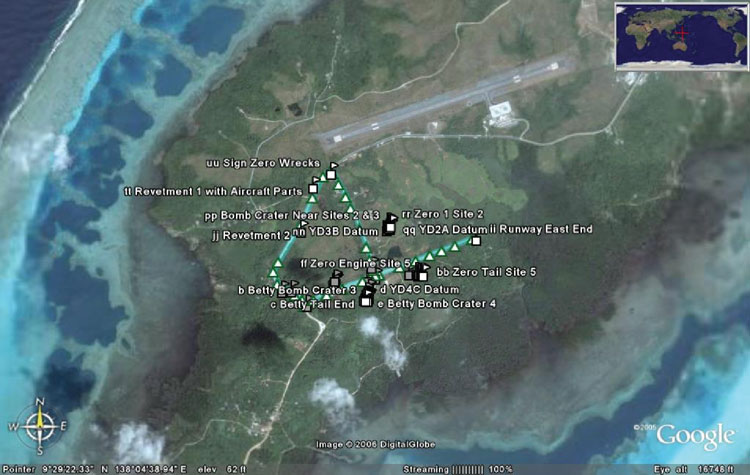
The TTPI-era airport runway occupies almost the same footprint as the old Japanese airstrip, though its alignment is slightly different and it is somewhat wider and longer (ca. 1,500 meters long). Northwest of the runway is the old Japanese dispersal area, where aircraft were kept dispersed to minimize potential damage from enemy attack. The dispersal area was crossed by several taxiways, two of which survive today as roads. With the airstrip itself, these form a roughly triangular area about 900 meters on its east side and slightly over a thousand meters on the west (Plate 1, Figure 1). During the war the taxiways were lined with earthen revetments to protect aircraft parked inside. A number of these revetments remain, damaged by bombing and overgrown in rainforest vegetation; our team visited three, and were told of several more. Aircraft were parked on both sides of the taxiways, and in the area northeast of the triangular area defined by the surviving taxiways, both within revetments and outside.
Fieldwork
 |
| Plate 1. Location of old Colonia Airport. |
Each wreck site was plotted using global positioning system (GPS) technology, extensively photographed and videotaped, and described in measured sketch-maps and field notes. Three other sites were located using GPS and more cursorily documented. At least five to seven additional wreck sites were reported by landowners and other knowledgeable parties, but could not be found in the time available. Aircraft identification was based on review of Tagaya 2001, Mikesh 1994, Nohara 1983, and other sources.
See http://www.missingaircrew.com/yap/yapmissions.asp for information on U.S. losses over Yap.
Documentation
Following are summary data on each site recorded. Site locations are shown in Figure 1, and summary data are presented in Table 1. Detailed condition reports on the seven sites examined are provided in the Appendix.
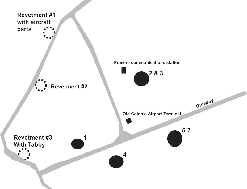
Figure 1: Schematic of study area showing key landmarks and sites.
| Site | Latitude | Longitude | Size | Description |
| #1 | 9° 29.193′ N | 138° 04.472′ E | Ca. 600 M2 | Wreckage of Nakajima “Kate” BN-5 torpedo bomber and some other aircraft parts in and around bomb crater |
| #2 | 9° 29.437′ N | 138° 04.413′ E | Ca. 253 M2 | Wreckage of Mitsubishi A6M3 “Zero” fighter |
| #3 | 9° 29.426′ N | 138° 04.716′ E | Ca. 100 M2 | Wreckage of Mitsubishi A6M5B “Zero” fighter |
| #4 | 9° 29.132′ N | 138° 04.621′ E | Ca. 850 M2 | Wreckage of Mitsubishi G4M1 “Betty” bomber with some intermixed “Zero” parts, around large bomb crater. |
| #5 | 9° 29.139′ N | 138° 04.508′ E | Wreckage of Mitsubishi A6M5 “Zero” fighter | |
| #6 | 9° 29.137′ N | 138° 04.500′ E | Wreckage of Mitsubishi A6M5 “Zero” fighter; wings only | |
| #7 | 9° 29.142′ N | 138° 04.496′ E | Wreckage of Mitsubishi A6M5 “Zero” fighter |
Table 1. Summary data on inspected aircraft.
Introduction |
 |
Copyright 2021 by TIGHAR, a non-profit foundation. No portion of the TIGHAR Website may be reproduced by xerographic, photographic, digital or any other means for any purpose. No portion of the TIGHAR Website may be stored in a retrieval system, copied, transmitted or transferred in any form or by any means, whether electronic, mechanical, digital, photographic, magnetic or otherwise, for any purpose without the express, written permission of TIGHAR. All rights reserved. Contact us at: info@tighar.org • Phone: 610.467.1937 • JOIN NOW |