 |
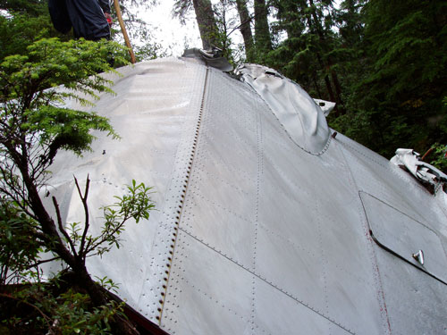 |
| Crumpled wreckage. TIGHAR photo by John Clauss. |
Extensive historical research was conducted by John T. Autrey and Martin V. Stanford, Archaeologists of the Ketchikan/Misty Fjords Ranger District, Tongass National Forest resulting in a detailed report to determine the eligibility of the Gillam crash site for inclusion on the National Register of Historic Places.9 TIGHAR member Arthur Rypinski also conducted extensive research. All found that the circumstances of the accident had been well documented in the Civil Aeronautics Board report and local media. Additional information was found in the U.S. Coast Guard archives and recent secondary sources.
The plane broke out of a ragged overcast at an elevation of about 2,500 feet, headed in a northerly direction and parallel to a ridge of mountains. There were other mountains ahead. Gillam turned off the right engine, headed toward a clearing on the side of the mountain, and pulled the plane up into a stalled attitude for a crash landing. The right wing contacted and sheared two tall trees at mid-height, and the plane swerved to the right about 90 degrees, struck the ground on the stub of the broken right wing and bottom of the fuselage, and stopped in an upright position.10
Another account based on information from the survivors indicated:
…the fuselage buckled and broke as they slowed almost to a halt before sliding into a deep gully burying them in snow just as another tree came down on top of them. They were now completely camouflaged and hidden from view.11
These descriptions and other survivor accounts indicated that there was no post-crash fire, and that the fuselage of the aircraft may have been sufficiently well preserved to retain intact dados if present. These accounts, and a map drawn by local aviation enthusiast Don “Bucky” Dawson, provided enough location details to allow Forest Service personnel to re-locate the crash site by air reconnaissance on July 27, 2004. Global Positioning Satellite (GPS) coordinates were obtained during the fly-over that would prove essential to locating the wreckage on foot in the densely wooded environment.
 |
Copyright 2021 by TIGHAR, a non-profit foundation. No portion of the TIGHAR Website may be reproduced by xerographic, photographic, digital or any other means for any purpose. No portion of the TIGHAR Website may be stored in a retrieval system, copied, transmitted or transferred in any form or by any means, whether electronic, mechanical, digital, photographic, magnetic or otherwise, for any purpose without the express, written permission of TIGHAR. All rights reserved. Contact us at: info@tighar.org • Phone: 610.467.1937 • JOIN NOW |